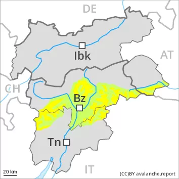
As a consequence of the stormy weather the wind slabs will increase in size once again on Thursday. The avalanche-prone wind slabs are to be avoided in particular in steep terrain. Avalanches can be released, even by a single winter sport participant and reach medium size. The number and size of avalanche prone locations will increase with altitude. Caution is to be exercised in the vicinity of peaks, as well as on steep shady slopes. As a consequence of warming there will be only a slight increase in the danger of wet and gliding avalanches. Meticulous route selection is recommended.
Snowpack
dp.6: cold, loose snow and wind
The sometimes storm force wind will transport the new snow and, in some cases, old snow as well, especially at elevated altitudes. The fresh wind slabs are in some cases prone to triggering. In some cases the wind slabs have bonded still only poorly with each other and the old snowpack, in particular on steep shady slopes and at high altitudes and in high Alpine regions. On sunny slopes and at intermediate altitudes the snowpack will soften slowly. The snowpack will be generally subject to considerable local variations. Above the tree line snow depths vary greatly, depending on the infuence of the wind. On sunny slopes below approximately 2200 m only a little snow is now lying.
Tendency
Further warming to the high Alpine regions. On Friday it will be exceptionally warm. The wind will be moderate over a wide area. The danger of dry avalanches will persist.
Danger level
treeline
Avalanche Problem
Wet snow
Treeline
Persistent weak layer
2200m
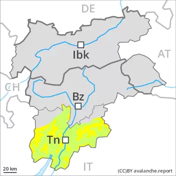
A mostly favourable avalanche situation will prevail. Wet and gliding avalanches as the day progresses.
Avalanches can in very isolated cases be released in the weakly bonded old snow, mostly by large additional loads, especially on very steep shady slopes above approximately 2200 m, as well as in gullies and bowls at elevated altitudes. In particular transitions from a shallow to a deep snowpack are unfavourable. As a consequence of warming there will be a gradual increase in the danger of wet and gliding avalanches, in particular on west, north and east facing slopes. Wet avalanches can in isolated cases be released in near-ground layers. Backcountry touring calls for meticulous route selection.
Snowpack
Faceted weak layers exist in the centre of the snowpack, in particular on shady slopes above approximately 2200 m. The snowpack will be generally subject to considerable local variations. Above the tree line snow depths vary greatly, depending on the infuence of the wind. The old snowpack consists of faceted crystals; its surface is loosely bonded and consists of surface hoar and faceted crystals. This applies in particular on shady slopes above the tree line. As a consequence of highly fluctuating temperatures a crust formed on the surface. From early morning the weather will be very warm. These weather conditions will bring about a weakening of the snowpack as the day progresses in all aspects. At intermediate altitudes the snowpack will soften in the morning already. On sunny slopes below approximately 2200 m only a little snow is now lying.
Tendency
Further warming to the high Alpine regions. On Friday it will be exceptionally warm. The wind will be moderate over a wide area. As a consequence of warming during the day and solar radiation wet and gliding avalanches are possible, but they will be mostly small.