Outside marked and open pistes a precarious avalanche situation will be encountered over a wide area.
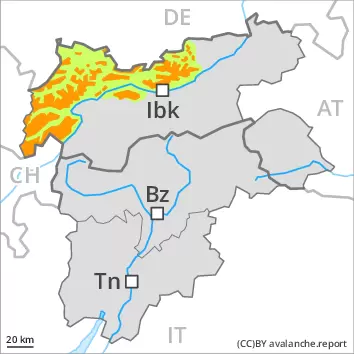
The new snow and wind slabs of the last two days represent the main danger. This applies in particular above approximately 2200 m. The avalanche prone locations are to be found in all aspects. They are sometimes covered with new snow and are therefore difficult to recognise. Single winter sport participants can release avalanches easily, including large ones. At elevated altitudes these avalanche prone locations are more prevalent and larger. Backcountry touring and other off-piste activities call for great caution and restraint.
Snowpack
dp.6: cold, loose snow and wind
A lot of snow fell in the last few days over a wide area. The sometimes storm force wind has transported the fresh and old snow significantly, especially at elevated altitudes. The warm fresh snow as well as the widespread wind slabs are prone to triggering. The wind slabs have bonded poorly with each other and the old snowpack, in particular on steep shady slopes and at high altitudes and in high Alpine regions. Below approximately 2200 m the snowpack is wet all the way through. On sunny slopes below approximately 2200 m only a little snow is now lying.
Tendency
Outgoing longwave radiation during the night will be good over a wide area. On Saturday it will be exceptionally warm. The wind will be moderate to strong over a wide area. The danger of dry avalanches will decrease gradually. As a consequence of mild temperatures the snow drift accumulations will stabilise during the next few days.
Danger level
2200m
Avalanche Problem
Wind-drifted snow
2200m
Fresh wind slabs represent the main danger.
The avalanche-prone wind slabs are to be avoided in all aspects above approximately 2200 m. Single winter sport participants can release avalanches easily. Mostly avalanches are medium-sized. The number and size of avalanche prone locations will increase with altitude. Caution is to be exercised in particular on steep shady slopes, as well as in the vicinity of peaks. As a consequence of warming during the day and solar radiation loose snow avalanches are possible, especially on steep sunny slopes, as well as in steep rocky terrain. Defensive route selection is recommended.
Snowpack
dp.6: cold, loose snow and wind
Less snow than expected fell in the last few days over a wide area. The sometimes storm force wind has transported the fresh and old snow significantly, especially at elevated altitudes. The warm fresh snow as well as the widespread wind slabs are in some cases still prone to triggering. In some cases the wind slabs have bonded still only poorly with each other and the old snowpack, in particular on steep shady slopes and at high altitudes and in high Alpine regions. The snowpack will be generally subject to considerable local variations. Above the tree line snow depths vary greatly, depending on the infuence of the wind. On sunny slopes below approximately 2200 m only a little snow is now lying.
Tendency
Outgoing longwave radiation during the night will be good over a wide area. On Saturday it will be exceptionally warm. The wind will be moderate over a wide area. As a consequence of mild temperatures the snow drift accumulations will stabilise during the next few days.
Danger level
2200m
Avalanche Problem
Wind-drifted snow
2200m
Fresh wind slabs are to be avoided.
The fresh wind slabs are to be avoided. Individual avalanche prone locations are to be found at elevated altitudes. Gliding avalanches are possible in isolated cases.
Snowpack
dp.6: cold, loose snow and wind
Below approximately 2200 m the snowpack is wet all the way through. The sometimes strong wind will transport only a little snow. Wind slabs will form in particular at elevated altitudes.
Tendency
Outgoing longwave radiation during the night will be good over a wide area. On Saturday it will be exceptionally warm. As a consequence of mild temperatures the snow drift accumulations will stabilise during the next few days.
Danger level
2200m
Avalanche Problem
Wind-drifted snow
2200m
Fresh wind slabs require caution.
The fresh wind slabs can in some places be released by a single winter sport participant. These are lying on the unfavourable surface of an old snowpack in particular on shady slopes above approximately 2200 m. They are to be avoided as far as possible. In isolated cases avalanches are medium-sized. The number and size of avalanche prone locations will increase with altitude. Caution is to be exercised in the vicinity of peaks, as well as adjacent to ridgelines. The avalanche prone locations are easy to recognise.
Snowpack
dp.6: cold, loose snow and wind
The sometimes storm force wind has transported the fresh and old snow, especially at elevated altitudes. The fresh wind slabs are in some cases prone to triggering. In some cases the wind slabs have bonded still only poorly with each other and the old snowpack, in particular on steep shady slopes and at high altitudes and in high Alpine regions. The snowpack will be generally subject to considerable local variations. Above the tree line snow depths vary greatly, depending on the infuence of the wind. On sunny slopes below approximately 2200 m only a little snow is now lying.
Tendency
Outgoing longwave radiation during the night will be good over a wide area. On Saturday it will be exceptionally warm. The wind will be moderate over a wide area. As a consequence of mild temperatures the snow drift accumulations will stabilise during the next few days.
Danger level
1800m
Avalanche Problem
Wet snow
1800m
Wind-drifted snow
2200m
A mostly favourable avalanche situation will prevail. Small avalanches and moist snow slides are still possible in particular in the second half of the day.
As a consequence of warming there will be a gradual increase in the danger of wet and gliding avalanches, in particular on west, north and east facing slopes. Wet avalanches can in isolated cases be released in near-ground layers. The fresh and somewhat older wind slabs are lying on the unfavourable surface of an old snowpack in particular on shady slopes above approximately 2200 m. They are to be avoided as far as possible. Avalanches can be triggered in the various wind slab layers and reach medium size. Caution is to be exercised in the vicinity of peaks, as well as at transitions from a shallow to a deep snowpack, when entering gullies and bowls for example. The number and size of avalanche prone locations will increase with altitude. Backcountry touring calls for meticulous route selection.
Snowpack
Faceted weak layers exist in the centre of the snowpack, in particular on shady slopes above approximately 2200 m. Above the tree line snow depths vary greatly, depending on the infuence of the wind. The fresh wind slabs are in some cases prone to triggering. The old snowpack consists of faceted crystals; its surface is loosely bonded and consists of surface hoar and faceted crystals. This applies in particular on shady slopes above the tree line. As a consequence of highly fluctuating temperatures a crust formed on the surface. From early morning the weather will be very warm. These weather conditions will bring about a weakening of the snowpack as the day progresses in all aspects. At intermediate altitudes the snowpack will soften in the morning already. On sunny slopes below approximately 2200 m only a little snow is now lying.
Tendency
On Saturday it will be very warm. As a consequence of warming during the day and solar radiation more wet and gliding avalanches are possible, but they will be mostly small.
Danger level
treeline
Avalanche Problem
Wet snow
Treeline
A mostly favourable avalanche situation will prevail. Small avalanches and moist snow slides are still possible in particular in the second half of the day.
As a consequence of warming there will be a gradual increase in the danger of wet and gliding avalanches, in particular on west, north and east facing slopes. Avalanches can in very isolated cases be released in near-ground layers, mostly by large additional loads, especially on very steep shady slopes above approximately 2200 m, as well as in gullies and bowls at elevated altitudes. In particular transitions from a shallow to a deep snowpack are unfavourable.
Snowpack
Faceted weak layers exist in the centre of the snowpack, in particular on shady slopes above approximately 2200 m. Above the tree line snow depths vary greatly, depending on the infuence of the wind. The old snowpack consists of faceted crystals; its surface is loosely bonded and consists of surface hoar and faceted crystals. This applies in particular on shady slopes at high altitude. As a consequence of highly fluctuating temperatures a crust formed on the surface. Today the weather will be very warm. These weather conditions will bring about a rapid weakening of the snowpack from the early morning in all aspects. On sunny slopes below approximately 2200 m only a little snow is now lying.
Tendency
On Saturday it will be very warm. As a consequence of warming during the day and solar radiation more wet and gliding avalanches are possible, but they will be mostly small.