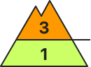
Fresh wind slabs are to be evaluated with care and prudence. This applies at high altitudes and in high Alpine regions. Slight increase in danger of moist snow slides as a consequence of warming during the day and solar radiation.
The new snow and wind slabs of the last few days represent the main danger. The fresh wind slabs can still be released by a single winter sport participant. The avalanche prone locations are to be found in particular on steep northwest to north to east facing slopes above approximately 2300 m. They are sometimes covered with new snow and are therefore difficult to recognise. Caution is to be exercised in particular in the vicinity of peaks, as well as adjacent to ridgelines. At elevated altitudes these avalanche prone locations are more prevalent and larger. In isolated cases avalanches are large. Slight increase in danger of moist snow slides as a consequence of warming during the day and solar radiation. This applies on extremely steep sunny slopes. Snow sport activities outside marked and open pistes call for experience in the assessment of avalanche danger.
Snowpack
dp.6: cold, loose snow and wind dp.10: springtime scenario
A lot of snow fell in the last few days over a wide area. The sometimes storm force wind has transported the fresh and old snow significantly. This applies at elevated altitudes. In some cases the wind slabs have bonded poorly with the old snowpack, in particular on steep shady slopes above approximately 2300 m. Above the tree line snow depths vary greatly, depending on the infuence of the wind. On sunny slopes below approximately 2200 m only a little snow is now lying. The weather will be exceptionally warm. As a consequence of sharply rising temperatures and solar radiation the snowpack will settle. The snowpack is moist and its surface has a melt-freeze crust that is not capable of bearing a load. This applies in particular on sunny slopes and at low and intermediate altitudes.
Tendency
Gradual decrease in avalanche danger. Outgoing longwave radiation during the night will be good over a wide area. On Sunday it will be exceptionally warm. The wind will be strong in some localities. As a consequence of mild temperatures the snow drift accumulations will stabilise.
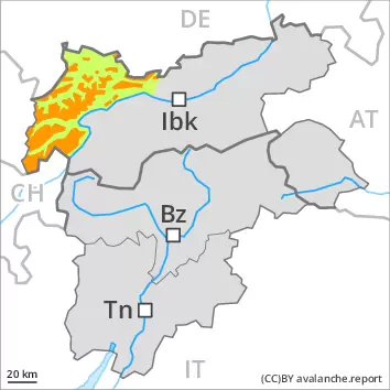
Danger level
2300m
Avalanche Problem
Wind-drifted snow
2300m
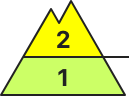
Fresh wind slabs require caution. Slight increase in danger of moist snow slides as a consequence of warming during the day and solar radiation.
Fresh wind slabs represent the main danger. The fresh wind slabs can in some places be released by a single winter sport participant. These are lying on the unfavourable surface of an old snowpack in particular on shady slopes above approximately 2300 m. They are to be avoided as far as possible. In isolated cases avalanches are medium-sized. The number and size of avalanche prone locations will increase with altitude. Caution is to be exercised in particular in the vicinity of peaks, as well as adjacent to ridgelines. The avalanche prone locations are easy to recognise. Slight increase in danger of moist snow slides as a consequence of warming during the day and solar radiation. This applies on extremely steep sunny slopes.
Snowpack
dp.6: cold, loose snow and wind dp.10: springtime scenario
The sometimes storm force wind has transported the fresh and old snow. This applies at elevated altitudes. In some cases the wind slabs have bonded still only poorly with the old snowpack, in particular on steep shady slopes above approximately 2300 m. The snowpack will be generally subject to considerable local variations. Above the tree line snow depths vary greatly, depending on the infuence of the wind. On sunny slopes below approximately 2200 m only a little snow is now lying. The weather will be exceptionally warm. As a consequence of sharply rising temperatures and solar radiation the snowpack will settle. The snowpack is moist and its surface has a melt-freeze crust that is not capable of bearing a load. This applies in particular on sunny slopes and at low and intermediate altitudes.
Tendency
Outgoing longwave radiation during the night will be good over a wide area. On Sunday it will be exceptionally warm. The wind will be strong in some localities. As a consequence of mild temperatures the snow drift accumulations will stabilise.
Danger level
Slight increase in danger of moist snow slides as a consequence of warming during the day and solar radiation.
A low (level 1) danger of moist snow slides during the day exists. This applies on extremely steep sunny slopes.
Snowpack
dp.10: springtime scenario
The snowpack is moist and its surface has a melt-freeze crust that is not capable of bearing a load. This applies in particular on sunny slopes, as well as at low and intermediate altitudes. On extremely steep sunny slopes the snowpack will soften during the day. On sunny slopes below approximately 2200 m only a little snow is now lying. The weather will be exceptionally warm. Above the tree line snow depths vary greatly, depending on the infuence of the wind. The wind slabs of the last few days have bonded well with the old snowpack.
Tendency
Outgoing longwave radiation during the night will be good over a wide area. On Sunday it will be exceptionally warm.