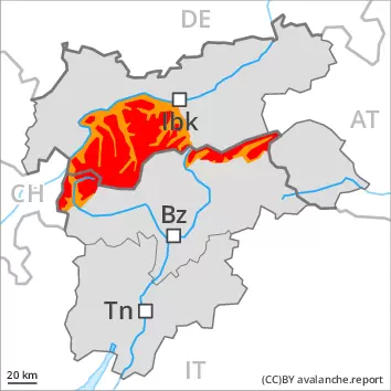
As a consequence of rising temperatures, heavy snowfall and the strong to storm force northwesterly wind, a dangerous avalanche situation will develop. Large natural avalanches are to be expected.
Avalanches can occur easily or triggered naturally. From the second half of the night more frequent natural avalanches are to be expected in all altitude zones. Avalanches can reach very large size in isolated cases in the regions exposed to heavier precipitation. This applies in particular on wind-protected north, northeast and east facing slopes, as well as adjacent to ridgelines in all aspects above the tree line. Outside marked and open pistes a dangerous avalanche situation will be encountered over a wide area. Large quantities of fresh snow and the wind-drifted snow must be evaluated with care and prudence in all aspects. The extensive wind slabs can be released easily by a single winter sport participant. This also applies on very steep slopes at low and intermediate altitudes.
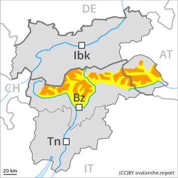
Snowpack
dp.6: cold, loose snow and wind
50 to 100 cm of snow, and even more in some localities, has fallen since Sunday. Wednesday: 50 to 100 cm of snow, and even more in some localities, will fall. The wind will be strong to storm force. The strong wind will transport the new snow significantly. The various wind slabs have bonded poorly together. They are lying on soft layers especially on wind-protected north, northeast and east facing slopes. Isolated avalanche prone weak layers exist in the centre of the old snowpack.
Tendency
The danger of natural avalanches will decrease gradually. Outside marked and open pistes a critical avalanche situation will be encountered over a wide area.
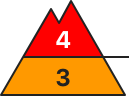
Danger level
treeline
Avalanche Problem
New snow
Treeline
New snow
Treeline
As a consequence of rising temperatures, heavy snowfall and the strong to storm force northwesterly wind, a dangerous avalanche situation will develop. Natural avalanches are to be expected as the day progresses.
Avalanches can occur easily or triggered naturally. As a consequence of warming more frequent medium-sized to large natural avalanches are to be expected in all altitude zones. Outside marked and open pistes a precarious avalanche situation will be encountered over a wide area. Large quantities of fresh snow and the wind-drifted snow must be evaluated with care and prudence in all aspects. The extensive wind slabs can be released easily by a single winter sport participant. This also applies on very steep shady slopes at intermediate altitudes.
Snowpack
dp.6: cold, loose snow and wind
Over a wide area 20 to 50 cm of snow, and even more in some localities, has fallen since Monday. 30 to 50 cm of snow, and even more in some localities, will fall on Wednesday. The wind will be strong to storm force. The wind will transport the new snow significantly. In some cases the various wind slabs have bonded poorly together. The warm fresh snow as well as the extensive wind slabs will be deposited on soft layers in all aspects above the tree line. The old snowpack is faceted and weak, especially on wind-protected shady slopes in the western part of the main Alpine ridge.
Tendency
The danger of natural avalanches will decrease gradually. Outside marked and open pistes a critical avalanche situation will be encountered over a wide area.
Danger level
treeline
Avalanche Problem
Wind-drifted snow
Treeline
Wind-drifted snow
Treeline
The avalanche conditions are precarious. Fresh wind slabs represent the main danger.
The fresh wind slabs are mostly thick and can be released easily. The avalanche prone locations are to be found especially on wind-protected slopes and generally above the tree line, also on steep shady slopes in areas close to the tree line. Mostly avalanches are medium-sized. As a consequence of new snow and stormy weather the prevalence and size of these avalanche prone locations will increase as the day progresses. Especially in shady places that are protected from the wind more frequent medium-sized natural avalanches are possible as the snowfall level rises. In regions neighbouring those that are subject to danger level 4 (high) the avalanche prone locations are more prevalent and the danger is greater.
Snowpack
dp.6: cold, loose snow and wind
10 to 30 cm of snow has fallen since Monday. Wednesday: Over a wide area 10 to 20 cm of snow, and even more in some localities, will fall. The wind will be strong to storm force. The strong wind will transport the new snow significantly. The various wind slabs have bonded insufficiently with each other and the old snowpack. They are lying on soft layers in particular on steep north, northeast and east facing slopes.
Tendency
Slight decrease in avalanche danger.
Danger level
treeline
Avalanche Problem
Wind-drifted snow
Treeline
Wind slabs are to be evaluated with care and prudence.
Wind slabs represent the main danger. The fresh wind slabs can be released by a single winter sport participant in some cases at high altitudes and in high Alpine regions. The avalanche prone locations are to be found especially on steep shady slopes and adjacent to ridgelines and in pass areas. Avalanches are rather small. As a consequence of new snow and wind the wind slabs will increase in size additionally. They are to be avoided in steep terrain. In steep terrain there is a danger of falling on the hard snow surface.
Snowpack
dp.6: cold, loose snow and wind
5 to 15 cm of snow will fall. The wind will be strong to storm force. The strong wind will transport the snow. The wind slabs are lying on soft layers in particular on steep shady slopes. The old snowpack will be in most cases stable. At elevated altitudes snow depths vary greatly, depending on the infuence of the wind. Only a small amount of snow is lying for the time of year.