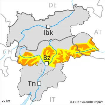
As a consequence of new snow and wind a precarious avalanche situation will prevail.
The fresh snow and the extensive wind slabs that are being formed by the storm force northwesterly wind represent the main danger. Avalanches can be released easily or triggered naturally. In some places avalanches can release the weakly bonded old snow as well and reach large size. Remotely triggered avalanches are possible. The avalanche prone locations are prevalent and are barely recognisable because of the poor visibility. They are to be found in all aspects above the tree line, also on steep shady slopes in areas close to the tree line, as well as on wind-loaded slopes at high altitudes and in high Alpine regions. In the regions with a lot of snow gliding avalanches and snow slides are to be expected. The current avalanche situation calls for extensive experience in the assessment of avalanche danger and great restraint.
Snowpack
dp.6: cold, loose snow and wind dp.7: snow-poor zones in snow-rich surrounding
Over a wide area 30 to 40 cm of snow, and even more in some localities, will fall until Monday. The wind will be strong to storm force. The fresh snow and the extensive wind slabs that are being formed by the northwesterly wind will be deposited on soft layers in particular on west to north to east facing aspects. In the course of the day the wind slabs will increase in size once again. In some cases the various wind slabs have bonded still only poorly with each other and the old snowpack. Towards its base, the snowpack is faceted and weak, especially on wind-protected shady slopes. Fresh avalanches and whumpfing sounds and the formation of shooting cracks when stepping on the snowpack are a clear indication of a weakly bonded snowpack.
Tendency
The snowpack remains prone to triggering. As a consequence of the sometimes storm force wind the wind slabs will increase in size additionally on Tuesday.
Danger level
Avalanche Problem
Wind-drifted snow
Gliding snow
As a consequence of new snow and wind a precarious avalanche situation will be encountered in some regions.
The fresh snow and the extensive wind slabs that are being formed by the storm force northwesterly wind represent the main danger. The fresh and older wind slabs can be released even by a single winter sport participant. The avalanche prone locations are prevalent and are barely recognisable because of the poor visibility. They are to be found in all aspects above the tree line, also on steep shady slopes in areas close to the tree line, as well as on wind-loaded slopes at high altitudes and in high Alpine regions. In some places avalanches can release the weakly bonded old snow as well and reach large size. Remotely triggered avalanches are possible. On steep grassy slopes gliding avalanches and snow slides are possible. The current avalanche situation calls for extensive experience in the assessment of avalanche danger and great restraint.
Snowpack
dp.6: cold, loose snow and wind dp.7: snow-poor zones in snow-rich surrounding
Over a wide area 20 to 30 cm of snow, and even more in some localities, will fall until Monday. The wind will be strong to storm force. The fresh snow and the extensive wind slabs that are being formed by the northwesterly wind will be deposited on soft layers in particular on west to north to east facing aspects. In the course of the day the wind slabs will increase in size once again. In some cases the various wind slabs have bonded still only poorly with each other and the old snowpack. Towards its base, the snowpack is faceted and weak, especially on wind-protected shady slopes. Fresh avalanches and whumpfing sounds and the formation of shooting cracks when stepping on the snowpack are a clear indication of a weakly bonded snowpack.
Tendency
The snowpack remains prone to triggering. As a consequence of the sometimes storm force wind the wind slabs will increase in size additionally on Tuesday.
Danger level
treeline
Avalanche Problem
Wind-drifted snow
Treeline
Persistent weak layer
Treeline
Wind-drifted snow
Treeline
As a consequence of new snow and wind a sometimes precarious avalanche situation will prevail.
The fresh snow and the wind slabs that are being formed by the storm force northwesterly wind represent the main danger. Avalanches can be released, even by a single winter sport participant and reach medium size. Avalanches can additionally be released in the weakly bonded old snow also, in particular on steep shady slopes. The avalanche prone locations are prevalent and are barely recognisable because of the poor visibility. They are to be found in all aspects above the tree line, especially on steep shady slopes in areas close to the tree line, as well as on wind-loaded slopes at high altitudes and in high Alpine regions. In the regions neighbouring those that are subject to danger level 4 (high) the avalanche danger is higher. In the regions with a lot of snow gliding avalanches and snow slides are possible. The current avalanche situation calls for extensive experience in the assessment of avalanche danger and great restraint.
Snowpack
dp.6: cold, loose snow and wind dp.7: snow-poor zones in snow-rich surrounding
Over a wide area 10 to 20 cm of snow, and even more in some localities, will fall until Monday. The wind will be strong to storm force. The fresh snow and the wind slabs that are being formed by the northwesterly wind will be deposited on soft layers. In the course of the day the wind slabs will increase in size once again. In some cases the various wind slabs have bonded still only poorly with each other and the old snowpack. Towards its base, the snowpack is faceted, especially on wind-protected shady slopes. Whumpfing sounds and the formation of shooting cracks when stepping on the snowpack are a clear indication of a weakly bonded snowpack.
Tendency
The snowpack remains prone to triggering. As a consequence of the sometimes storm force wind the wind slabs will increase in size additionally on Tuesday.
Danger level
treeline
Avalanche Problem
Wind-drifted snow
Treeline
Persistent weak layer
2200m
Wind slabs and weakly bonded old snow represent the main danger.
As a consequence of new snow and a strong northwesterly wind, avalanche prone wind slabs will form in all aspects. They are to be avoided especially in extremely steep terrain. Avalanches can in some places be released, even by a single winter sport participant and reach medium size. The avalanche prone locations are prevalent and are barely recognisable because of the poor visibility. In the regions neighbouring those that are subject to danger level 3 (considerable) the avalanche danger is higher. The current avalanche situation calls for experience in the assessment of avalanche danger and great restraint.
Snowpack
dp.6: cold, loose snow and wind dp.1: deep persistent weak layer
Over a wide area 5 to 10 cm of snow, and even more in some localities, will fall until Monday. The wind will be strong to storm force. The fresh snow and the mostly small wind slabs that are being formed by the northwesterly wind will be deposited on soft layers. In the course of the day the wind slabs will increase in size once again. In some cases the various wind slabs have bonded still only poorly with each other and the old snowpack. Towards its base, the snowpack is faceted, especially on wind-protected shady slopes. Whumpfing sounds and the formation of shooting cracks when stepping on the snowpack are a clear indication of a weakly bonded snowpack.
Tendency
As a consequence of the sometimes storm force wind the wind slabs will increase in size additionally on Tuesday.
Danger level
treeline
Avalanche Problem
Persistent weak layer
Treeline
Wind slabs and weakly bonded old snow require caution.
The older wind slabs can be released in isolated cases at high altitudes and in high Alpine regions. As a consequence of new snow and a strong to storm force northwesterly wind, mostly small wind slabs will form. The avalanche prone locations are to be found in particular on very steep shady slopes and adjacent to ridgelines and in gullies and bowls. The avalanche prone locations are sometimes covered with new snow and are barely recognisable because of the poor visibility. They are to be avoided especially in extremely steep terrain. In the regions neighbouring those that are subject to danger level 2 (moderate) the avalanche danger is higher. Mostly avalanches are small.
Snowpack
dp.6: cold, loose snow and wind
In some regions 2 to 10 cm of snow will fall above approximately 1000 m. Fresh and somewhat older wind slabs are in isolated cases prone to triggering on very steep shady slopes. The old snowpack will be generally stable. At elevated altitudes snow depths vary greatly, depending on the infuence of the wind. Only a small amount of snow is lying for the time of year.
Tendency
The avalanche danger will persist. As a consequence of the sometimes storm force wind the wind slabs will increase in size moderately.