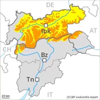
As a consequence of snowfall and the strong to storm force wind, a sometimes critical avalanche situation will develop.
The fresh snow as well as the wind slabs that are being formed by the strong to storm force northwesterly wind can be released by a single winter sport participant in all aspects above the tree line. As the precipitation becomes more intense individual natural avalanches are possible, even medium-sized ones.
Avalanches can in some places be released in deeper layers, even by a single winter sport participant. This applies on steep west, north and east facing slopes between approximately 2200 and 2600 m. Avalanches can in some cases reach dangerously large size.
As a consequence of the new snow there will be an additional increase in the danger of gliding avalanches, in the regions exposed to heavier precipitation especially on steep grassy slopes.
Snowpack
dp.6: cold, loose snow and wind dp.2: gliding snow
Northern Oetz and Stubai Alps, Karwendel Mountains, Tuxer Alps, Zillertal Alps, Wilder Kaiser Mountains- Waidring Alps as well as Venediger Range: 30 to 50 cm of snow, and even more in some localities, will fall. In the other regions 15 to 30 cm of snow will fall. The wind will be strong to storm force over a wide area.
As a consequence of new snow and northwesterly wind, wind slabs will form in all aspects. The fresh wind slabs are bonding poorly with the old snowpack in particular on wind-protected shady slopes. They are prone to triggering. In its middle, the snowpack is faceted and weak, especially on shady slopes between approximately 2200 and 2600 m.
Tendency
The fresh snow and the wind slabs must be evaluated with care and prudence.
Danger level
treeline
Avalanche Problem
Wind-drifted snow
Treeline
Persistent weak layer
2600m
2200m
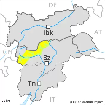
As a consequence of snowfall and the strong to storm force wind, fresh snow drift accumulations will form.
Some fresh snow and very particularly the wind slabs formed by the strong to storm force northwesterly wind represent the main danger. The fresh wind slabs are mostly rather small but prone to triggering. They can be released even by a single winter sport participant especially on steep shady slopes above the tree line. The avalanche prone locations are to be found in places that are protected from the wind and in gullies and bowls, and behind abrupt changes in the terrain.
Avalanches can in some places be released in deeper layers, even by a single winter sport participant. This applies on steep west, north and east facing slopes between approximately 2200 and 2600 m. Avalanches can in some cases reach dangerously large size.
Snowpack
dp.6: cold, loose snow and wind dp.7: snow-poor zones in snow-rich surrounding
Less new snow than expected: Over a wide area 5 to 10 cm of snow, and even more in some localities, has fallen since yesterday. The wind will be strong to storm force.
As a consequence of new snow and northwesterly wind, wind slabs will form in all aspects. The fresh wind slabs are bonding poorly with the old snowpack in particular on wind-protected shady slopes. In its middle, the snowpack is faceted and weak, especially on shady slopes between approximately 2200 and 2600 m.
Tendency
The fresh wind slabs represent the main danger.
Danger level
treeline
Avalanche Problem
Wind-drifted snow
Treeline
Fresh wind slabs are to be evaluated with care and prudence.
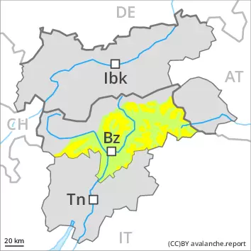
Some fresh snow and very particularly the wind slabs formed by the strong to storm force northwesterly wind represent the main danger. The fresh wind slabs are mostly rather small but prone to triggering. They can be released even by a single winter sport participant especially on steep shady slopes above the tree line. The avalanche prone locations are to be found in gullies and bowls, and behind abrupt changes in the terrain.
In very isolated cases dry avalanches can also be triggered in the old snowpack, especially on very steep shady slopes at transitions from a shallow to a deep snowpack, this applies in particular in case of a large load.
Snowpack
dp.6: cold, loose snow and wind
In some regions up to 5 cm of snow, and even more in some localities, has fallen since Monday. The wind will be strong to storm force. The fresh wind slabs are bonding poorly with the old snowpack in particular on wind-protected shady slopes. They are mostly rather small but prone to triggering. In its middle, the snowpack is faceted and weak. This applies on shady slopes above approximately 2200 m.
Tendency
The wind will be strong to storm force. Further wind slabs will form.