Further increase in danger of wet and gliding avalanches in the course of the day.
The surface of the snowpack will cool hardly at all during the overcast night and will already be soft in the early morning. As the day progresses more frequent medium-sized and, in isolated cases, large wet and gliding avalanches are possible. This applies especially on steep sunny slopes below approximately 2800 m, as well as in all aspects at intermediate altitudes. Caution is to be exercised in particular in areas where the snow cover is rather shallow. Here the snowpack is weaker. Wet avalanches can be released, even by a single winter sport participant and reach dangerously large size.
The small wind slabs can be released even by a single winter sport participant on extremely steep, little used shady slopes at elevated altitudes. Individual avalanche prone locations are to be found especially adjacent to ridgelines and in pass areas above approximately 2400 m. They are to be evaluated with care and prudence in particular in terrain where there is a danger of falling.
Snowpack
dp.10: springtime scenario
As a consequence of mild temperatures and rain up to intermediate altitudes the snowpack can not consolidate. The surface of the snowpack is not frozen. This situation will give rise from the early morning to a loss of strength within the snowpack in particular on steep sunny slopes below approximately 2800 m. In areas where the snow cover is rather shallow the snowpack will soften more quickly.
The rather small wind slabs are bonding only slowly with the old snowpack on steep shady slopes at elevated altitudes. Snow depths vary greatly, depending on the infuence of the wind.
Tendency
Hardly any decrease in danger of wet avalanches. The snowpack remains prone to triggering.
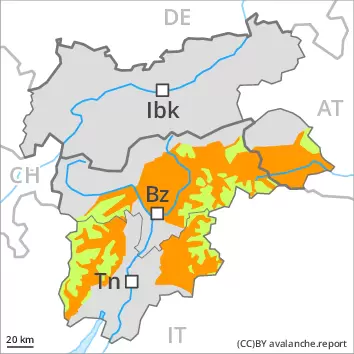
AM Danger level
2800m
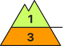
Avalanche Problem
Wet snow
2800m
PM Danger level
2800m
Avalanche Problem
Wet snow
2800m
Further increase in danger of wet and gliding avalanches in the course of the day.
The surface of the snowpack will cool hardly at all during the overcast night and will already be soft in the early morning. As the day progresses more frequent medium-sized and, in isolated cases, large wet and gliding avalanches are possible. This applies especially on steep sunny slopes below approximately 2800 m, as well as in all aspects at intermediate altitudes. Caution is to be exercised in particular in areas where the snow cover is rather shallow. Here the snowpack is weaker. Wet avalanches can be released, even by a single winter sport participant and reach dangerously large size.
Snowpack
dp.10: springtime scenario
As a consequence of mild temperatures and high relative humidity the snowpack can not consolidate during the night. The surface of the snowpack will freeze, but a strong crust will not form. This situation will give rise from the early morning to rapid and thorough wetting of the snowpack in particular on steep sunny slopes below approximately 2800 m. In areas where the snow cover is rather shallow the snowpack will soften more quickly.
The small wind slabs of the weekend are now only very rarely prone to triggering. Snow depths vary greatly, depending on the infuence of the wind. In particular in the south as well as at low and intermediate altitudes only a little snow is now lying.
Tendency
Hardly any decrease in danger of wet avalanches. The snowpack remains prone to triggering.