The early morning will see sometimes favourable avalanche conditions for a short time. The danger of wet and gliding avalanches will already increase in the late morning. As the day progresses more frequent medium-sized and, in isolated cases, large wet and gliding avalanches are possible. This applies especially on steep sunny slopes below approximately 2800 m, as well as in all aspects at intermediate altitudes. Caution is to be exercised in particular in areas where the snow cover is rather shallow. Here the snowpack is weaker. Wet avalanches can as before be released, even by a single winter sport participant and reach dangerously large size. Backcountry tours should be started early and concluded timely.
Snowpack
dp.10: springtime scenario dp.2: gliding snow
The surface of the snowpack is frozen, but not to a significant depth and will soften quickly. Sunshine and high temperatures will give rise as the day progresses to rapid and thorough wetting of the snowpack in particular on steep sunny slopes below approximately 2800 m. In areas where the snow cover is rather shallow the snowpack will soften more quickly.
The small wind slabs of the weekend are now only very rarely prone to triggering. Snow depths vary greatly, depending on the infuence of the wind. In particular in the south as well as at low and intermediate altitudes only a little snow is now lying.
Tendency
Slight decrease in danger of wet avalanches as the temperature drops.
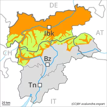
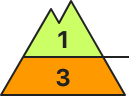
Danger level
2600m
Avalanche Problem
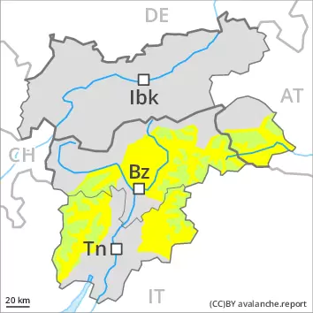
Wet snow
2600m
The avalanche conditions are spring-like.
The early morning will see quite favourable avalanche conditions for a short time. The danger of wet and gliding avalanches will already increase in the late morning. As the day progresses more frequent medium-sized wet and gliding avalanches are possible. This applies especially on steep sunny slopes below approximately 2600 m, as well as in all aspects at intermediate altitudes. Caution is to be exercised in particular in areas where the snow cover is rather shallow. Here the snowpack is weaker. Wet avalanches can as before be released, even by a single winter sport participant and reach dangerously large size. Backcountry tours should be started early and concluded timely.
Snowpack
dp.10: springtime scenario dp.2: gliding snow
The surface of the snowpack is frozen, but not to a significant depth and will soften quickly. Sunshine and high temperatures will give rise as the day progresses to rapid and thorough wetting of the snowpack in particular on steep sunny slopes below approximately 2600 m. In areas where the snow cover is rather shallow the snowpack will soften more quickly.
The small wind slabs of the weekend are now only very rarely prone to triggering. Snow depths vary greatly, depending on the infuence of the wind. In particular in the south as well as at low and intermediate altitudes only a little snow is now lying.
Tendency
Slight decrease in danger of wet avalanches as the temperature drops.