Increase in danger of moist and wet avalanches as a consequence of warming during the day and solar radiation.
The early morning will see sometimes favourable avalanche conditions for a short time. The danger of wet and gliding avalanches will already increase in the late morning. As the day progresses more frequent medium-sized and, in isolated cases, large wet and gliding avalanches are possible. This applies especially on steep sunny slopes below approximately 2600 m, as well as in all aspects at intermediate altitudes. Wet avalanches can as before be released, even by a single winter sport participant. The avalanche situation is not better in highly frequented terrain. As a consequence of warming and solar radiation, the natural activity of wet avalanches will increase. Backcountry tours should be started early and concluded timely.
Snowpack
dp.10: springtime scenario dp.2: gliding snow
The surface of the snowpack is frozen, but not to a significant depth and will soften quickly. Sunshine and high temperatures will give rise as the day progresses to rapid and thorough wetting of the snowpack in particular on steep sunny slopes below approximately 2600 m. In areas where the snow cover is rather shallow the snowpack will soften more quickly. Snow depths vary greatly, depending on the infuence of the wind. In particular in the south as well as at low and intermediate altitudes only a little snow is now lying.
Tendency
The conditions in the morning, after a clear night, are quite favourable. As a consequence of warming during the day and solar radiation more frequent medium-sized wet and gliding avalanches are possible.
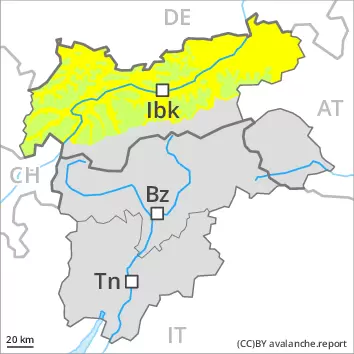
AM Danger level
2600m
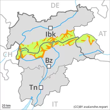
Avalanche Problem
Wet snow
2600m
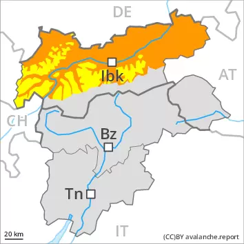
PM Danger level
2600m
Avalanche Problem
Wet snow
2600m
The danger of wet avalanches will already be elevated in the early morning.
Wet avalanches can as before be released, even by a single winter sport participant. This applies especially on steep sunny slopes below approximately 2600 m, as well as in all aspects at intermediate altitudes. As a consequence of warming, the activity of wet avalanches will increase. As the day progresses medium-sized and, in isolated cases, large wet and gliding avalanches are possible. In the regions where the outgoing longwave radiation during the night is reduced the danger will already exist in the morning. Backcountry tours should be started early and concluded timely.
Snowpack
dp.10: springtime scenario dp.2: gliding snow
Some rain fell on Saturday in some localities. Outgoing longwave radiation during the night will be reduced over a wide area. As a consequence of low stratus no crust will develop on the surface during the night. In the other regions the snowpack will only just freeze. Sunshine and high temperatures will give rise as the day progresses to rapid softening of the snowpack in particular on steep sunny slopes below approximately 2600 m. In areas where the snow cover is rather shallow the snowpack will soften more quickly. Snow depths vary greatly, depending on the infuence of the wind.
Tendency
The conditions are spring-like. Increase in danger of wet and gliding avalanches in the course of the day.
Danger level
2600m
Avalanche Problem
Wet snow
2600m
Wet small and medium sized avalanches are still possible.
Wet avalanches can in some places be released by people and reach medium size. This applies on steep east, south and west facing slopes below approximately 2600 m, as well as in all aspects at intermediate altitudes. In the regions where the outgoing longwave radiation during the night is reduced the danger will already exist in the morning. In addition further individual gliding avalanches are possible. This applies on steep grassy slopes in the regions with a lot of snow.
Snowpack
dp.10: springtime scenario
Outgoing longwave radiation during the night will be reduced in some places. As a consequence of low stratus no crust will develop on the surface during the night. In the other regions the snowpack will only just freeze. Sunshine and high temperatures will give rise as the day progresses to rapid softening of the snowpack in particular on steep sunny slopes below approximately 2600 m. In areas where the snow cover is rather shallow the snowpack will soften more quickly. Snow depths vary greatly, depending on the infuence of the wind. In particular in the south less snow than usual is lying at intermediate altitudes.
Tendency
The conditions are spring-like. Increase in danger of wet avalanches in the course of the day.