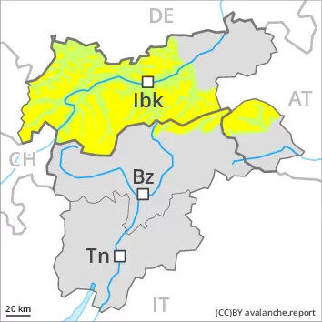
Stormy weather and new snow: Fresh wind slabs represent the main danger.
High altitudes and the high Alpine regions: The sometimes storm force wind will transport the fresh and old snow. The fresh wind slabs can be released easily in some places in particular on steep shady slopes above approximately 2200 m. The avalanche prone locations are to be found especially adjacent to ridgelines and in gullies and bowls. At elevated altitudes the avalanche prone locations are more prevalent. Avalanches can reach medium size. Especially in the regions exposed to heavier precipitation small and medium-sized dry loose snow avalanches are possible, in the event of prolonged bright spells in particular on rocky slopes.
Below the tree line: Until the early morning only isolated moist snow slides are possible. As the temperature drops there will be a rapid decrease in the danger of wet avalanches in the late morning.
Snowpack
dp.6: cold, loose snow and wind
Over a wide area 10 to 30 cm of snow, and even more in some localities, will fall above approximately 2000 m, in particular along the border with Vorarlberg, in the Allgäu Alps and in the Ammergau Alps. Down to 1000 m snow will fall from late morning over a wide area. As a consequence of sharply falling temperatures, snowfall and the strong to storm force wind, fresh snow drift accumulations will form. The wind slabs will be deposited on soft layers in particular on steep shady slopes above approximately 2200 m.
All aspects below approximately 2000 m: As a consequence of sharply falling temperatures the snowpack will consolidate.
Tendency
Fresh wind slabs represent the main danger.
Danger level
treeline
Avalanche Problem
Wind-drifted snow
Treeline
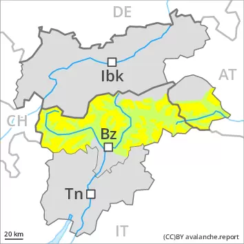
In some localities wind and new snow: Wind slabs are in some cases rather small but to be assessed with care and prudence.
As a consequence of new snow and a storm force northerly wind, further wind slabs will form from late morning. The fresh wind slabs can be released easily in some places in particular on steep shady slopes above approximately 2000 m. They are to be avoided in steep terrain. The avalanche prone locations are to be found especially adjacent to ridgelines and in gullies and bowls above approximately 2000 m. At elevated altitudes the avalanche prone locations are more prevalent and exist in all aspects.
Until the early morning only isolated wet avalanches are to be expected, in the regions exposed to rain especially. As the temperature drops there will be a rapid decrease in the danger of wet avalanches.
Snowpack
dp.6: cold, loose snow and wind
In some localities 5 to 10 cm of snow, and even more in some localities, will fall until late morning above approximately 2000 m. In some regions rain to below 2000 m. Here the snowpack is moist. As a consequence of falling temperatures a crust will form on the surface. From late morning the wind will be strong to storm force over a wide area. The small quantity of fresh snow and the wind slabs that are being formed by the strong to storm force northerly wind will be deposited on soft layers in particular on steep shady slopes above approximately 2400 m.
Tendency
Fresh wind slabs are to be evaluated with care and prudence. As a consequence of low temperatures, partly cloudy skies and the occasionally strong northerly wind, the snowpack can not consolidate on Sunday.
Danger level
2400m
Avalanche Problem
Wind-drifted snow
2400m
Fresh wind slabs represent the main danger.
As a consequence of new snow and a storm force wind, mostly small wind slabs will form. The fresh wind slabs can be released easily in some places in particular on steep shady slopes above approximately 2400 m. They are to be avoided in particular in steep terrain. The avalanche prone locations are to be found especially adjacent to ridgelines and in gullies and bowls. At elevated altitudes the avalanche prone locations are more prevalent.
Until the early morning only isolated moist snow slides are possible, in the regions exposed to rain especially. As the temperature drops there will be a rapid decrease in the danger of wet avalanches.
Snowpack
dp.6: cold, loose snow and wind
In some regions 5 to 10 cm of snow, and even more in some localities, will fall above approximately 2000 m. Rain to the tree line. Here the snowpack is moist. Down to 1000 m snow will fall from late morning. As a consequence of sharply falling temperatures, snowfall and the strong to storm force wind, fresh snow drift accumulations will form. The wind slabs will be deposited on soft layers in particular on steep shady slopes above approximately 2400 m. All aspects below approximately 2000 m: As a consequence of falling temperatures the snowpack will consolidate.
Tendency
Fresh wind slabs are to be evaluated with care and prudence. The weather conditions will foster a gradual stabilisation of the snow drift accumulations.
Danger level
2200m
Avalanche Problem
Wind-drifted snow
2200m
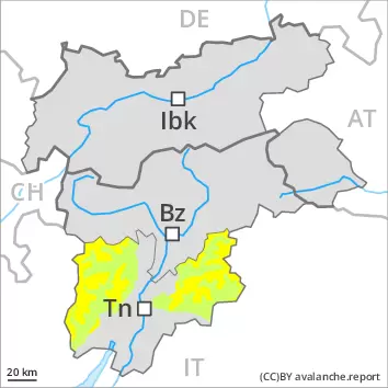
The avalanche conditions are generally favourable. Fresh wind slabs at high altitude.
As a consequence of new snow and a storm force wind, rather small wind slabs will form. The fresh wind slabs can be released by a single winter sport participant in isolated cases in particular on steep shady slopes above approximately 2200 m. The avalanche prone locations are to be found especially adjacent to ridgelines and in gullies and bowls. The wind slabs are to be avoided in particular in very steep terrain.
Until the early morning only isolated moist snow slides are possible, in the regions exposed to rain especially. As the temperature drops there will be a rapid decrease in the danger of wet avalanches in the late morning.
Snowpack
dp.6: cold, loose snow and wind
5 to 15 cm of snow, and even more in some localities, will fall above approximately 2000 m. The wind will be strong to storm force. Fresh wind slabs will be deposited on soft layers in particular on steep shady slopes above approximately 2200 m.
All aspects below approximately 2000 m: Here the snowpack is wet all the way through. As a consequence of falling temperatures the snowpack will consolidate.
Tendency
A quite favourable avalanche situation will be encountered over a wide area.
Danger level
2600m
Avalanche Problem
Wind-drifted snow
2600m
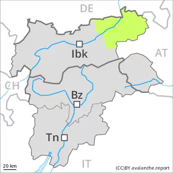
Fresh wind slabs require caution.
As a consequence of the strong northerly wind, fresh snow drift accumulations will form on Saturday. The wind slabs are mostly only small and in some cases prone to triggering. Individual avalanche prone locations are to be found in extremely steep terrain. At elevated altitudes the avalanche prone locations are more prevalent. Until the early morning only isolated moist snow slides are to be expected, in the regions exposed to rain especially. As the temperature drops there will be a rapid decrease in the danger of wet avalanches.
Snowpack
dp.6: cold, loose snow and wind
In all aspects as well as in all altitude zones only a little snow is lying. Some snow will fall until the early morning. In some regions rain. Here the snowpack is moist. As a consequence of falling temperatures a crust will form on the surface. From late morning the wind will be strong to storm force over a wide area. The small quantity of fresh snow and the wind slabs that are being formed by the strong to storm force northerly wind will be deposited on soft layers in particular on steep shady slopes above approximately 2400 m.
Tendency
Fresh wind slabs require caution.
Danger level
Avalanche Problem
Wet snow
Moist snow slides and avalanches are possible in isolated cases as before.
Moist avalanches can in some places be released easily, but they will be small in most cases. Individual avalanche prone locations are to be found in extremely steep terrain. Over a wide area from a snow sport perspective, in most cases insufficient snow is lying, especially at low and intermediate altitudes.
Snowpack
In all aspects as well as in all altitude zones only a little snow is lying. Some snow will fall until the early morning in some localities. In some regions rain. As a consequence of falling temperatures a crust will form on the surface. From late morning the wind will be strong to storm force over a wide area. The small quantity of fresh snow and the wind slabs that are being formed by the strong northerly wind will be deposited on soft layers in particular on steep shady slopes above approximately 2000 m.
Tendency
Temporary decrease in danger of wet avalanches as the temperature drops.