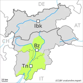
Avalanche.report

Sunday 10.04.2022

Published 09 04 2022, 17:00


Danger level

2400m
Avalanche Problem
Wind-drifted snow
2400m


Fresh wind slabs are to be evaluated with care and prudence.

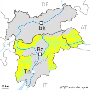
The wind slabs of the last few days are in some cases still prone to triggering. They are to be evaluated with care and prudence in particular on steep shady slopes above approximately 2400 m. The avalanche prone locations are to be found especially adjacent to ridgelines and in gullies and bowls. At elevated altitudes the avalanche prone locations are more prevalent.
On extremely steep slopes small to medium-sized loose snow avalanches are possible as a consequence of solar radiation.

Snowpack

dp.6: cold, loose snow and wind

In some regions 5 to 15 cm of snow, and even more in some localities, has fallen since Saturday. The strong wind has transported the new snow and, in some cases, old snow as well. The wind slabs are lying on soft layers in particular on steep shady slopes above approximately 2400 m. On Sunday further wind slabs will form in particular at elevated altitudes. They are mostly rather small.
As a consequence of falling temperatures the snowpack consolidated on Saturday.

Tendency

The weather conditions will foster a stabilisation of the snow drift accumulations. As a consequence of warming and solar radiation, the activity of wet avalanches will increase.


Danger level

2400m
Avalanche Problem
Wind-drifted snow
2400m


Fresh wind slabs require caution.

As a consequence of the strong northerly wind, snow drift accumulations formed on Saturday. The wind slabs are mostly only small and in some cases prone to triggering. Individual avalanche prone locations are to be found in particular in extremely steep terrain. At elevated altitudes the avalanche prone locations are more prevalent.
On extremely steep slopes small and, in isolated cases, medium-sized loose snow avalanches are possible as a consequence of solar radiation.

Snowpack

dp.6: cold, loose snow and wind

In some regions 5 to 10 cm of snow has fallen since Saturday. The strong wind has transported the new snow and, in some cases, old snow as well. The wind slabs are lying on soft layers in particular on steep shady slopes above approximately 2400 m. On Sunday further wind slabs will form in particular at elevated altitudes. They are mostly only small.
As a consequence of falling temperatures the snowpack consolidated on Saturday. In all aspects as well as in all altitude zones less snow than usual is lying.

Tendency

As a consequence of warming and solar radiation, the activity of small wet avalanches will increase.