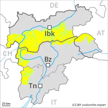
Weak layers in the old snowpack can be released in some places at elevated altitudes. As the day progresses a moderate danger of wet avalanches will prevail.
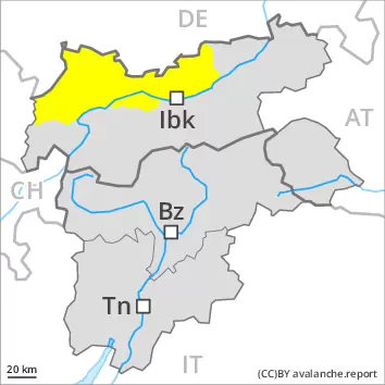
Weak layers in the upper part of the snowpack necessitate caution. Avalanches can in some cases be released, even by a single winter sport participant. The avalanche prone locations are to be found in particular on steep west, north and east facing slopes above approximately 2600 m. The avalanche prone locations are barely recognisable, even to the trained eye.
As a consequence of warming during the day and solar radiation there will be an increase in the danger of wet avalanches. This applies in particular on west, south and east facing slopes in all altitude zones, as well as on shady slopes below approximately 2400 m. In addition a certain danger of gliding avalanches exists. This applies in particular on steep grassy slopes in the regions with a lot of snow.
Backcountry tours, off-piste skiing and ascents to alpine cabins should be started early and concluded timely.
Snowpack
dp.4: cold following warm / warm following cold dp.10: springtime scenario
Isolated avalanche prone weak layers exist in the top section of the snowpack. This applies in particular on steep west, north and east facing slopes above approximately 2600 m. Towards its base, the snowpack is well consolidated.
During the night the weather will be partly cloudy. On Thursday it will be very mild. The surface of the snowpack will freeze to form a strong crust only at high altitudes and will already soften in the late morning. The spring-like weather conditions as the day progresses will give rise to a loss of strength within the snowpack. This applies on steep sunny slopes, as well as on shady slopes below approximately 2400 m. At low and intermediate altitudes only a little snow is now lying.
Tendency
Gradual decrease in danger of wet avalanches as the snowfall level drops.
AM Danger level
PM Danger level
Avalanche Problem
Wet snow
As the day progresses a moderate danger of wet avalanches will prevail.
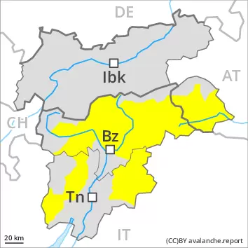
The early morning will see quite favourable conditions mostly. Individual avalanche prone locations for dry avalanches are to be found in particular on very steep west, north and east facing slopes above approximately 2600 m. This applies in particular in the north.
As a consequence of warming during the day and solar radiation there will be an increase in the danger of wet avalanches. This applies in particular on west, south and east facing slopes in all altitude zones, as well as on shady slopes below approximately 2400 m. Backcountry tours should be concluded timely.
Snowpack
dp.10: springtime scenario dp.4: cold following warm / warm following cold
Individual weak layers exist in the top section of the snowpack on steep west, north and east facing slopes. This applies in particular above approximately 2600 m. Towards its base, the snowpack is well consolidated.
During the night the weather will be partly cloudy. On Thursday it will be very mild. The surface of the snowpack will freeze to form a strong crust only at high altitudes and will already soften in the late morning. The spring-like weather conditions as the day progresses will give rise to a loss of strength within the snowpack. This applies on steep sunny slopes, as well as on shady slopes below approximately 2400 m. Only a little snow is now lying.
Tendency
The conditions remain spring-like. Gradual decrease in danger of wet avalanches as the temperature drops.
AM Danger level
PM Danger level
Avalanche Problem
Wet snow
As the day progresses a moderate danger of wet avalanches will prevail.
The early morning will see quite favourable conditions mostly. Weak layers in the upper part of the snowpack can be released in isolated cases. Individual avalanche prone locations for dry avalanches are to be found in particular on very steep west, north and east facing slopes above approximately 2600 m.
As a consequence of warming during the day and solar radiation there will be an increase in the danger of wet avalanches. This applies in particular on west, south and east facing slopes in all altitude zones, as well as on shady slopes below approximately 2200 m. Wet avalanches can in some cases release the saturated snowpack and reach dangerously large size. In addition a certain danger of gliding avalanches exists. This applies in particular on steep grassy slopes in the regions with a lot of snow.
Backcountry tours should be started early and concluded timely.
Snowpack
dp.10: springtime scenario dp.4: cold following warm / warm following cold
Individual weak layers exist in the top section of the snowpack on steep west, north and east facing slopes. This applies in particular above approximately 2600 m. Towards its base, the snowpack is well consolidated.
During the night the weather will be partly cloudy. On Thursday it will be very mild. The surface of the snowpack will freeze to form a strong crust only at high altitudes and will already soften in the late morning. The spring-like weather conditions as the day progresses will give rise to a loss of strength within the snowpack. This applies on steep sunny slopes, as well as on shady slopes below approximately 2400 m. At low and intermediate altitudes only a little snow is now lying.
Tendency
Gradual decrease in danger of wet avalanches as the snowfall level drops.
AM Danger level
PM Danger level
Avalanche Problem
Wet snow
The conditions are spring-like.
Only a little snow is now lying. The early morning will see favourable conditions generally. As a consequence of warming during the day and solar radiation moist snow slides are possible.
Snowpack
dp.10: springtime scenario
In all aspects as well as in all altitude zones only a little snow is now lying. During the night the weather will be partly cloudy. On Thursday it will be very mild. The surface of the snowpack will freeze to form a strong crust only at high altitudes and will already soften in the late morning. The spring-like weather conditions as the day progresses will give rise to significant softening of the snowpack.
Tendency
The conditions are spring-like.
AM Danger level
PM Danger level
Avalanche Problem
Wet snow
Increase in danger of wet and gliding avalanches as a consequence of warming during the day and solar radiation.
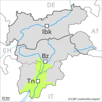
Currently there are quite favourable avalanche conditions generally. As the day progresses as a consequence of warming during the day and solar radiation there will be only a slight increase in the danger of wet snow slides. Some small and, in isolated cases, medium-sized wet loose snow avalanches are possible. In addition the danger of gliding avalanches will increase as the day progresses. Caution is to be exercised in areas with glide cracks.
Snowpack
dp.10: springtime scenario
A partly overcast night. On Thursday it will be very mild. The surface of the snowpack will only just freeze and will already soften in the late morning. The spring-like weather conditions as the day progresses will give rise to a loss of strength within the snowpack. Below the tree line only a little snow is now lying.
Tendency
Slight decrease in danger of wet avalanches as the temperature drops.