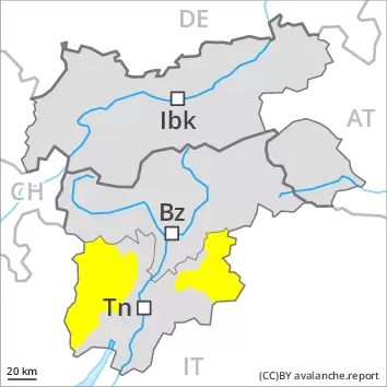
From late morning a moderate danger of gliding avalanches and wet snow slides will prevail.
The danger of gliding avalanches and wet snow slides will already be elevated in the early morning. This applies especially on very steep slopes below approximately 2500 m. As a consequence of the moist air individual small and medium-sized natural avalanches are possible. As the day progresses the likelihood of avalanches being released will increase a little. As a consequence of new snow and wind small and medium-sized moist loose snow avalanches are possible above approximately 2000 m.
Snowpack
dp.10: springtime scenario
Above approximately 2000 m snow will fall in some regions. Some rain will fall. This applies below approximately 2000 m. The surface of the snowpack will cool hardly at all during the overcast night and will already be soft in the early morning. The spring-like weather conditions as the day progresses will give rise to gradual softening of the snowpack. This applies in particular below approximately 2500 m. At low and intermediate altitudes from a snow sport perspective, in most cases insufficient snow is lying.
Tendency
Saturday: During the night the weather will be very cloudy. The weather will be mild. The avalanche danger will already be elevated in the early morning. The prevalence of avalanche prone locations and likelihood of triggering will increase as the day progresses.
Danger level
2400m
Avalanche Problem
Wet snow
2400m
From late morning a moderate danger of wet avalanches will prevail.
The danger of gliding avalanches and wet snow slides will already be elevated in the early morning. This applies especially on very steep slopes below approximately 2400 m. As a consequence of the moist air individual small and medium-sized natural avalanches are possible. As the day progresses the likelihood of avalanches being released will increase a little.
Snowpack
dp.10: springtime scenario
The surface of the snowpack will cool hardly at all during the overcast night and will already be soft in the early morning. Some rain will fall. This applies below approximately 2000 m. The weather conditions as the day progresses will give rise to gradual softening of the snowpack. This applies in particular below approximately 2400 m. At elevated altitudes the avalanche situation is generally favourable.
In all regions only a small amount of snow is lying for the time of year. At low and intermediate altitudes from a snow sport perspective, in most cases insufficient snow is lying.
Tendency
Saturday: During the night the weather will be very cloudy. The weather will be mild. The avalanche danger will already be elevated in the early morning. The prevalence of avalanche prone locations and likelihood of triggering will increase as the day progresses.
AM Danger level
PM Danger level
2600m
Avalanche Problem
Wet snow
2600m
As a consequence of warming and solar radiation a moderate danger of wet avalanches will prevail.
The early morning will see favourable conditions over a wide area. In the afternoon as a consequence of warming during the day and solar radiation there will be a gradual increase in the danger of wet avalanches, in particular below approximately 2600 m below approximately 2400 m. Backcountry tours should be started early and concluded timely.
Snowpack
dp.10: springtime scenario
During the night the weather will be clear over a wide area. The spring-like weather conditions as the day progresses will give rise to gradual softening of the snowpack. This applies in particular below approximately 2600 m. Until the evening the weather will be cloudy over a wide area.
Towards its base, the snowpack is well consolidated. In all regions only a small amount of snow is lying for the time of year. At low and intermediate altitudes from a snow sport perspective, in most cases insufficient snow is lying.
Tendency
Saturday: During the night the weather will be cloudy. The weather will be mild. The avalanche danger will already be elevated in the early morning. The prevalence of avalanche prone locations and likelihood of triggering will increase as the day progresses.
Danger level
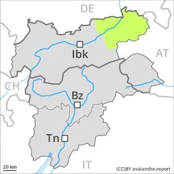
Low avalanche danger will be encountered over a wide area.
The early morning will see favourable conditions over a wide area. In the afternoon as a consequence of warming during the day and solar radiation there will be only a slight increase in the danger of wet avalanches.
Snowpack
dp.10: springtime scenario
A generally clear night. The spring-like weather conditions as the day progresses will give rise to gradual softening of the snowpack. This applies in particular below approximately 2600 m.
Towards its base, the snowpack is well consolidated. In all regions only a small amount of snow is lying for the time of year. At low and intermediate altitudes from a snow sport perspective, in most cases insufficient snow is lying.
Tendency
Low avalanche danger will be encountered over a wide area.
Danger level
Avalanche Problem
Wet snow
Wet snow slides are possible in isolated cases.
The danger of wet avalanches will already be elevated in the early morning. As the day progresses the likelihood of avalanches being released will increase a little. Individual mostly small wet avalanches are possible. This applies especially on very steep slopes. Restraint should be exercised because avalanches can sweep people along and give rise to falls.
Snowpack
dp.10: springtime scenario
The surface of the snowpack will cool hardly at all during the overcast night and will already be soft in the early morning. Some rain will fall. This applies below approximately 2000 m. The spring-like weather conditions as the day progresses will give rise to gradual softening of the snowpack. Only a little snow is now lying.
Tendency
Saturday: During the night the weather will be very cloudy. The weather will be mild. The avalanche danger will already be elevated in the early morning. The prevalence of avalanche prone locations and likelihood of triggering will increase as the day progresses.