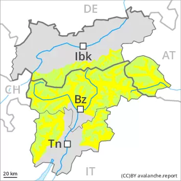
The danger of wet and gliding avalanches will already exist in the early morning, especially on very steep slopes below approximately 2400 m.
As a consequence of new snow and a strong southwesterly wind, mostly small wind slabs will form in the course of the day at high altitudes and in high Alpine regions. The fresh wind slabs can only be released in isolated cases.
Snowpack
During the night the weather will be very cloudy over a wide area. The surface of the snowpack will freeze to form a strong crust only at high altitudes. In all regions rain will fall up to 2000 m. The weather conditions will give rise to softening of the snowpack. This applies in particular below approximately 2400 m. As a consequence of snowfall above approximately 2000 m and the strong southwesterly wind, fresh snow drift accumulations will form in the course of the day. These are mostly only small. In all regions only a small amount of snow is lying for the time of year. At low and intermediate altitudes from a snow sport perspective, in most cases insufficient snow is lying.
Tendency
The danger of dry avalanches will increase. Fresh wind slabs represent the main danger. As the temperature drops there will be a decrease in the danger of wet avalanches on Sunday.
Danger level
Low avalanche danger will prevail.
As a consequence of the moist air individual moist snow slides are possible, especially on very steep shady slopes. As the day progresses the likelihood of avalanches being released will increase a little. Restraint should be exercised because avalanches can sweep people along and give rise to falls.
Snowpack
The surface of the snowpack will cool hardly at all during the overcast night and will already be soft in the early morning. Some rain will fall. This applies below approximately 2000 m. The spring-like weather conditions will give rise to softening of the snowpack. From a snow sport perspective, in most cases insufficient snow is lying.
Tendency
The danger of dry avalanches will increase, especially in high Alpine regions. As the temperature drops there will be a decrease in the danger of wet avalanches on Sunday.
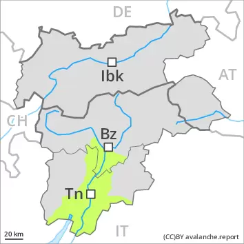
Danger level
Low avalanche danger will be encountered over a wide area.
Currently there are favourable conditions over a wide area. As a consequence of warming during the day there will be only a slight increase in the danger of moist snow slides. This applies in particular on extremely steep shady slopes at high altitude. Isolated mostly small gliding avalanches are possible on steep grassy slopes.
Snowpack
During the night the weather will be partly cloudy. The surface of the snowpack will freeze to form a strong crust only at high altitudes. The spring-like weather conditions as the day progresses will give rise to gradual moistening of the snowpack. In all regions only a small amount of snow is lying for the time of year. At low and intermediate altitudes from a snow sport perspective, in most cases insufficient snow is lying.
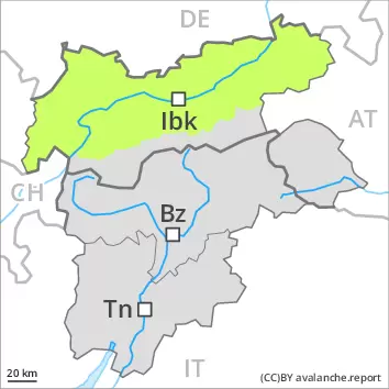
Tendency
Fresh wind slabs in the high Alpine regions. As the temperature drops there will be a decrease in the danger of moist and wet snow slides on Sunday.