Backcountry touring and other off-piste activities call for caution and restraint. Increase in danger as a consequence of the strong northwesterly wind.
As a consequence of a gathering storm force northwesterly wind, avalanche prone wind slabs will form in all aspects. These can be released even by a single winter sport participant above the tree line. Slopes adjacent to ridgelines are especially unfavourable. Individual avalanche prone locations are to be found also in areas close to the tree line. Mostly avalanches are medium-sized. The prevalence of avalanche prone locations and likelihood of triggering will increase as the day progresses. Additionally avalanches can also be released in deep layers. Such avalanche prone locations are to be found on steep, little used shady slopes above approximately 2200 m and on steep sunny slopes above approximately 2500 m.
Snowpack
dp.6: cold, loose snow and wind dp.1: deep persistent weak layer
The fresh wind slabs will be deposited on soft layers in all aspects. The more recent wind slabs will be deposited on surface hoar in some places. The snowpack will become increasingly prone to triggering. Faceted weak layers exist in the old snowpack, especially on shady slopes above approximately 2200 m, as well as on sunny slopes above approximately 2500 m. Whumpfing sounds and the formation of shooting cracks when stepping on the snowpack are a clear indication of a weakly bonded snowpack.
Tendency
Fresh wind slabs require caution. As a consequence of a strong wind from northerly directions, further wind slabs will form on Tuesday. The snowpack remains in some cases prone to triggering.
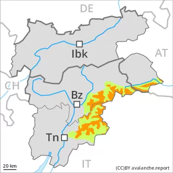
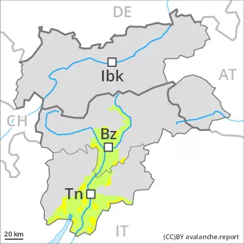
AM Danger level
treeline
Avalanche Problem
Wind slab
Treeline
Persistent weak layer
2200m
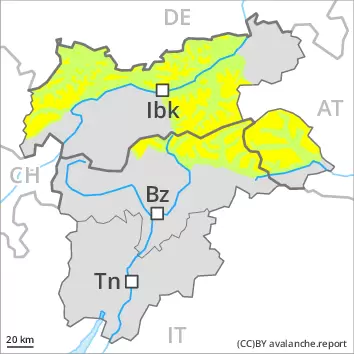
PM Danger level
treeline
Avalanche Problem
Wind slab
Treeline
Persistent weak layer
2200m
Increase in danger as a consequence of new snow and strong wind. Backcountry touring and other off-piste activities call for caution.
As a consequence of new snow and a gathering storm force northwesterly wind, avalanche prone wind slabs will form in all aspects. These can be released even by a single winter sport participant above the tree line. Slopes adjacent to ridgelines are especially unfavourable. Individual avalanche prone locations are to be found also in areas close to the tree line. Mostly avalanches are medium-sized. The prevalence of avalanche prone locations and likelihood of triggering will increase as the day progresses. Additionally avalanches can also be released in deep layers. Such avalanche prone locations are to be found on steep, little used shady slopes above approximately 2200 m and on steep sunny slopes above approximately 2500 m.
Snowpack
dp.6: cold, loose snow and wind dp.1: deep persistent weak layer
In some regions up to 10 cm of snow will fall on Monday. The fresh snow and the wind slabs that are being formed by the strong northwesterly wind will be deposited on soft layers in all aspects. The more recent wind slabs will be deposited on surface hoar in some places, in particular on the Main Alpine Ridge and to the north. The snowpack will become increasingly prone to triggering. Faceted weak layers exist in the old snowpack, especially on shady slopes above approximately 2200 m, as well as on sunny slopes above approximately 2500 m. Whumpfing sounds and the formation of shooting cracks when stepping on the snowpack are a clear indication of a weakly bonded snowpack.
Tendency
Fresh wind slabs require caution. As a consequence of a strong wind from northerly directions, further wind slabs will form on Tuesday. The snowpack remains in some cases prone to triggering.
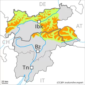
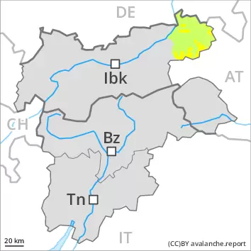
Danger level
treeline
Avalanche Problem
Wind slab
Treeline
Persistent weak layer
2200m
Increase in danger as a consequence of the strong northwesterly wind. Wind slabs and weakly bonded old snow are to be assessed with care and prudence.
As the day progresses as a consequence of the strong northwesterly wind there will be an increase in the danger within the current danger level. In all aspects avalanche prone wind slabs will form. These can be released even by a single winter sport participant above the tree line. Slopes adjacent to ridgelines are especially unfavourable. Individual avalanche prone locations are to be found also in areas close to the tree line. Mostly avalanches are medium-sized. The prevalence of avalanche prone locations and likelihood of triggering will increase as the day progresses. Additionally avalanches can also be released in deep layers. Such avalanche prone locations are to be found on steep, little used shady slopes above approximately 2200 m and on steep sunny slopes above approximately 2500 m.
Snowpack
dp.6: cold, loose snow and wind dp.1: deep persistent weak layer
Some snow will fall on Monday, in particular on the Main Alpine Ridge and to the north. The wind will transport the new snow and, in some cases, old snow as well. The fresh wind slabs will be deposited on soft layers in all aspects. They are lying on surface hoar in some places. Faceted weak layers exist in the old snowpack, especially on shady slopes above approximately 2200 m, as well as on sunny slopes above approximately 2500 m.
Tendency
Fresh wind slabs require caution. As a consequence of a strong wind from northerly directions, further wind slabs will form on Tuesday. The snowpack remains in some cases prone to triggering.
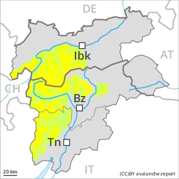
Danger level
treeline
Avalanche Problem
Wind slab
Treeline
Fresh wind slabs require caution.
As the day progresses as a consequence of the strong northwesterly wind there will be only a slight increase in the danger of dry avalanches. Adjacent to ridgelines as well as at elevated altitudes mostly small wind slabs will form. These can be released by a single winter sport participant in some cases. They are to be avoided in very steep terrain. Mostly avalanches are small.
Snowpack
dp.6: cold, loose snow and wind
As a consequence of a gathering strong northwesterly wind, mostly small wind slabs will form on Monday. The strong wind will transport the loosely bonded old snow. The fresh wind slabs will be deposited on soft layers in particular on very steep shady slopes. Hardly any weak layers exist in the old snowpack.
Tendency
The wind slabs are bonding only slowly with the old snowpack in particular on very steep shady slopes.
Danger level
1800m
Avalanche Problem
Wind slab
1800m
Increase in avalanche danger as a consequence of the strong to storm force northwesterly wind. Fresh wind slabs represent the main danger.
As the day progresses as a consequence of the strong to storm force northwesterly wind there will be an increase in the avalanche danger within the current danger level. In all aspects avalanche prone wind slabs will form. These can be released even by a single winter sport participant above approximately 1800 m. Slopes adjacent to ridgelines are especially unfavourable. Avalanche prone locations are to be found also in areas close to the tree line. Mostly avalanches are medium-sized. The prevalence of avalanche prone locations and likelihood of triggering will increase as the day progresses.
Snowpack
dp.6: cold, loose snow and wind
Some snow will fall on Monday. The wind will transport the new snow and, in some cases, old snow as well. The fresh wind slabs will be deposited on soft layers in all aspects. They are lying on surface hoar in some places.
Tendency
Fresh wind slabs require caution. As a consequence of a strong wind from northerly directions, further wind slabs will form on Tuesday. The snowpack remains in some cases prone to triggering.