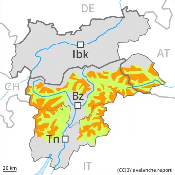
The new snow and wind slabs can be released easily.
The fresh snow and the wind slabs formed by the wind can be released by a single winter sport participant. The avalanche prone locations are to be found in all aspects above approximately 1600 m, caution is to be exercised in particular in gullies and bowls, and behind abrupt changes in the terrain. The avalanche prone locations are sometimes covered with new snow and are difficult to recognise. Their prevalence will increase with altitude. Avalanches can in many cases reach medium size. On extremely steep slopes more loose snow avalanches are to be expected. Gliding avalanches can also occur, especially on steep grassy slopes in the regions exposed to heavier precipitation. Experience and restraint are required.
Snowpack
dp.6: cold, loose snow and wind dp.2: gliding snow
In some localities up to 15 cm of snow will fall on Sunday. The snowpack will be in most cases prone to triggering. New snow and wind slabs are lying mostly on soft layers, in particular at elevated altitudes. In some cases the various wind slabs have bonded poorly together. Isolated whumpfing sounds and shooting cracks when stepping on the snowpack indicate the unfavourable bonding of the snowpack on very steep slopes.
Tendency
Monday: As the snowfall eases there will be a decrease in the danger of dry avalanches within the current danger level. The weather conditions will bring about a gradual strengthening of the snowpack.
Danger level
treeline
Avalanche Problem
New snow
Treeline
Persistent weak layer
2400m
Gliding snow
2400m
New snow represents the main danger. Weakly bonded old snow at elevated altitudes.
The large quantity of fresh snow of the last few days and the sometimes large wind slabs can be released easily, even by a single winter sport participant,. The avalanche prone locations are to be found in steep terrain above the tree line. Caution is to be exercised in gullies and bowls, and behind abrupt changes in the terrain. The avalanche prone locations are sometimes covered with new snow and are difficult to recognise. The number and size of avalanche prone locations will increase with altitude. In isolated cases avalanches can also release deeper layers of the snowpack and reach large size, especially on very steep west, north and east facing slopes above approximately 2400 m. On extremely steep slopes more loose snow avalanches are to be expected, even medium-sized ones, in the event of prolonged bright spells in particular. In addition in particular in the regions exposed to heavier precipitation, gliding avalanches are possible, especially on steep grassy slopes at intermediate and high altitudes. Caution and restraint are required.
Snowpack
dp.6: cold, loose snow and wind dp.4: cold following warm / warm following cold
5 to 15 cm of snow, and even more in some localities, will fall until late in the night. On Sunday the wind will be strong in some cases in particular on the Main Alpine Ridge and to the south. The snowpack will be prone to triggering. In some places new snow and wind slabs are lying on soft layers. The various wind slabs have bonded poorly together, in particular at elevated altitudes. Faceted weak layers exist in the old snowpack on very steep west, north and east facing slopes, especially above approximately 2400 m on the Main Alpine Ridge. Whumpfing sounds and the formation of shooting cracks when stepping on the snowpack indicate the unfavourable bonding of the snowpack in the regions exposed to substantial precipitation.
Tendency
Monday: As the snowfall eases there will be a decrease in the danger of dry avalanches within the current danger level. The weather conditions will bring about a gradual strengthening of the snowpack.
Danger level
2200m
Avalanche Problem
Wind slab
2200m
Wind slabs represent the main danger.
The fresh wind slabs can be released easily in some places on very steep west, north and east facing slopes above approximately 2200 m. In high Alpine regions the avalanche prone locations are a little more prevalent and exist in all aspects. Avalanche prone locations are to be found in gullies and bowls, and behind abrupt changes in the terrain. Fresh wind slabs are to be bypassed as far as possible. Mostly avalanches are medium-sized. As a consequence of solar radiation more small and, in isolated cases, medium-sized loose snow avalanches are possible, especially on extremely steep sunny slopes. In addition in particular in the regions exposed to heavier precipitation, individual gliding avalanches are possible.
Snowpack
dp.6: cold, loose snow and wind dp.2: gliding snow
On Sunday the wind will be strong in some cases in the regions exposed to the foehn wind. The wind will transport the new snow. The snowpack will be prone to triggering in some places. The various wind slabs have bonded poorly together, in particular on shady slopes at elevated altitudes. Isolated avalanche prone weak layers exist in the old snowpack on very steep shady slopes, especially at elevated altitudes.
Tendency
Monday: The weather conditions will bring about a gradual strengthening of the snow drift accumulations.
Danger level
2200m
Avalanche Problem
Wind slab
2200m
Fresh wind slabs require caution.
The fresh wind slabs can still be released in some cases. The avalanche prone locations are to be found in particular on very steep shady slopes above approximately 2200 m. Caution is to be exercised adjacent to ridgelines and in gullies and bowls. Avalanches can reach medium size in isolated cases. On extremely steep slopes individual wet loose snow slides are possible, in the event of solar radiation in particular.
Snowpack
dp.6: cold, loose snow and wind
In some places wind slabs are lying on soft layers, in particular on steep shady slopes at elevated altitudes. In some cases the various wind slabs have bonded still only poorly together. Sunshine and high temperatures will give rise as the day progresses to gradual moistening of the snowpack.
Tendency
Monday: The weather conditions fostered a strengthening of the snow drift accumulations. They are now only very rarely prone to triggering.