Weakly bonded old snow represents the main danger. Fresh wind slabs are to be evaluated with care and prudence.
Weakly bonded old snow is to be evaluated critically, in particular on steep shady slopes above approximately 2400 m. Avalanches can sometimes be released, even by a single winter sport participant and reach large size.
Increase in danger of dry avalanches as a consequence of new snow and wind. The fresh wind slabs are in some cases quite large and prone to triggering, in particular on steep shady slopes above approximately 2400 m. Avalanches can penetrate deep layers.
Afternoon: As a consequence of solar radiation more frequent loose snow avalanches are to be expected, especially on extremely steep sunny slopes.
Decrease in danger of moist and wet avalanches as the temperature drops.
Snowpack
dp.4: cold following warm / warm following cold dp.6: cold, loose snow and wind
20 to 30 cm of snow will fall on Monday above approximately 2000 m. As a consequence of new snow and a sometimes strong northwesterly wind, sometimes large wind slabs will form. Avalanche prone weak layers exist in the top section of the snowpack in particular on steep shady slopes.
Tendency
The meteorological conditions will facilitate a slow stabilisation of the snowpack.
Danger level
2000m
Avalanche Problem
Wet snow
2000m
Wind slab
2000m
Wet snow represents the main danger.
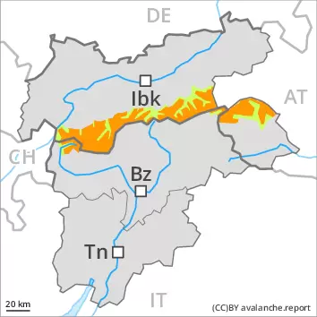
Up to 2000 m rain will fall until the early morning over a wide area. Some snow will fall during the night. As a consequence of the precipitation more frequent medium-sized and, in isolated cases, large moist and wet avalanches are possible. The wind slabs of the last few days can be released by a single winter sport participant. Avalanche prone locations are to be found in gullies and bowls, and behind abrupt changes in the terrain. The wind slabs are to be bypassed as far as possible.
Snowpack
dp.10: springtime scenario
Over a wide area 5 to 10 cm of snow, and even more in some localities, will fall until the early morning. The spring-like weather conditions will give rise to rapid moistening of the snowpack in particular on steep sunny slopes. The sometimes new snow-covered wind slabs of the last few days remain for the foreseeable future prone to triggering at high altitude.
Tendency
Medium-sized natural avalanches are likely.
Danger level
2400m
Avalanche Problem
Persistent weak layer
2400m
Wind slab
2400m
Weakly bonded old snow requires caution. Fresh wind slabs are to be evaluated with care and prudence.
Weakly bonded old snow is to be evaluated critically, in particular on steep shady slopes above approximately 2400 m.
Slight increase in danger of dry avalanches as a consequence of new snow and wind. The fresh wind slabs are mostly rather small but in some cases prone to triggering, in particular on steep shady slopes above approximately 2400 m. Avalanches can in isolated cases be released in near-surface layers and reach large size in isolated cases in particular in the regions with a lot of snow.
Afternoon: As a consequence of solar radiation individual loose snow avalanches are to be expected, especially on extremely steep sunny slopes.
Decrease in danger of moist and wet avalanches as the temperature drops.
Snowpack
dp.4: cold following warm / warm following cold dp.6: cold, loose snow and wind
5 to 15 cm of snow will fall on Monday above approximately 2000 m. As a consequence of new snow and a sometimes strong northwesterly wind, rather small wind slabs will form. Avalanche prone weak layers exist in the top section of the snowpack in particular on steep shady slopes.
Tendency
The meteorological conditions will facilitate a slow stabilisation of the snowpack.
Danger level
2400m
Avalanche Problem
Persistent weak layer
2400m
Wind slab
2400m
Weakly bonded old snow requires caution. Fresh wind slabs are to be evaluated with care and prudence.
Weakly bonded old snow is to be evaluated critically, in particular on steep shady slopes above approximately 2400 m. Slight increase in danger of dry avalanches as a consequence of new snow and wind. The fresh wind slabs are mostly rather small but in some cases prone to triggering, in particular on steep shady slopes above approximately 2400 m. Avalanches can in isolated cases be released in near-surface layers and reach large size in isolated cases in particular in the regions with a lot of snow.
Afternoon: As a consequence of solar radiation individual loose snow avalanches are to be expected.
Decrease in danger of moist and wet avalanches as the temperature drops.
Snowpack
dp.4: cold following warm / warm following cold dp.6: cold, loose snow and wind
5 to 15 cm of snow will fall on Monday above approximately 2000 m. As a consequence of new snow and a sometimes strong northwesterly wind, rather small wind slabs will form. Avalanche prone weak layers exist in the top section of the snowpack in particular on steep shady slopes.
Tendency
The meteorological conditions will facilitate a slow stabilisation of the snowpack.
Danger level
Avalanche Problem
Wet snow
Wet snow represents the main danger.
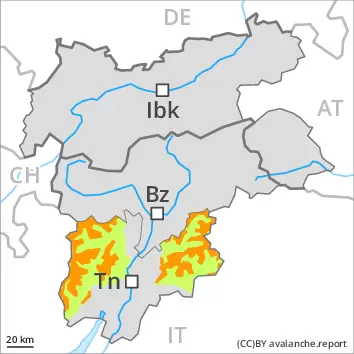
Up to 2000 m rain will fall until the early morning over a wide area. Some snow will fall during the night. As a consequence of the precipitation more frequent medium-sized moist and wet avalanches are possible.
Snowpack
dp.10: springtime scenario
Over a wide area 5 to 10 cm of snow, and even more in some localities, will fall until the early morning. The spring-like weather conditions will give rise to rapid moistening of the snowpack in particular on steep sunny slopes. In all regions at low and intermediate altitudes only a little snow is lying.
Tendency
Medium-sized natural avalanches are likely.
Danger level
Low avalanche danger will prevail.
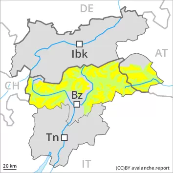
Fresh wind slabs require caution, in particular on very steep shady slopes at high altitude. Apart from the danger of being buried, restraint should be exercised in particular in view of the danger of avalanches sweeping people along and giving rise to falls.
Snowpack
dp.6: cold, loose snow and wind
Some snow will fall, especially at high altitude. At low and intermediate altitudes hardly any snow is lying.
Tendency
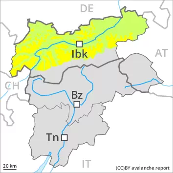
Low avalanche danger will prevail. From a snow sport perspective, in most cases insufficient snow is lying.