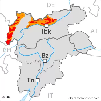
Large quantities of fresh snow and the wind-drifted snow are prone to triggering. Weakly bonded old snow above approximately 2400 m.
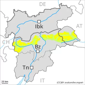
As a consequence of snowfall and the strong to storm force northwesterly wind, a critical avalanche situation will develop. The danger exists in particular in alpine snow sports terrain. An increasing number of natural avalanches are to be expected as the snowfall becomes more intense, this applies especially during the course of the night. The fresh snow and the extensive wind slabs that are forming over a wide area can be released very easily above the tree line. Caution is to be exercised also in areas close to the tree line. Additionally avalanches can also be triggered in the old snowpack and reach large size. Such avalanche prone locations are to be found on steep slopes of all aspects above approximately 2400 m. The off-piste conditions remain critical.
Gliding avalanches can also occur. In the regions exposed to heavier precipitation this applies in particular on very steep grassy slopes.
Snowpack
dp.6: cold, loose snow and wind dp.4: cold following warm / warm following cold
Over a wide area 40 to 50 cm of snow will fall in the next few hours. 80 to 100 cm of snow has fallen since Friday. The new snow and wind slabs are prone to triggering above the tree line. This also applies in areas close to the tree line. The new snow and wind slabs will be deposited on soft layers on wind-protected shady slopes at elevated altitudes. Faceted weak layers exist in the centre of the snowpack. This applies on steep shady slopes above approximately 2400 m, as well as on steep sunny slopes above approximately 2800 m. Shooting cracks when stepping on the snowpack and released avalanches confirm the unfavourable bonding of the snowpack.
Tendency
Outside marked and open pistes a critical avalanche situation will persist.
Danger level
treeline
Avalanche Problem
New snow
Treeline
Persistent weak layer
2400m
New snow
Treeline
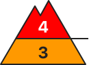
New snow and wind slabs represent the main danger. Weakly bonded old snow above approximately 2400 m.
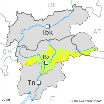
As a consequence of snowfall and the strong to storm force northwesterly wind, a critical avalanche situation will develop. The fresh snow and the extensive wind slabs that are forming over a wide area can be released easily or naturally above the tree line. Also slopes close to the tree line are unfavourable. Additionally avalanches can also be triggered in the old snowpack and reach large size. Such avalanche prone locations are to be found on steep slopes of all aspects above approximately 2400 m. The off-piste conditions are critical.
Snowpack
dp.6: cold, loose snow and wind dp.4: cold following warm / warm following cold
Over a wide area 40 to 80 cm of snow fell in the last few days. The new snow and wind slabs are prone to triggering above the tree line. The new snow and wind slabs will be deposited on soft layers on wind-protected shady slopes at elevated altitudes. Faceted weak layers exist in the centre of the snowpack. This applies in particular on steep shady slopes above approximately 2400 m, as well as on steep sunny slopes above approximately 2800 m. Shooting cracks when stepping on the snowpack and released avalanches confirm the unfavourable bonding of the snowpack.
Tendency
The conditions remain critical.
Danger level
treeline
Avalanche Problem
New snow
Treeline
New snow
Treeline
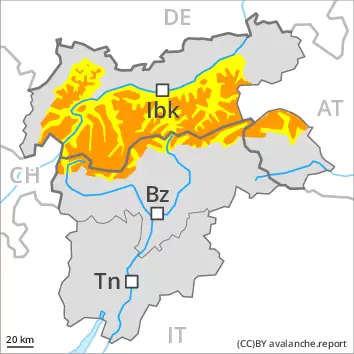
New snow and wind slabs represent the main danger.
The fresh snow and the extensive wind slabs that are forming over a wide area can be released easily or naturally above the tree line. Individual avalanche prone locations are to be found also in areas close to the tree line. The off-piste conditions are critical.
Snowpack
dp.6: cold, loose snow and wind
Over a wide area 20 to 30 cm of snow will fall in the next few hours. This also applies in areas close to the tree line. The new snow and wind slabs are prone to triggering above the tree line. Large quantities of fresh snow and the wind-drifted snow will be deposited on soft layers on wind-protected shady slopes at elevated altitudes.
Tendency
The weather effects will prevent a decrease in the avalanche danger.
Danger level
treeline
Avalanche Problem
Wind slab
Treeline
Persistent weak layer
2400m
Fresh wind slabs require caution.
As a consequence of new snow and a storm force northwesterly wind, avalanche prone wind slabs formed on Saturday especially in gullies and bowls and behind abrupt changes in the terrain. The brittle wind slabs can be released even by a single winter sport participant in all aspects at high altitudes and in high Alpine regions. In regions neighbouring those that are subject to danger level 3 (considerable) the avalanche prone locations are more prevalent. Weakly bonded old snow: In isolated cases avalanches can be released in deep layers of the snowpack and reach quite a large size, especially on steep shady slopes in high Alpine regions. Apart from the danger of being buried, restraint should be exercised as well in view of the danger of avalanches sweeping people along and giving rise to falls. The Avalanche Warning Service currently has only a small amount of information, so that the avalanche danger should be investigated especially thoroughly in the relevant locality.
Snowpack
dp.6: cold, loose snow and wind dp.1: deep persistent weak layer
Over a wide area 10 to 20 cm of snow, and even more in some localities, fell on Saturday. The new snow and wind slabs are prone to triggering above the tree line. The new snow and wind slabs will be deposited on soft layers on wind-protected shady slopes at elevated altitudes. Faceted weak layers exist in the snowpack in particular above approximately 2400 m.
Tendency
The weather effects will prevent a decrease in the avalanche danger. Fresh wind slabs represent the main danger.
Danger level
2400m
Avalanche Problem
Wind slab
2400m
Fresh wind slabs are to be evaluated with care and prudence.
As a consequence of a storm force northwesterly wind, clearly visible wind slabs formed on Saturday especially in gullies and bowls and behind abrupt changes in the terrain. The mostly small wind slabs can be released even by a single winter sport participant especially on very steep shady slopes at high altitudes and in high Alpine regions. The avalanche prone locations are rather rare. In the north the avalanche prone locations are a little more prevalent. Restraint should be exercised because avalanches can sweep people along and give rise to falls. The Avalanche Warning Service currently has only a small amount of information, so that the avalanche danger should be investigated especially thoroughly in the relevant locality.
Snowpack
dp.6: cold, loose snow and wind
From a snow sport perspective, in most cases insufficient snow is lying. As a consequence of sharply falling temperatures a crust formed on the surface, in particular on steep sunny slopes in all altitude zones, as well as on shady slopes below approximately 2400 m.