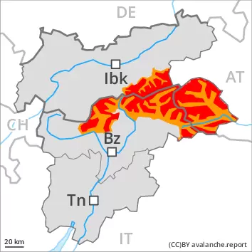
Significant increase in avalanche danger as a consequence of new snow and strong wind.
A very large quantity of fresh snow and the sometimes large wind slabs that are forming during the snowfall can be released easily or naturally in all aspects above the tree line. Individual large natural avalanches are to be expected, especially in case of releases originating from very steep high-altitude leeward starting zones. The avalanche prone locations are sometimes covered with new snow and are barely recognisable, even to the trained eye. Avalanches can also be triggered in the old snowpack and reach quite a large size in particular on very steep west, north and east facing slopes. Such avalanche prone locations are to be found in particular above approximately 2400 m.
On steep grassy slopes medium-sized gliding avalanches are possible as a consequence of the new snow, especially on sunny slopes below approximately 2400 m.
Backcountry touring and other off-piste activities call for experience in the assessment of avalanche danger and restraint.
Snowpack
dp.6: cold, loose snow and wind dp.2: gliding snow
Up to 50 cm of snow, and even more in some localities, will fall on Friday above approximately 1500 m. The strong wind will transport the new snow significantly.
Especially shady slopes above approximately 2400 m: The new snow and wind slabs are lying on soft layers.
The old snowpack remains subject to considerable local variations at high altitude. Within the snowpack, there are multiple melt-freeze crusts sandwiches with faceted layers in between, in particular on steep sunny slopes in all altitude zones, as well as on shady slopes below approximately 2600 m.
Tendency
With the end of the snowfall, the natural activity of slab avalanches will slowly decrease. More frequent loose snow avalanches are to be expected as the day progresses, in particular medium-sized ones, in the event of solar radiation especially on extremely steep sunny slopes. The activity of gliding avalanches will increase, in particular on steep east, south and west facing slopes below approximately 2400 m.
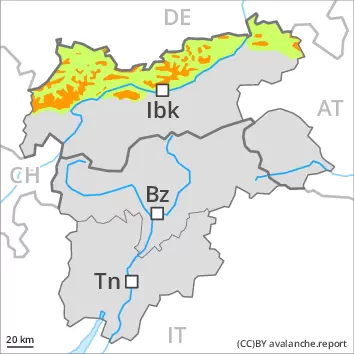
Danger level
treeline
Avalanche Problem
New snow
Treeline
Persistent weak layer
2400m
Gliding snow
2400m
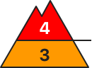
Significant increase in avalanche danger as a consequence of new snow and strong wind.
The large quantity of fresh snow and the sometimes large wind slabs that are forming during the snowfall can be released easily or naturally in all aspects above the tree line. Medium-sized natural avalanches are to be expected, especially in case of releases originating from very steep high-altitude leeward starting zones. The avalanche prone locations are sometimes covered with new snow and are barely recognisable, even to the trained eye. Avalanches can also be triggered in the old snowpack and reach quite a large size in particular on very steep west, north and east facing slopes. Such avalanche prone locations are to be found in particular above approximately 2400 m.
On steep grassy slopes medium-sized gliding avalanches are possible as a consequence of the new snow, especially on sunny slopes below approximately 2400 m.
Backcountry touring and other off-piste activities call for experience in the assessment of avalanche danger and restraint.
Snowpack
dp.6: cold, loose snow and wind dp.2: gliding snow
Over a wide area 20 to 40 cm of snow will fall on Friday above approximately 1500 m. The strong wind will transport the new snow significantly.
Especially shady slopes above approximately 2400 m: The new snow and wind slabs are lying on soft layers.
The old snowpack remains subject to considerable local variations at high altitude. Within the snowpack, there are multiple melt-freeze crusts sandwiches with faceted layers in between, in particular on steep sunny slopes in all altitude zones, as well as on shady slopes below approximately 2600 m.
Tendency
With the end of the snowfall, the natural activity of slab avalanches will slowly decrease. More frequent loose snow avalanches are to be expected as the day progresses, in particular medium-sized ones, in the event of solar radiation especially on extremely steep sunny slopes. The activity of gliding avalanches will increase, in particular on steep east, south and west facing slopes below approximately 2400 m.
Danger level
treeline
Avalanche Problem
Wind slab
Treeline
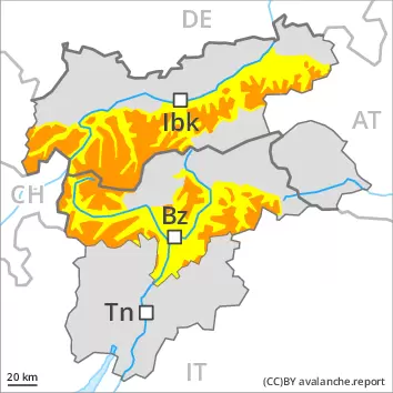
Increase in avalanche danger as a consequence of new snow and strong wind. Fresh wind slabs require caution.
The fresh snow and the wind slabs that are forming during the snowfall are to be evaluated with care and prudence in particular on west to north to east facing aspects above the tree line. Avalanches can in many places be released, even by a single winter sport participant and reach medium size.
On steep grassy slopes medium-sized gliding avalanches are possible as a consequence of the new snow, especially on sunny slopes below approximately 2400 m.
Snowpack
dp.6: cold, loose snow and wind dp.2: gliding snow
20 cm of snow, and even more in some localities, will fall on Friday. The strong wind will transport the new snow significantly. The new snow and wind slabs will be deposited on soft layers in particular on west to north to east facing aspects above approximately 2200 m.
The old snowpack remains subject to considerable local variations at high altitude. Within the snowpack, there are multiple melt-freeze crusts sandwiches with faceted layers in between, in particular on steep sunny slopes in all altitude zones, as well as on shady slopes below approximately 2600 m.
Tendency
The fresh wind slabs remain prone to triggering. More frequent loose snow avalanches are to be expected as the day progresses, even medium-sized ones, in the event of solar radiation especially on extremely steep sunny slopes. The activity of gliding avalanches will increase, in particular on steep east, south and west facing slopes below approximately 2400 m.
Danger level
1500m
Avalanche Problem
New snow
1500m
Wind slab
Treeline
Significant increase in avalanche danger as a consequence of new snow and strong wind.
The large quantity of fresh snow and the sometimes large wind slabs that are forming during the snowfall can be released easily or naturally in all aspects at intermediate and high altitudes. Medium-sized natural avalanches are to be expected, especially in case of releases originating from very steep leeward starting zones. The avalanche prone locations are covered with new snow and are barely recognisable, even to the trained eye. Avalanches can also be triggered in the old snowpack and reach quite a large size in particular on very steep west, north and east facing slopes. On steep grassy slopes medium-sized gliding avalanches are possible as a consequence of the new snow. Backcountry touring and other off-piste activities call for extensive experience in the assessment of avalanche danger and great restraint.
Snowpack
dp.6: cold, loose snow and wind
Over a wide area 30 to 60 cm of snow, and even more in some localities, will fall on Friday above approximately 1500 m. The strong wind will transport the new snow. The new snow and wind slabs are lying on a crust in all aspects below approximately 2400 m. Especially shady slopes above approximately 2400 m: The new snow and wind slabs are bonding poorly with the old snowpack in all aspects. The old snowpack remains subject to considerable local variations at high altitude.
Tendency
Numerous loose snow avalanches are to be expected as the day progresses, but they can be quite large, in the regions exposed to a lot of new snow especially on very steep slopes. The natural activity of slab avalanches will slowly decrease.