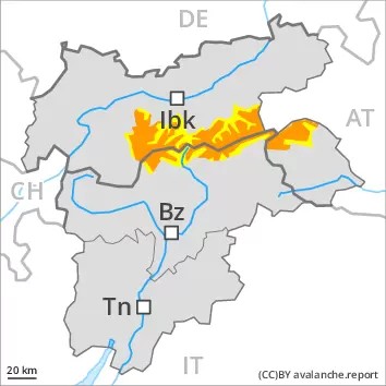
New snow and weakly bonded old snow represent the main danger.
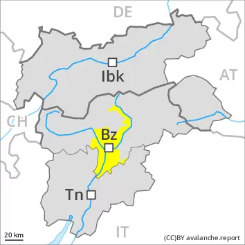
The avalanche danger in particular at elevated altitudes is within the uppermost range of danger level 3 (considerable). A very large quantity of fresh snow and the sometimes large wind slabs that are being formed by the strong to storm force southerly wind can be released very easily in all aspects above approximately 2200 m. Individual occasionally large natural avalanches are possible, especially in case of releases originating from very steep high-altitude shady starting zones. Avalanches can also be triggered in the old snowpack and reach large size in particular on very steep west, north and east facing slopes. Such avalanche prone locations are to be found in particular above approximately 2400 m.
On steep grassy slopes medium-sized gliding avalanches are possible as a consequence of the new snow, especially on sunny slopes below approximately 2400 m.
Backcountry touring and other off-piste activities call for great caution and restraint.
Snowpack
dp.6: cold, loose snow and wind dp.4: cold following warm / warm following cold
Up to 70 cm of snow fell on Friday above approximately 1500 m. Up to 10 cm of snow will fall on Sunday. The southerly wind will transport the new snow significantly. In some cases new snow and wind slabs are lying on a weakly bonded old snowpack, in particular on steep west and east facing slopes above approximately 2400 m, as well as on steep north facing slopes above approximately 2200 m.
Tendency
The weather conditions will prevent a rapid stabilisation of the near-surface layers. The danger of gliding avalanches will persist, in particular on steep east, south and west facing slopes below approximately 2400 m.
Danger level
1500m
Avalanche Problem
New snow
1500m
Wind slab
Treeline
Gliding snow
2000m
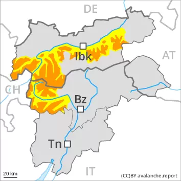
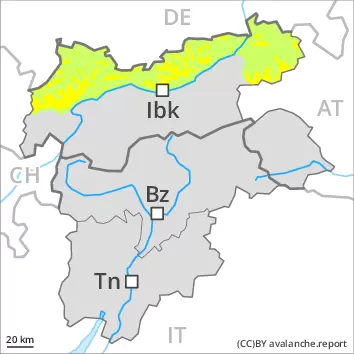
The fresh snow and the wind slabs represent the main danger. Loose snow avalanches are to be expected.
The large quantity of fresh snow and the sometimes deep wind slabs can be released easily or naturally in all aspects. As a consequence of the moderate to strong southwesterly wind the avalanche prone locations will become more prevalent. Medium-sized and, in isolated cases, large natural avalanches are to be expected, especially in case of releases originating from very steep leeward starting zones. The avalanche prone locations are covered with new snow and are barely recognisable, even to the trained eye. An increasing number of medium-sized and, in isolated cases, large loose snow avalanches are to be expected as the day progresses, in the event of prolonged bright spells especially. Avalanches can also be triggered in the old snowpack and reach quite a large size. On steep grassy slopes medium-sized gliding avalanches are possible. Backcountry touring and other off-piste activities call for great caution and restraint.
Snowpack
dp.6: cold, loose snow and wind
Over a wide area 25 to 50 cm of snow, and even more in some localities, has fallen since Friday above approximately 1400 m. The strong wind has transported some snow. The new snow and wind slabs are lying on a crust in all aspects below approximately 2400 m. The new snow and wind slabs are poorly bonded with the old snowpack. Especially shady slopes above approximately 2400 m:
Tendency
Loose snow avalanches are possible, but they can be quite large, in the regions exposed to a lot of new snow especially on very steep slopes. The weather conditions will prevent a rapid stabilisation of the near-surface layers.
Danger level
2400m
Avalanche Problem
Persistent weak layer
2400m
Wind slab
Treeline
Gliding snow
2400m
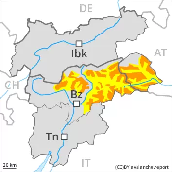
Weakly bonded old snow represents the main danger. Fresh wind slabs require caution.
Avalanches can be triggered in the old snowpack and reach large size in isolated cases in particular on very steep west, north and east facing slopes. Such avalanche prone locations are to be found above approximately 2400 m.
Above the tree line the wind slabs will increase in size additionally. Even single winter sport participants can release avalanches, including medium-sized ones, especially on steep shady slopes. The number and size of avalanche prone locations will increase with altitude.
On steep grassy slopes medium-sized gliding avalanches are possible, especially on sunny slopes below approximately 2400 m.
Snowpack
dp.4: cold following warm / warm following cold dp.6: cold, loose snow and wind
Over a wide area 20 to 40 cm of snow, and even more in some localities, has fallen above approximately 1500 m. As a consequence of the sometimes strong wind the wind slabs will increase in size additionally.
In some cases new snow and wind slabs are lying on a weakly bonded old snowpack, in particular on steep west, north and east facing slopes above approximately 2400 m.
Tendency
The conditions will prevent a rapid stabilisation of the snowpack. In addition further gliding avalanches are to be expected. Some loose snow avalanches are possible, in the event of prolonged bright spells in particular on extremely steep slopes.
Danger level
2400m
Avalanche Problem
Persistent weak layer
2400m
New snow
Treeline
Gliding snow
2400m
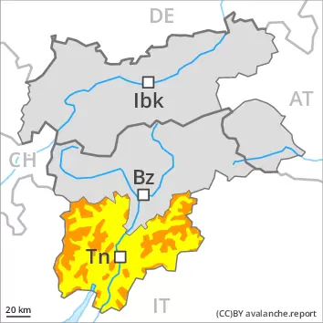
Weakly bonded old snow requires caution. Loose snow avalanches and gliding avalanches are still possible.
Weak layers in the old snowpack can be released in some places even by individual winter sport participants. The avalanche prone locations are to be found in particular on west, north and east facing slopes above approximately 2400 m. Avalanches can reach large size in isolated cases. Fresh avalanches and whumpfing sounds serve as an alarm indicating the danger.
In addition the wind slabs of the last few days are capable of being triggered in some cases. Such avalanche prone locations are to be found in particular on very steep shady slopes above the tree line, caution is to be exercised in particular adjacent to ridgelines and in pass areas. These places are sometimes covered with new snow and are therefore difficult to recognise.
As the day progresses more small and medium-sized loose snow avalanches are possible, in the event of solar radiation especially. On steep grassy slopes small and medium-sized gliding avalanches are possible as a consequence of the new snow, especially on sunny slopes below approximately 2400 m.
Backcountry touring and other off-piste activities call for careful route selection.
Snowpack
dp.4: cold following warm / warm following cold dp.2: gliding snow
5 to 10 cm of snow will fall on Sunday. The wind will be moderate adjacent to ridgelines.
The new snow and wind slabs of Friday are lying on the unfavourable surface of an old snowpack in particular on west to north to east facing aspects above approximately 2400 m. Fresh wind slabs are lying on soft layers on near-ridge shady slopes. Somewhat older wind slabs are covered with new snow and therefore barely recognisable.
Tendency
Weakly bonded old snow represents the main danger. The danger of gliding avalanches will persist.
Danger level
Avalanche Problem
Gliding snow
Wind slab
Treeline
Individual avalanche prone locations for dry avalanches are to be found in particular on very steep shady slopes. In addition gliding avalanches and snow slides are possible.
The new snow and wind slabs of Friday can be released by a single winter sport participant in isolated cases in particular on very steep shady slopes above the tree line, caution is to be exercised in particular adjacent to ridgelines and in pass areas. These places are sometimes covered with new snow and are therefore difficult to recognise. Mostly avalanches are only small.
As the day progresses mostly small loose snow avalanches are possible, in the event of solar radiation especially. On steep grassy slopes small to medium-sized gliding avalanches are possible as a consequence of the new snow. Caution is to be exercised in areas with glide cracks.
Snowpack
dp.6: cold, loose snow and wind dp.2: gliding snow
Some snow will fall on Sunday. The wind will be moderate adjacent to ridgelines.
The fresh and older wind slabs are lying on soft layers on near-ridge shady slopes.
The solar radiation will give rise as the day progresses to moistening of the snowpack in particular on sunny slopes. Only a little snow is lying.
Tendency
Individual gliding avalanches and snow slides are possible, but they will be mostly small. Wind slabs are now only very rarely prone to triggering.
Danger level
treeline
Avalanche Problem
Wind slab
Treeline
Fresh wind slabs require caution.
In the last few days clearly visible wind slabs formed. Avalanches can in some places be released by a single winter sport participant and reach medium size, in particular on steep shady slopes. The prevalence of avalanche prone locations and likelihood of triggering will increase with altitude.
As the day progresses more frequent small and, in isolated cases, medium-sized loose snow avalanches are to be expected, in the event of prolonged bright spells especially on extremely steep slopes. On steep grassy slopes mostly small gliding avalanches are possible, in particular on sunny slopes below approximately 2400 m.
Snowpack
dp.6: cold, loose snow and wind dp.2: gliding snow
20 cm of snow, and even more in some localities, fell on Friday. The sometimes strong wind has transported the new snow. In some cases wind slabs are lying on soft layers, in particular on steep shady slopes above the tree line.
Tendency
The wind slabs are in some cases prone to triggering. In addition mostly small gliding avalanches and wet snow slides are possible.