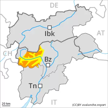
Weakly bonded old snow is to be evaluated with care and prudence. Gliding avalanches require caution.
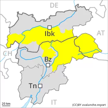
Avalanches can be triggered in the old snowpack and reach quite a large size. Avalanche prone locations are to be found in all aspects above approximately 2400 m. Caution is to be exercised in particular along the border with Italy. Defensive route selection is recommended.
In addition an appreciable danger of gliding avalanches exists, in particular on steep sunny slopes below approximately 2600 m, as well as on steep shady slopes below approximately 2400 m. These can reach dangerously large size. Areas with glide cracks are to be avoided as far as possible.
The somewhat older wind slabs can still be released in some cases on very steep shady slopes above approximately 2600 m. This applies especially adjacent to ridgelines. In some cases avalanches are medium-sized.
Snowpack
dp.4: cold following warm / warm following cold dp.2: gliding snow
Outgoing longwave radiation during the night will be reduced. The snowpack will be wet all the way through below approximately 2200 m. The snowpack will be moist below approximately 2400 m.
Afternoon: Above approximately 1500 m snow will fall over a wide area.
New snow and wind slabs are lying on a weakly bonded old snowpack. This applies above approximately 2400 m in all aspects. The somewhat older wind slabs are lying on soft layers in particular on shady slopes. This applies above approximately 2600 m.
Tendency
Weakly bonded old snow represents the main danger. Numerous small and medium-sized loose snow avalanches are to be expected. Gliding avalanches require caution.
Danger level
treeline
Avalanche Problem
Wind slab
Treeline
Gliding snow
2600m
Persistent weak layer
2400m
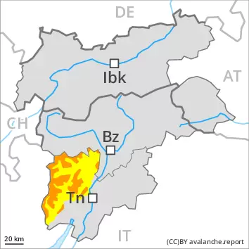
Fresh wind slabs represent the main danger. Gliding snow requires caution. Wet loose snow avalanches are possible in the afternoon.
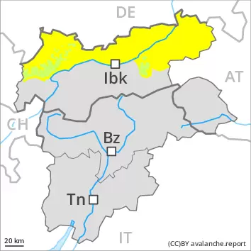
The fresh snow and the sometimes large wind slabs can be released by a single winter sport participant in particular on steep shady slopes above the tree line. This applies especially adjacent to ridgelines. The avalanche danger will increase during the day. The number and size of avalanche prone locations will increase with altitude. The avalanche prone locations are difficult to recognise. Avalanches can in isolated cases reach large size. Weak layers in the old snowpack can still be released in very isolated cases by individual winter sport participants. Avalanche prone locations are to be found in particular on very steep west and east facing slopes above approximately 2400 m. Avalanche prone locations are to be found also on very steep north facing slopes above approximately 2100 m. Avalanches can in isolated cases penetrate deep layers and reach large size.
As a consequence of the new snow loose snow avalanches are possible, even medium-sized ones. In addition an appreciable danger of gliding avalanches exists, especially on grassy slopes below approximately 2600 m, as well as on steep shady slopes below approximately 2400 m. These can reach dangerously large size. Areas with glide cracks are to be avoided.
Snowpack
dp.6: cold, loose snow and wind dp.2: gliding snow
In some regions up to 30 cm of snow, and even more in some localities, has fallen since Saturday above approximately 1500 m. Over a wide area up to 20 cm of snow, and even more in some localities, will fall above approximately 1000 m. Outgoing longwave radiation during the night will be reduced.
As a consequence of new snow and strong wind the wind slabs have increased in size. Fresh and somewhat older wind slabs are lying on soft layers in particular on shady slopes. They are in some cases prone to triggering. This applies above the tree line. Isolated avalanche prone weak layers exist deeper in the snowpack in particular on steep east, north and west facing slopes. In very isolated cases new snow and wind slabs are lying on a weakly bonded old snowpack.
Tendency
Over a wide area 20 to 40 cm of snow, and even more in some localities, will fall until Wednesday. As a consequence of new snow and strong wind the wind slabs will increase in size. Numerous small and medium-sized loose snow avalanches are to be expected. The fresh snow and the sometimes large wind slabs represent the main danger. Gliding avalanches require caution.
Danger level
treeline
Avalanche Problem
Wind slab
Treeline
Gliding snow
2600m
Persistent weak layer
2400m
Fresh wind slabs represent the main danger. Gliding snow requires caution. Wet loose snow avalanches are possible in the afternoon.
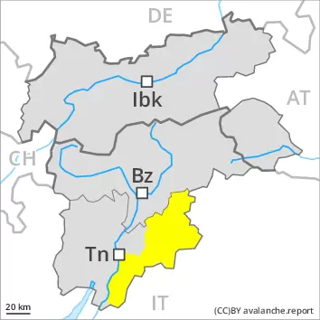
The fresh snow and the sometimes large wind slabs can be released by a single winter sport participant in particular on steep shady slopes above the tree line. This applies especially adjacent to ridgelines. The avalanche danger will increase during the day. The number and size of avalanche prone locations will increase with altitude. The avalanche prone locations are difficult to recognise. Avalanches can in isolated cases reach large size. Weak layers in the old snowpack can still be released in very isolated cases by individual winter sport participants. Avalanche prone locations are to be found in particular on very steep west and east facing slopes above approximately 2400 m. Avalanche prone locations are to be found also on very steep north facing slopes above approximately 2100 m. Avalanches can in isolated cases penetrate deep layers and reach large size.
As a consequence of the new snow loose snow avalanches are possible, even medium-sized ones. In addition an appreciable danger of gliding avalanches exists, especially on grassy slopes below approximately 2600 m, as well as on steep shady slopes below approximately 2400 m. These can reach dangerously large size. Areas with glide cracks are to be avoided.
Snowpack
dp.6: cold, loose snow and wind dp.2: gliding snow
In some regions up to 30 cm of snow, and even more in some localities, has fallen since Saturday above approximately 1500 m. Over a wide area up to 20 cm of snow, and even more in some localities, will fall above approximately 1200 m.
As a consequence of new snow and strong wind the wind slabs have increased in size. Fresh and somewhat older wind slabs are lying on soft layers in particular on shady slopes. They are in some cases prone to triggering. This applies above the tree line. Isolated avalanche prone weak layers exist deeper in the snowpack in particular on steep east, north and west facing slopes. In very isolated cases new snow and wind slabs are lying on a weakly bonded old snowpack.
Tendency
Over a wide area 20 to 40 cm of snow, and even more in some localities, will fall until Wednesday. As a consequence of new snow and strong wind the wind slabs will increase in size. Numerous small and medium-sized loose snow avalanches are to be expected. The fresh snow and the sometimes large wind slabs represent the main danger. Gliding avalanches require caution.
Danger level
2600m
Avalanche Problem
Gliding snow
2600m
Wind slab
2600m
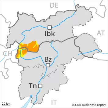
Gliding avalanches are the main danger. Fresh wind slabs at high altitude.
An appreciable danger of gliding avalanches exists, in particular on steep sunny slopes below approximately 2600 m, as well as on steep shady slopes below approximately 2400 m. These can reach dangerously large size. Areas with glide cracks are to be avoided as far as possible.
The fresh wind slabs can be released by a single winter sport participant in isolated cases in particular on very steep shady slopes above approximately 2600 m. This applies especially adjacent to ridgelines. In some cases avalanches are medium-sized.
Avalanches can in very isolated cases be triggered in the old snowpack. Avalanche prone locations are to be found in particular on very steep east, north and west facing slopes above approximately 2400 m.
Snowpack
dp.2: gliding snow dp.6: cold, loose snow and wind
The snowpack will be wet all the way through below approximately 2200 m. The snowpack will be moist below approximately 2400 m.
Afternoon: Above approximately 1500 m snow will fall over a wide area.
Fresh and somewhat older wind slabs are lying on soft layers in particular on shady slopes. This applies above approximately 2600 m. In very isolated cases new snow and wind slabs are lying on a weakly bonded old snowpack.
Tendency
Increase in avalanche danger as a consequence of the new snow. Numerous small and medium-sized loose snow avalanches are to be expected. Gliding avalanches require caution.
Danger level
2600m
Avalanche Problem
Gliding snow
2600m
Wind slab
2600m
Gliding avalanches are the main danger. Fresh wind slabs at high altitude.
An appreciable danger of gliding avalanches exists, in particular on steep sunny slopes below approximately 2600 m, as well as on steep shady slopes below approximately 2400 m. These can reach dangerously large size. Areas with glide cracks are to be avoided as far as possible.
The fresh wind slabs can be released by a single winter sport participant in isolated cases in particular on very steep shady slopes above approximately 2600 m. This applies especially adjacent to ridgelines. In some cases avalanches are medium-sized.
Avalanches can in very isolated cases be triggered in the old snowpack. Avalanche prone locations are to be found in particular on very steep east, north and west facing slopes above approximately 2400 m.
Snowpack
dp.2: gliding snow dp.6: cold, loose snow and wind
Outgoing longwave radiation during the night will be reduced. The snowpack will be wet all the way through below approximately 2200 m. The snowpack will be moist below approximately 2400 m.
Afternoon: Above approximately 1500 m snow will fall over a wide area.
Fresh and somewhat older wind slabs are lying on soft layers in particular on shady slopes. This applies above approximately 2600 m. In very isolated cases new snow and wind slabs are lying on a weakly bonded old snowpack.
Tendency
Increase in avalanche danger as a consequence of the new snow. Numerous small and medium-sized loose snow avalanches are to be expected. Gliding avalanches require caution.
Danger level
2600m
Avalanche Problem
Gliding snow
2600m
Gliding avalanches require caution.
An appreciable danger of gliding avalanches exists, in particular on steep sunny slopes below approximately 2600 m, as well as on steep shady slopes below approximately 2400 m. These can reach dangerously large size. Areas with glide cracks are to be avoided as far as possible.
Snowpack
dp.2: gliding snow
Outgoing longwave radiation during the night will be reduced. The snowpack will be wet all the way through below approximately 2200 m. The snowpack will be moist below approximately 2400 m.
Afternoon: Above approximately 1500 m snow will fall over a wide area.
Tendency
Increase in avalanche danger as a consequence of the new snow. Numerous small and medium-sized loose snow avalanches are to be expected. Gliding avalanches require caution.
Danger level
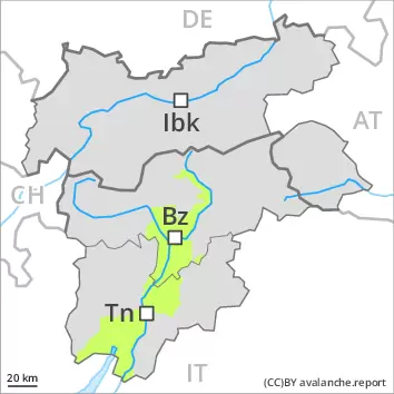
Wind slabs require caution. In addition individual gliding avalanches and moist snow slides are to be expected.
Wind slabs can be released by a single winter sport participant in isolated cases in particular on steep shady slopes at high altitude. Mostly avalanches are only small.
On steep grassy slopes mostly small gliding avalanches and moist snow slides are possible.
Snowpack
dp.6: cold, loose snow and wind dp.10: springtime scenario
Some snow will fall in particular in the north. The wind slabs are in isolated cases prone to triggering.
The snowpack will be moist below approximately 2400 m. At low altitude hardly any snow is lying.