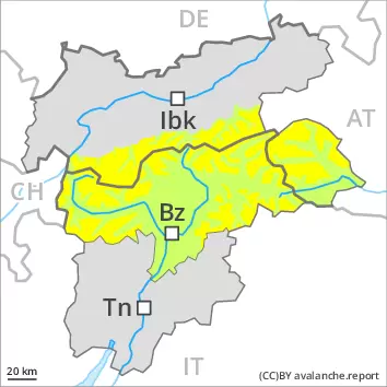
The wind slabs must be evaluated with care and prudence in all aspects at intermediate and high altitudes. The danger of moist snow slides and avalanches will increase during the day.
Below approximately 2500 m small and, in isolated cases, medium-sized moist and wet avalanches are possible. As the day progresses as a consequence of warming during the day and solar radiation there will be a gradual increase in the danger of moist and wet avalanches, in particular on steep sunny slopes above the tree line, as well as on steep east, south and west facing slopes. Individual gliding avalanches can also occur. In the regions with a lot of snow dry slab avalanches are possible, even medium-sized ones. The new snow and wind slabs of the last few days can be released, especially by large additional loads, in all aspects at high altitudes and in high Alpine regions. These can in isolated cases reach medium size. The prevalence of the avalanche prone locations will increase with altitude. Caution is to be exercised in particular adjacent to ridgelines and in gullies and bowls, as well as in places that are protected from the wind.
Snowpack
dp.10: springtime scenario
Outgoing longwave radiation during the night will be quite good. The solar radiation will give rise as the day progresses to gradual moistening of the snowpack in particular on steep sunny slopes at intermediate altitudes. As a consequence of the occasionally strong wind, the snow drift accumulations have increased in size during the last few days. The new snow and wind slabs of the last few days are lying on soft layers above approximately 2200 m. The weather conditions gave rise to gradual settling of the snowpack. In all regions below the tree line a little snow is lying.
Tendency
The weather conditions will facilitate a gradual strengthening of the snowpack. Gradual decrease in danger of dry avalanches. More gliding avalanches and moist snow slides are possible, in particular medium-sized ones.
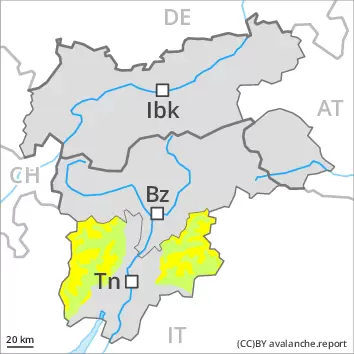
AM Danger level
2200m
Avalanche Problem
Wet snow
2200m
Wind slab
Treeline
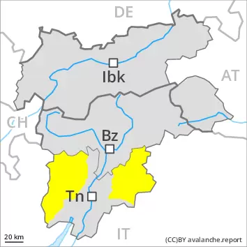
PM Danger level
2200m
Avalanche Problem
Wet snow
2200m
Wind slab
Treeline
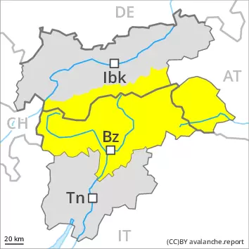
The danger of moist avalanches will increase during the day. The fresh and older wind slabs must be evaluated with care and prudence.
As a consequence of warming moist and wet avalanches are possible as the day progresses, but they can reach medium size in some cases, in particular on steep sunny slopes, as well as at the base of rock walls in all altitude zones. Individual gliding avalanches can also occur. The new snow and wind slabs of the weekend are to be evaluated with care and prudence in all aspects at high altitudes and in high Alpine regions. Avalanches can be triggered in near-surface layers and reach medium size in all aspects. Caution is to be exercised in particular adjacent to ridgelines and in gullies and bowls, as well as in places that are protected from the wind.
Snowpack
dp.10: springtime scenario
Outgoing longwave radiation during the night will be quite good. The solar radiation will give rise as the day progresses to gradual moistening of the snowpack in particular on steep sunny slopes at intermediate altitudes. At low and intermediate altitudes a little snow is lying.
Tendency
The weather conditions will facilitate a gradual strengthening of the snowpack. Gradual decrease in danger of dry avalanches. More gliding avalanches and moist snow slides are possible, even medium-sized ones.
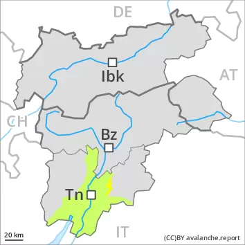
AM Danger level
2600m
Avalanche Problem
Wind slab
2600m
Gliding snow
2600m
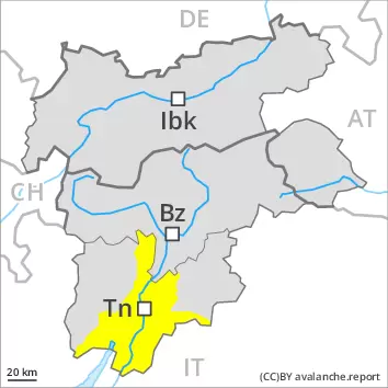
PM Danger level
3000m
Avalanche Problem
Wet snow
3000m
Gliding snow
2600m
Wind slab
2600m
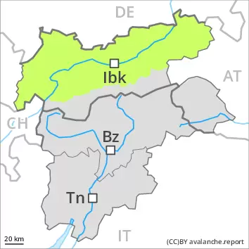
Wind slabs are to be evaluated with care and prudence in particular on very steep shady slopes at elevated altitudes. As the day progresses the likelihood of moist and wet avalanches being released will increase in particular on very steep sunny slopes.
The somewhat older wind slabs can still be released in some cases in particular on very steep shady slopes above approximately 2600 m. Avalanches can reach medium size. The prevalence of the avalanche prone locations will increase with altitude. Caution is to be exercised in particular adjacent to ridgelines and in gullies and bowls. Avalanches can in very isolated cases be triggered in the old snowpack and reach quite a large size. Avalanche prone locations are to be found in particular on steep shady slopes above approximately 2400 m.
During the day: As the day progresses as a consequence of warming during the day and solar radiation there will be a gradual increase in the danger of moist and wet avalanches, in particular on very steep sunny slopes at high altitudes and in high Alpine regions. From origins in starting zones where no previous releases have taken place more gliding avalanches are possible, in particular medium-sized ones. This applies in particular on steep sunny slopes below approximately 2600 m, as well as on steep shady slopes below approximately 2200 m. Caution is to be exercised in areas with glide cracks.
Snowpack
dp.2: gliding snow dp.10: springtime scenario
The fresh and somewhat older wind slabs are lying on soft layers on wind-protected shady slopes above approximately 2600 m. Faceted weak layers exist in the centre of the old snowpack in particular on west, north and east facing slopes. This applies above approximately 2400 m.
Early morning: Outgoing longwave radiation during the night will be reduced in some case. The snowpack is moist and its surface has a melt-freeze crust that is barely capable of bearing a load, especially on steep sunny slopes below approximately 2600 m, as well as on shady slopes below approximately 2200 m. During the day: Sunshine and high temperatures will give rise to a loss of strength within the snowpack, especially on sunny slopes, and on shady slopes at intermediate altitudes. Evening: Some snow will fall in some localities.
Tendency
Increase in danger of moist and wet avalanches. Further decrease in danger of dry avalanches.
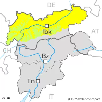
From origins in starting zones where no previous releases have taken place more gliding avalanches are possible, in particular medium-sized ones. This applies in particular on steep sunny slopes below approximately 2600 m, as well as on steep shady slopes below approximately 2200 m. Caution is to be exercised in areas with glide cracks. As a consequence of warming during the day and solar radiation more frequent loose snow avalanches are to be expected, but they will be mostly small.
The somewhat older wind slabs can be released by a single winter sport participant in some cases in particular on extremely steep shady slopes at elevated altitudes. Caution is to be exercised in particular adjacent to ridgelines and in gullies and bowls.
Snowpack
dp.6: cold, loose snow and wind dp.2: gliding snow
The fresh and somewhat older wind slabs are lying on soft layers on wind-protected shady slopes above approximately 2600 m.
Early morning: Outgoing longwave radiation during the night will be reduced in some case. The snowpack is moist and its surface has a melt-freeze crust that is barely capable of bearing a load, especially on steep sunny slopes below approximately 2600 m, as well as on shady slopes below approximately 2200 m. During the day: Sunshine and high temperatures will give rise to a loss of strength within the snowpack, especially on sunny slopes, and on shady slopes at intermediate altitudes. Evening: Some snow will fall in some localities.
Tendency
Increase in danger of moist and wet avalanches. Further decrease in danger of dry avalanches.