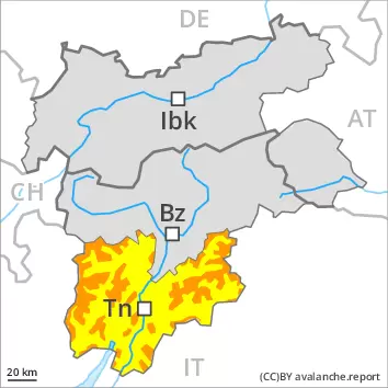
The large quantity of fresh snow and in particular the wind slabs formed during the snowfall can be released by a single winter sport participant in all aspects above the tree line. Remotely triggered avalanches are possible, in particular in gullies and bowls, and behind abrupt changes in the terrain. In all aspects more frequent small and medium-sized loose snow avalanches are to be expected as a consequence of warming during the day, in particular on steep grassy slopes below approximately 2200 m, as well as at the base of rock walls. Areas with glide cracks are to be avoided as far as possible.
Snowpack
dp.6: cold, loose snow and wind
Over a wide area over a wide area 30 to 50 cm of snow, and even more in some localities, fell in the last few days above approximately 1500 m. The wind was strong to storm force at times. In places that are protected from the wind sometimes large wind slabs formed. These are poorly bonded with the old snowpack in all aspects above the tree line. 5 to 15 cm of snow, and even more in some localities, will fall on Friday above approximately 1800 m. The wind slabs will be covered with new snow in some cases and therefore difficult to recognise.
Tendency
In some regions 20 to 30 cm of snow will fall on Saturday above approximately 2000 m. New snow and wind slabs require caution. The avalanche danger will persist.
Danger level
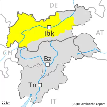
2200m
Avalanche Problem
Wind slab
2200m
Gliding snow
2600m
A precarious avalanche situation will persist in some cases. Fresh wind slabs are to be evaluated critically.
As a consequence of a strong to storm force wind, further wind slabs will form. These can be released even by a single winter sport participant in particular on very steep west, north and southeast facing slopes. Caution is to be exercised in particular in gullies and bowls, and behind abrupt changes in the terrain above approximately 2200 m. The prevalence of avalanche prone locations and likelihood of triggering will increase with altitude. Isolated natural avalanches are possible. This applies in particular on very steep shady slopes adjacent to ridgelines especially in high Alpine regions. Mostly avalanches are medium-sized.
On steep grassy slopes more medium-sized gliding avalanches are possible. This applies especially on steep sunny slopes below approximately 2600 m, including on steep shady slopes below approximately 2200 m. Areas with glide cracks are to be avoided.
As a consequence of warming during the day more frequent moist loose snow avalanches are to be expected. This applies on extremely steep slopes in all aspects, in the event of prolonged bright spells especially.
Backcountry touring calls for extensive experience and a certain restraint.
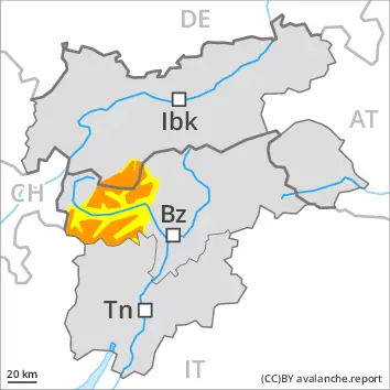
Snowpack
dp.6: cold, loose snow and wind dp.2: gliding snow
25 to 40 cm of snow, and even more in some localities, has fallen since Wednesday. Some snow will fall on Friday in some localities. The wind will be strong to storm force. Fresh and somewhat older wind slabs are lying on soft layers in particular on west to north to southeast facing aspects at elevated altitudes. The high temperatures as the day progresses will give rise to increasing moistening of the snowpack.
Tendency
From midday as a consequence of new snow and strong wind there will be an increase in the avalanche danger within the current danger level. 15 to 30 cm of snow will fall. Fresh wind slabs represent the main danger. Gliding snow requires caution.
Danger level
2200m
Avalanche Problem
Wind slab
2200m
Gliding snow
2600m
Fresh wind slabs are to be evaluated critically.
As a consequence of a strong to storm force wind, further wind slabs will form. These can be released even by a single winter sport participant in particular on very steep northwest, north and east facing slopes. Caution is to be exercised in particular in gullies and bowls, and behind abrupt changes in the terrain above approximately 2200 m. The prevalence of avalanche prone locations and likelihood of triggering will increase with altitude.
On steep grassy slopes more medium-sized gliding avalanches are possible. This applies especially on steep sunny slopes below approximately 2600 m, including on steep shady slopes below approximately 2200 m. Areas with glide cracks are to be avoided.
As a consequence of warming during the day more frequent moist loose snow avalanches are to be expected. This applies on extremely steep slopes in all aspects, in the event of prolonged bright spells especially.
Backcountry touring calls for experience and a certain restraint.
Snowpack
dp.6: cold, loose snow and wind dp.2: gliding snow
15 to 30 cm of snow, and even more in some localities, has fallen since Wednesday. Some snow will fall on Friday in some localities. The wind will be strong to storm force. Fresh and somewhat older wind slabs are lying on soft layers in particular on northwest to north to east facing aspects at elevated altitudes. The high temperatures as the day progresses will give rise to increasing moistening of the snowpack.
Tendency
From midday as a consequence of new snow and strong wind there will be only a slight increase in the avalanche danger. Fresh wind slabs represent the main danger. Gliding snow requires caution.
Danger level
Avalanche Problem
Gliding snow
Gliding snow requires caution.
On steep grassy slopes medium-sized gliding avalanches are possible. This applies especially on steep sunny slopes below approximately 2600 m, including on steep shady slopes below approximately 2200 m. Avalanches can reach medium size. Areas with glide cracks are to be avoided.
As the day progresses more frequent moist loose snow slides are to be expected.
The fresh wind slabs are mostly small and unlikely to be released now. Individual avalanche prone locations are to be found on very steep shady slopes above approximately 2400 m. Restraint should be exercised because avalanches can sweep people along and give rise to falls.
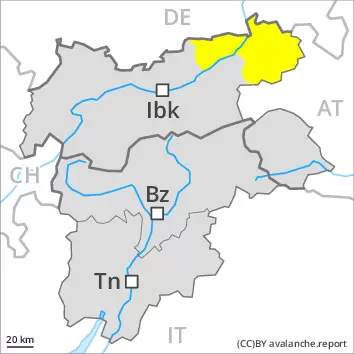
Snowpack
dp.2: gliding snow
5 to 15 cm of snow has fallen since Wednesday. The wind will be strong to storm force. Fresh wind slabs are lying on soft layers on shady slopes at elevated altitudes. The high temperatures as the day progresses will give rise to increasing moistening of the snowpack.
Tendency
The weather conditions will give rise to moistening of the snowpack.
Danger level
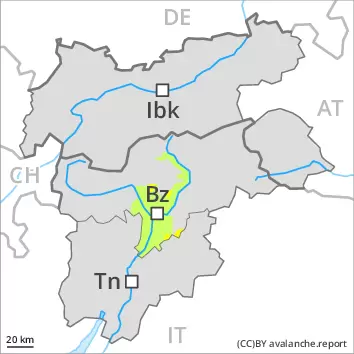
2400m
Avalanche Problem
Wind slab
2400m
Gliding snow
2600m
Wind slabs and gliding snow require caution.
As a consequence of a strong to storm force wind, further wind slabs will form. These can be released even by a single winter sport participant in particular on very steep shady slopes. Caution is to be exercised in particular in gullies and bowls, and behind abrupt changes in the terrain above approximately 2400 m. The prevalence of avalanche prone locations and likelihood of triggering will increase with altitude.
On steep grassy slopes more medium-sized and, in isolated cases, large gliding avalanches are possible. This applies especially on steep sunny slopes below approximately 2600 m, including on steep shady slopes below approximately 2200 m. Areas with glide cracks are to be avoided.
As a consequence of warming during the day more frequent moist loose snow avalanches are to be expected. This applies on extremely steep slopes in all aspects, in the event of prolonged bright spells especially.
Backcountry touring calls for experience and a certain restraint.
Snowpack
dp.6: cold, loose snow and wind dp.2: gliding snow
5 to 20 cm of snow, and even more in some localities, has fallen since Wednesday. The wind will be strong to storm force. Fresh and somewhat older wind slabs are lying on soft layers in particular on shady slopes at elevated altitudes. The high temperatures as the day progresses will give rise to increasing moistening of the snowpack.
Tendency
Fresh wind slabs represent the main danger. Gliding snow requires caution.
Danger level
2200m
Avalanche Problem
Wind slab
2200m
Gliding snow
2600m
Fresh wind slabs are to be evaluated critically.
As a consequence of a strong to storm force wind, further wind slabs will form. These can be released even by a single winter sport participant in particular on very steep northwest, north and east facing slopes. Caution is to be exercised in particular in gullies and bowls, and behind abrupt changes in the terrain above approximately 2200 m. The prevalence of avalanche prone locations and likelihood of triggering will increase with altitude.
On steep grassy slopes gliding avalanches are possible. This applies especially on steep sunny slopes at elevated altitudes, including on steep shady slopes below approximately 2200 m. Areas with glide cracks are to be avoided.
As a consequence of warming during the day more frequent moist loose snow avalanches are to be expected. This applies on extremely steep slopes in all aspects, in the event of prolonged bright spells especially.
Backcountry touring calls for experience and a certain restraint.
Snowpack
dp.6: cold, loose snow and wind dp.2: gliding snow
15 to 30 cm of snow, and even more in some localities, has fallen since Wednesday. Some snow will fall on Friday in some localities. The wind will be strong to storm force. Fresh and somewhat older wind slabs are lying on soft layers in particular on northwest to north to east facing aspects at elevated altitudes. The high temperatures as the day progresses will give rise to increasing moistening of the snowpack.
Tendency
From midday as a consequence of new snow and strong wind there will be only a slight increase in the avalanche danger. Fresh wind slabs represent the main danger. Gliding snow requires caution.