Significant warming: The danger of wet avalanches will already increase in the late morning.
As a consequence of warming and solar radiation, the natural activity of wet avalanches will rapidly increase. This applies on steep east, south and west facing slopes, this also applies on shady slopes below approximately 2400 m. The wet avalanches can release the saturated snowpack and reach medium size. In steep gullies avalanches can in isolated cases reach areas without any snow cover.
On steep grassy slopes more frequent medium-sized and, in isolated cases, large gliding avalanches are possible below approximately 2600 m. Areas with glide cracks are to be avoided.
Backcountry tours and ascents to alpine cabins should be started and concluded very early.
Snowpack
dp.10: springtime scenario dp.2: gliding snow
The weather will be exceptionally warm. The surface of the snowpack is hardly frozen at all and will already soften in the late morning. Sunshine and high temperatures will give rise from late morning to extreme and thorough wetting of the snowpack. These conditions will cause a rapid weakening of the snowpack. In areas with a thinner snowpack the saturation and consequently the loss of strength happens more rapidly Hardly any snow is lying at low and intermediate altitudes.
Tendency
The weather will be exceptionally warm. The summery weather conditions will give rise to increasing and thorough wetting of the snowpack at elevated altitudes. The danger of wet and gliding avalanches will persist.
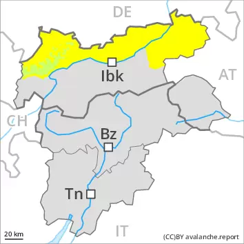
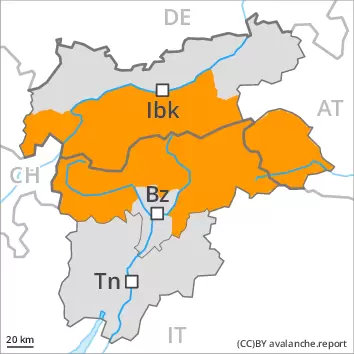
AM Danger level
2600m
Avalanche Problem
Wet snow
2600m
Gliding snow
2600m
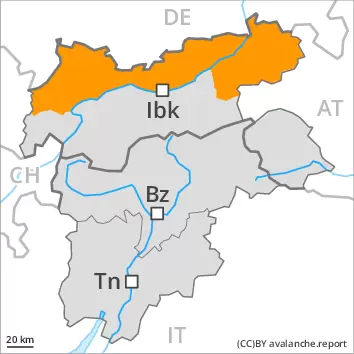
PM Danger level
Avalanche Problem
Wet snow
Gliding snow
2600m
Significant warming: The danger of wet avalanches will already increase in the late morning.
As a consequence of warming and solar radiation, the natural activity of wet avalanches will rapidly increase. This applies on steep east and west facing slopes below approximately 2800 m, as well as on steep south facing slopes in all altitude zones, this also applies on shady slopes below approximately 2400 m. The wet avalanches can release the saturated snowpack and reach large size in some cases. In steep gullies avalanches can in some cases reach areas without any snow cover. The danger of natural wet avalanches is within the upper range of danger level 3 (considerable).
On steep grassy slopes more frequent medium-sized and, in isolated cases, large gliding avalanches are possible below approximately 2600 m. Areas with glide cracks are to be avoided.
Backcountry tours and ascents to alpine cabins should be started and concluded very early.
Snowpack
dp.10: springtime scenario dp.2: gliding snow
The weather will be exceptionally warm. The surface of the snowpack is hardly frozen at all and will already soften in the late morning. Sunshine and high temperatures will give rise from late morning to extreme and thorough wetting of the snowpack. These conditions will cause a rapid weakening of the snowpack. In areas with a thinner snowpack the saturation and consequently the loss of strength happens more rapidly Hardly any snow is lying at low and intermediate altitudes.
Tendency
The weather will be exceptionally warm. The summery weather conditions will give rise to increasing and thorough wetting of the snowpack at elevated altitudes. The danger of wet and gliding avalanches will persist.
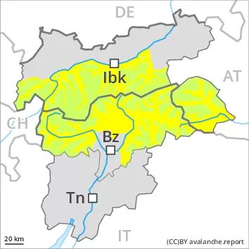
AM Danger level
2800m
Avalanche Problem
Wet snow
2800m
Gliding snow
2600m
PM Danger level
2800m
Avalanche Problem
Wet snow
2800m
Gliding snow
2600m
Wet snow
2800m
Wet and gliding avalanches are the main danger. Wet and gliding snow require caution.
As a consequence of warming during the day and the solar radiation, the likelihood of gliding avalanches and wet snow slides being released will increase quickly in all aspects. In isolated cases, wet avalanches can reach intermediate altitudes in steep gullies. On steep grassy slopes medium-sized to large gliding avalanches are possible. This applies on steep sunny slopes in all altitude zones, as well as on steep shady slopes below approximately 2600 m. Areas with glide cracks are to be avoided.
Snowpack
dp.10: springtime scenario dp.2: gliding snow
Outgoing longwave radiation during the night was reduced. The surface of the snowpack is not frozen and will already be soft in the early morning. Sunshine and high temperatures will give rise as the day progresses to extreme and thorough wetting of the snowpack. This applies on sunny slopes in all altitude zones, as well as on shady slopes also at intermediate and high altitudes.
Tendency
Until Monday the weather will be exceptionally warm. The danger of wet and gliding avalanches will persist.
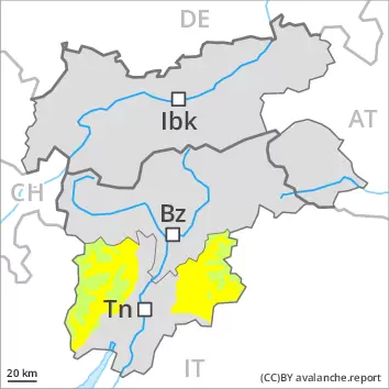
AM Danger level
2000m
Avalanche Problem
Gliding snow
2000m
Wet snow
Treeline
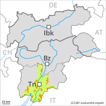
PM Danger level
treeline
Avalanche Problem
Wet snow
Treeline
Gliding snow
2000m
Gliding avalanches and moist snow slides are the main danger.
On steep grassy slopes medium-sized gliding avalanches are possible. As a consequence of warming during the day and the solar radiation, the likelihood of gliding avalanches and wet snow slides being released will increase quickly in all aspects, not only on sunny slopes, including on steep shady slopes at intermediate and high altitudes. In isolated cases, wet avalanches can reach intermediate altitudes in steep gullies. Areas with glide cracks are to be avoided.
Snowpack
dp.10: springtime scenario dp.2: gliding snow
Outgoing longwave radiation during the night will be reduced in some case. The surface of the snowpack will freeze very little and will already be soft in the early morning. This applies on sunny slopes in all altitude zones, as well as on shady slopes also at intermediate and high altitudes.
Tendency
Until Monday the weather will be exceptionally warm. The danger of wet and gliding avalanches will persist.
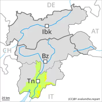
Danger level
2000m
Avalanche Problem
Wet snow
2000m
Significant warming: The danger of wet avalanches will already increase in the late morning.
As a consequence of warming and solar radiation, the natural activity of wet avalanches will rapidly increase. This applies in all aspects. The wet avalanches can release the saturated snowpack and reach medium size in isolated cases. On steep grassy slopes small and, in isolated cases, medium-sized gliding avalanches are possible.
Snowpack
dp.10: springtime scenario
The weather will be exceptionally warm. The surface of the snowpack is hardly frozen at all and will already soften in the late morning. These conditions will cause a rapid weakening of the snowpack. Hardly any snow is lying at low and intermediate altitudes.
Tendency
The weather will be exceptionally warm. The danger of wet and gliding avalanches will persist.