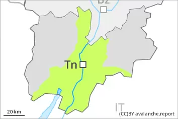
New snow is to be evaluated with care and prudence. As a consequence of new snow a moderate danger of gliding avalanches and snow slides will be encountered in some localities.
In all regions at elevated altitudes snow depths vary greatly, depending on the infuence of the wind. Adjacent to ridgelines and in gullies and bowls sometimes easily released wind slabs formed. At low altitude a low danger of gliding avalanches and moist snow slides will be encountered in some localities. Remotely triggered and natural avalanches are possible in isolated cases.
Snowpack
dp.6: cold, loose snow and wind
The Avalanche Warning Service currently has only a small amount of information that has been collected in the field, so that the avalanche danger should be investigated especially thoroughly in the relevant locality. Precarious weak layers exist in the snowpack at transitions from a shallow to a deep snowpack, when entering gullies and bowls for example. The new snow and wind slabs of the last few days will be deposited on the unfavourable surface of an old snowpack in particular on steep shady slopes. The barely recognisable wind slabs of the last few days are to be avoided as far as possible in particular on steep shady slopes at elevated altitudes. These have formed especially adjacent to ridgelines and in gullies and bowls and generally at elevated altitudes.
Tendency
The danger of gliding avalanches and moist snow slides will increase during the day.
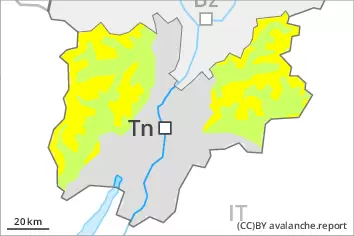
Danger level
Avalanche Problem
Persistent weak layer
Wet snow
New snow and wind slabs require caution. At elevated altitudes a considerable danger will prevail. At low and intermediate altitudes thus far only a little snow is lying.
Between approximately 1300 and 2000 m there are 10 to 20 cm of snow. Here from a snow sport perspective, in most cases insufficient snow is lying. Above approximately 2000 m there are 30 to 50 cm of snow, and even as much as 80 cm in some localities. The wind was strong at times in some localities. In particular in gullies and bowls and behind abrupt changes in the terrain as well as at high altitudes and in high Alpine regions precarious wind slabs formed, especially above approximately 2000 m. The snowpack will be subject to considerable local variations above approximately 2200 m. At low and intermediate altitudes a low danger will prevail. At high altitudes and in high Alpine regions the avalanche prone locations are more prevalent and larger. Even single backcountry tourers can release avalanches in some places, including medium-sized ones. Remotely triggered avalanches are possible in isolated cases.
Snowpack
The Avalanche Warning Service currently has only a small amount of information that has been collected in the field. Faceted weak layers exist in the snowpack in particular on steep shady slopes. The new snow and wind slabs of the last few days are lying on the unfavourable surface of an old snowpack in particular on northwest to north to east facing aspects above approximately 2200 m. The mostly small wind slabs are to be avoided as far as possible in particular on steep shady slopes at elevated altitudes. These are to be found especially adjacent to ridgelines and in gullies and bowls and generally at high altitudes.