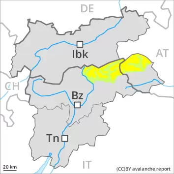
Over a wide area warming above the tree line. Old wind slabs are to be evaluated critically.
As a consequence of new snow and a moderate wind from southerly directions, sometimes avalanche prone wind slabs formed in the last few days adjacent to ridgelines and in gullies and bowls as well as at high altitude. Avalanches can be released by a single winter sport participant. On wind-loaded slopes medium-sized avalanches are possible. Natural avalanches and moist loose snow avalanches are still possible in particular in the middle of the day. In addition on south and southwest facing slopes, still more individual small and medium-sized gliding avalanches are possible. The avalanche prone locations are to be found in all aspects above approximately 1800 m. Caution is to be exercised in gullies and bowls, and behind abrupt changes in the terrain, as well as adjacent to ridgelines.
Snowpack
Over a wide area 20 to 30 cm of snow, and even more in some localities, has fallen since Thursday above approximately 1500 m. In the last two days sometimes avalanche prone wind slabs formed in some localities. Towards its base, the snowpack is faceted.
Tendency
The avalanche danger will decrease gradually.
AM Danger level
2000m
Avalanche Problem
Persistent weak layer
2000m
PM Danger level
2000m
Avalanche Problem
Persistent weak layer
2000m
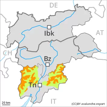
Gliding snow
2200m
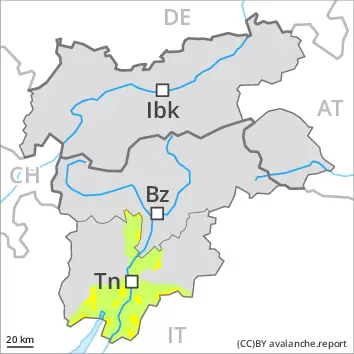
Weakly bonded old snow is to be evaluated with care and prudence. Slight increase in danger of gliding avalanches as a consequence of warming during the day.
Weak layers in the old snowpack can be released in some places by individual winter sport participants. The avalanche prone locations are to be found in particular on very steep west, north and east facing slopes above approximately 2000 m and on very steep south facing slopes above approximately 3000 m. The wind slabs of the last few days can be released by a single winter sport participant in some cases in particular on near-ridge shady slopes at elevated altitudes. Individual medium-sized avalanches are possible. Meticulous route selection is advisable. As a consequence of warming individual gliding avalanches and moist snow slides are possible as the day progresses, but they will be mostly small. This applies in particular on very steep sunny slopes, as well as on cut and grassy slopes at low and intermediate altitudes.
Snowpack
dp.1: deep persistent weak layer dp.2: gliding snow
The new snow and wind slabs of the last few days are lying on top of a weakly bonded old snowpack, especially on very steep west, north and east facing slopes above approximately 2000 m. The weather conditions as the day progresses will give rise to slight moistening of the snowpack at low and intermediate altitudes. This applies on steep sunny slopes. Only a small amount of snow is lying for the time of year.
Tendency
Weakly bonded old snow represents the main danger. Small gliding avalanches and snow slides are possible as a consequence of warming.
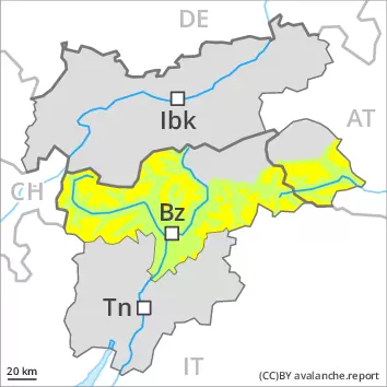
Danger level
2000m
Avalanche Problem
Persistent weak layer
2000m
Weak layers in the old snowpack can be released in isolated cases on shady slopes.
Weak layers in the old snowpack can be released in isolated cases by individual winter sport participants. The avalanche prone locations are to be found in particular on very steep shady slopes above approximately 2000 m, especially at the base of rock walls and behind abrupt changes in the terrain, as well as on wind-loaded slopes. Here medium-sized avalanches are possible. In addition the small wind slabs are prone to triggering in very isolated cases still. Avalanche prone locations are to be found in particular on north and east facing slopes at elevated altitudes. Wind slabs are to be avoided in particular in terrain where there is a danger of falling.
As a consequence of warming small moist loose snow avalanches are to be expected. This applies on extremely steep sunny slopes, as well as on cut and grassy slopes especially at low and intermediate altitudes. On steep grassy slopes more frequent gliding avalanches are possible, but they will be mostly small.
Snowpack
dp.1: deep persistent weak layer dp.2: gliding snow
Avalanche prone weak layers exist in the old snowpack, especially on very steep shady slopes above approximately 2000 m, as well as on sunny slopes in high Alpine regions. As a consequence of new snow and a moderate wind, small wind slabs formed adjacent to ridgelines and in pass areas. They are in individual cases still prone to triggering on very steep shady slopes at elevated altitudes. As a consequence of rising temperatures the snow drift accumulations will stabilise.
Sunshine and high temperatures will give rise as the day progresses to gradual moistening of the snowpack in particular on sunny slopes at low and intermediate altitudes.
Tendency
Tuesday: The old snowpack remains prone to triggering in some places.
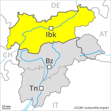
Danger level
2000m
Avalanche Problem
Persistent weak layer
2000m
Weakly bonded old snow represents the main danger.
Weak layers in the old snowpack can be released in some places by individual winter sport participants. The avalanche prone locations are to be found in particular on steep west, north and east facing slopes above approximately 2000 m, especially in shady places that are protected from the wind. Avalanches can reach medium size. Isolated whumpfing sounds can indicate the danger. Meticulous route selection is recommended. In addition the mostly small wind slabs are prone to triggering in isolated cases still. Caution is to be exercised adjacent to ridgelines and in pass areas on very steep north and east facing slopes at high altitudes and in high Alpine regions. At elevated altitudes the avalanche prone locations are a little more prevalent.
As a consequence of warming small moist loose snow avalanches are to be expected. This applies on extremely steep sunny slopes, as well as on cut and grassy slopes especially at low and intermediate altitudes. On steep grassy slopes more frequent gliding avalanches are possible, but they will be mostly small.
Snowpack
dp.1: deep persistent weak layer dp.2: gliding snow
Avalanche prone weak layers exist in the old snowpack, especially on steep shady slopes above approximately 2000 m, as well as on steep sunny slopes in high Alpine regions. Released avalanches and field observations confirm the unfavourable bonding of the snowpack. As a consequence of new snow and a moderate wind, mostly small wind slabs formed adjacent to ridgelines and in pass areas. They are in some cases still prone to triggering especially on very steep shady slopes at elevated altitudes. As a consequence of rising temperatures the snow drift accumulations will stabilise during the next few days.
Sunshine and high temperatures will give rise as the day progresses to gradual moistening of the snowpack in particular on sunny slopes at low and intermediate altitudes.
Tendency
Tuesday: The old snowpack remains prone to triggering on shady slopes. Even single winter sport participants can release avalanches in some places, including dangerously large ones.
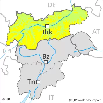
Danger level
treeline
Avalanche Problem
Wind slab
Treeline
Over a wide area warming above the tree line. Old wind slabs are to be evaluated critically.
As a consequence of new snow and a moderate wind from southerly directions, sometimes avalanche prone wind slabs formed in the last few days adjacent to ridgelines and in gullies and bowls as well as at high altitude. On wind-loaded slopes medium-sized avalanches are possible. The avalanche prone locations are to be found in all aspects above approximately 1800 m. Caution is to be exercised in gullies and bowls, and behind abrupt changes in the terrain, as well as adjacent to ridgelines. In addition from midday in particular on south and southwest facing slopes, still more individual small and medium-sized gliding avalanches are possible.
Snowpack
dp.6: cold, loose snow and wind
Over a wide area 20 to 30 cm of snow, and even more in some localities, has fallen since Thursday above approximately 1500 m. In the last two days sometimes avalanche prone wind slabs formed in some localities. Towards its base, the snowpack is faceted.