Weakly bonded old snow represents the main danger.
Weak layers in the old snowpack can be released in some places by individual winter sport participants. The avalanche prone locations are to be found in particular on steep west, north and east facing slopes above approximately 2000 m. Caution is to be exercised in particular adjacent to ridgelines, as well as in gullies and bowls, and behind abrupt changes in the terrain. Whumpfing sounds and the formation of shooting cracks when stepping on the snowpack indicate the danger. Avalanches can reach medium size. The mostly small wind slabs of the last few days are in individual cases still prone to triggering, especially on shady slopes at high altitudes and in high Alpine regions, as well as adjacent to ridgelines. Meticulous route selection is recommended. As a consequence of warming during the day and solar radiation gliding avalanches and moist snow slides are possible, in particular on sunny slopes, as well as on cut and grassy slopes especially at intermediate altitudes.
Snowpack
dp.1: deep persistent weak layer dp.2: gliding snow
Towards its base, the snowpack is faceted and weak, especially on steep west, north and east facing slopes above approximately 2000 m, as well as on steep sunny slopes in high Alpine regions. Released avalanches and field observations confirm the unfavourable bonding of the snowpack. In some cases the wind slabs have bonded still only poorly together. As a consequence of mild temperatures the snow drift accumulations will stabilise on Tuesday. Sunshine and high temperatures will give rise to gradual softening of the snowpack in some cases on sunny slopes in particular at intermediate altitudes.
Tendency
The old snowpack remains prone to triggering on shady slopes. As a consequence of the moderate to strong wind, fresh snow drift accumulations will form on Wednesday.
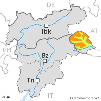
Danger level
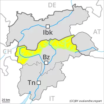
2000m
Avalanche Problem
Persistent weak layer
2000m
Weakly bonded old snow represents the main danger.
Weak layers in the old snowpack can still be released in some places by individual winter sport participants. The avalanche prone locations are to be found in particular on very steep west, north and east facing slopes above approximately 2000 m and on very steep south facing slopes above approximately 3000 m. The mostly small wind slabs can be released by a single winter sport participant in some cases in particular on near-ridge shady slopes at elevated altitudes. Avalanches can reach medium size. Meticulous route selection is advisable. As a consequence of warming individual gliding avalanches and moist snow slides are possible as the day progresses, but they will be mostly small. This applies in particular on very steep sunny slopes, as well as on cut and grassy slopes at intermediate altitudes.
Snowpack
dp.1: deep persistent weak layer dp.2: gliding snow
Towards its base, the snowpack is faceted and weak, especially on steep west, north and east facing slopes above approximately 2000 m, as well as on steep sunny slopes in high Alpine regions. Released avalanches and field observations confirm the unfavourable bonding of the snowpack. On Tuesday mostly small wind slabs will form in the regions exposed to the foehn wind. This applies adjacent to ridgelines and in pass areas. Sunshine and high temperatures will give rise to gradual softening of the snowpack at low and intermediate altitudes. This applies on sunny slopes, and in the regions exposed to the foehn wind. Only a small amount of snow is lying for the time of year.
Tendency
The old snowpack remains prone to triggering. As a consequence of snowfall above approximately 1600 m and the moderate to strong wind, fresh snow drift accumulations will form on Wednesday.
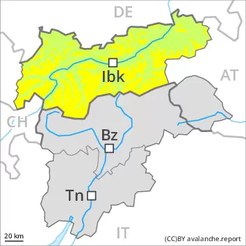
Danger level
2200m
Avalanche Problem
Persistent weak layer
2200m
The old snowpack remains prone to triggering.
Weak layers in the old snowpack can be released in isolated cases by individual winter sport participants. The avalanche prone locations are to be found in particular on very steep shady slopes above approximately 2200 m. Caution is to be exercised in shady places that are protected from the wind at elevated altitudes. Avalanches can reach medium size. In addition the small wind slabs are prone to triggering in very isolated cases still. They are to be avoided as far as possible.
As a consequence of warming gliding avalanches and moist snow slides are to be expected, in particular on sunny slopes.
Snowpack
dp.1: deep persistent weak layer
Avalanche prone weak layers exist in the old snowpack, especially on very steep shady slopes above approximately 2200 m, as well as on sunny slopes in high Alpine regions. In some cases the wind slabs have bonded still only poorly with each other and the old snowpack. They are in individual cases still prone to triggering especially on very steep shady slopes at elevated altitudes. As a consequence of rising temperatures the snow drift accumulations will stabilise on Tuesday.
Sunshine and high temperatures will give rise as the day progresses to gradual moistening of the snowpack on sunny slopes in particular at intermediate altitudes.
Tendency
The old snowpack remains prone to triggering on shady slopes. As a consequence of the moderate to strong wind, fresh snow drift accumulations will form on Wednesday.
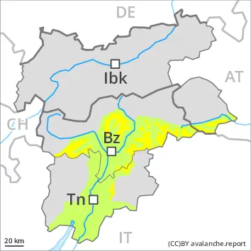
Danger level
2200m
Avalanche Problem
Persistent weak layer
2200m
Wet snow
2200m
The old snowpack remains prone to triggering.
Weak layers in the old snowpack can be released in isolated cases by individual winter sport participants. The avalanche prone locations are to be found in particular on very steep shady slopes above approximately 2200 m. Caution is to be exercised in shady places that are protected from the wind at elevated altitudes. Avalanches can reach medium size. In addition the small wind slabs are prone to triggering in very isolated cases still. They are to be avoided as far as possible.
As a consequence of warming gliding avalanches and moist snow slides are to be expected, in particular on steep sunny slopes, as well as on cut and grassy slopes at low and intermediate altitudes.
Snowpack
dp.1: deep persistent weak layer dp.2: gliding snow
Avalanche prone weak layers exist in the old snowpack, especially on very steep shady slopes above approximately 2200 m, as well as on sunny slopes in high Alpine regions. In some cases the wind slabs have bonded still only poorly with each other and the old snowpack. They are in individual cases still prone to triggering especially on very steep shady slopes at elevated altitudes. As a consequence of rising temperatures the snow drift accumulations will stabilise on Tuesday.
Sunshine and high temperatures will give rise as the day progresses to gradual moistening of the snowpack in particular on sunny slopes at intermediate altitudes.
Tendency
The old snowpack remains prone to triggering on shady slopes. As a consequence of the moderate to strong wind, fresh snow drift accumulations will form on Wednesday.
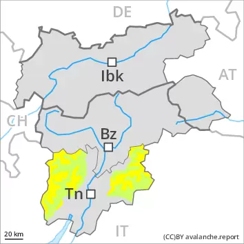
Danger level
2000m
Avalanche Problem
Persistent weak layer
2000m
Weakly bonded old snow represents the main danger.
Weak layers in the old snowpack can be released in some places by individual winter sport participants. The avalanche prone locations are to be found in particular on steep west, north and east facing slopes above approximately 2000 m. Caution is to be exercised in particular in shady places that are protected from the wind. Whumpfing sounds and the formation of shooting cracks when stepping on the snowpack indicate the danger. Avalanches can reach medium size. The mostly small wind slabs of the last few days are in individual cases still prone to triggering, especially adjacent to ridgelines and in pass areas, as well as on very steep north and east facing slopes at elevated altitudes. Meticulous route selection is recommended. As a consequence of warming during the day and solar radiation gliding avalanches and moist snow slides are possible, in particular on sunny slopes, as well as on cut and grassy slopes especially at intermediate altitudes.
Snowpack
dp.1: deep persistent weak layer dp.2: gliding snow
Towards its base, the snowpack is faceted and weak, especially on steep shady slopes above approximately 2000 m, as well as on steep sunny slopes in high Alpine regions. Released avalanches and field observations confirm the unfavourable bonding of the snowpack. In some cases the wind slabs have bonded still only poorly with each other and the old snowpack. They are in individual cases still prone to triggering especially on very steep shady slopes at elevated altitudes. As a consequence of mild temperatures the snow drift accumulations will stabilise on Tuesday. Sunshine and high temperatures will give rise to gradual softening of the snowpack in some cases on sunny slopes in particular at intermediate altitudes.
Tendency
The old snowpack remains prone to triggering on shady slopes. As a consequence of the moderate to strong wind, fresh snow drift accumulations will form on Wednesday.