As a consequence of new snow and wind a sometimes unfavourable avalanche situation will prevail. Wind slabs and weakly bonded old snow represent the main danger.
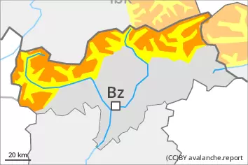
As a consequence of new snow and strong wind there will be an increase in the avalanche danger to level 3 (considerable). Even single winter sport participants can release avalanches easily, in particular on steep west, north and east facing slopes above approximately 2200 m, as well as on very steep sunny slopes at elevated altitudes. Avalanches can in some cases penetrate deep layers and reach large size. Remotely triggered and natural avalanches are possible in isolated cases, especially on very steep shady slopes at high altitude. Caution is to be exercised in particular adjacent to ridgelines, as well as in gullies and bowls, and behind abrupt changes in the terrain. As the snowfall level rises gliding avalanches and moist snow slides are to be expected below approximately 2200 m. Caution and restraint are required.
Snowpack
dp.1: deep persistent weak layer dp.6: cold, loose snow and wind
Up to 20 cm of snow, and even more in some localities, will fall above approximately 2200 m. As a consequence of new snow and a strong to storm force wind from northwesterly directions, avalanche prone wind slabs will form. These will be deposited on a weakly bonded old snowpack in particular on steep shady slopes above approximately 2200 m. Towards its base, the snowpack is faceted and weak. The rain will give rise to gradual and thorough wetting of the snowpack over a wide area below approximately 2000 m.
Tendency
Some snow will fall on Saturday in the north. Wind slabs and weakly bonded old snow represent the main danger.
Danger level
2200m
Avalanche Problem
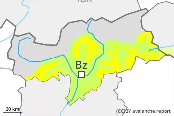
Persistent weak layer
2200m
Wind slab
2600m
Weak layers in the old snowpack represent the main danger.
Weak layers in the old snowpack can still be released by individual winter sport participants. This applies in particular on very steep west, north and east facing slopes above approximately 2200 m, as well as on very steep sunny slopes at elevated altitudes. Caution is to be exercised adjacent to ridgelines, as well as in gullies and bowls, and behind abrupt changes in the terrain. Avalanches can in isolated cases reach medium size. As a consequence of a strong to storm force wind from northwesterly directions, rather small wind slabs will form on Friday, in particular adjacent to ridgelines and in pass areas as well as at elevated altitudes. Meticulous route selection is recommended.
Snowpack
dp.1: deep persistent weak layer dp.6: cold, loose snow and wind
Towards its base, the snowpack is faceted and weak, especially on steep west, north and east facing slopes above approximately 2200 m, as well as on steep sunny slopes at elevated altitudes. Over a wide area strong northwesterly wind. Some snow will fall in particular in the north. The fresh wind slabs will be deposited on soft layers in particular on shady slopes above approximately 2600 m. In the north a little snow is lying.
Tendency
The old snowpack remains prone to triggering. Fresh wind slabs require caution.