For those venturing off piste a precarious avalanche situation will prevail.
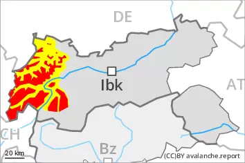
The danger exists primarily in alpine snow sports terrain. As a consequence of mild temperatures, snowfall above approximately 2200 m and the strong to storm force northwesterly wind, a precarious avalanche situation will develop on Christmas Day. Even single freeriders can release avalanches in many places. Avalanches can penetrate down to the ground and reach quite a large size especially in the regions with a lot of snow, especially on shady slopes above approximately 2200 m, and on sunny slopes above approximately 2400 m. Caution is to be exercised in particular adjacent to ridgelines, as well as in gullies and bowls, and behind abrupt changes in the terrain. The avalanche prone locations are difficult to recognise. Remotely triggered avalanches are possible. Great caution and restraint are required. In addition natural avalanches are possible. This applies in all aspects at high altitudes and in high Alpine regions.
All aspects below approximately 2200 m: As the penetration by moisture increases more moist and wet snow slides are possible.
Snowpack
dp.1: deep persistent weak layer dp.3: rain
In particular in the north and in the west over a wide area 30 to 50 cm of snow, and even more in some localities, will fall until Saturday above approximately 2200 m. As a consequence of new snow and a sometimes storm force wind from northwesterly directions, extensive wind slabs will form. These will be deposited on a weakly bonded old snowpack in particular on west to north to east facing aspects above approximately 2200 m. The various wind slabs have bonded poorly together. The rain will give rise to gradual and thorough wetting of the snowpack over a wide area below approximately 2200 m.
Tendency
Sunday: Outside marked and open pistes a precarious avalanche situation will persist. Restraint is advisable on this first sunny day.
Danger level
2200m
Avalanche Problem
Persistent weak layer
2200m
Wind slab
2200m
Wet snow
2200m
Wind slabs and weakly bonded old snow represent the main danger.
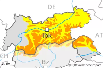
As a consequence of mild temperatures, snowfall above approximately 2200 m and the strong to storm force northwesterly wind, a sometimes precarious avalanche situation will develop on Christmas Day. Even single winter sport participants can release avalanches easily, in particular on steep west, north and east facing slopes above approximately 2200 m, as well as on very steep sunny slopes at elevated altitudes. Avalanches can in some cases penetrate deep layers and reach large size. Caution is to be exercised in particular adjacent to ridgelines, as well as in gullies and bowls, and behind abrupt changes in the terrain. The avalanche prone locations are difficult to recognise. Caution and restraint are required.
As the snowfall level rises gliding avalanches and moist snow slides are possible below approximately 2200 m. This applies in particular on the Main Alpine Ridge and to the north.
Snowpack
dp.1: deep persistent weak layer
In some localities up to 15 cm of snow will fall until Saturday above approximately 2200 m. In the south less snow will fall. Some fresh snow as well as the mostly small wind slabs that are being formed by the strong to storm force northwesterly wind are prone to triggering. The fresh wind slabs will be deposited on a weakly bonded old snowpack in particular on steep shady slopes above approximately 2200 m. The various wind slabs have bonded poorly with each other and the old snowpack. Towards its base, the snowpack is faceted and weak. The rain will give rise to gradual and thorough wetting of the snowpack over a wide area below approximately 2200 m.
Tendency
Wind slabs and weakly bonded old snow represent the main danger. Sunday: Restraint is advisable on this first sunny day.
Danger level
2200m
Avalanche Problem
Persistent weak layer
2200m
Wind slab
2600m
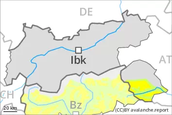
Weak layers in the old snowpack represent the main danger.
In some places avalanches can be triggered in the weakly bonded old snow, in particular on very steep west, north and east facing slopes above approximately 2200 m, as well as on very steep sunny slopes at elevated altitudes. Avalanches can in isolated cases reach medium size. As a consequence of a strong to storm force wind from northwesterly directions, mostly small wind slabs will form on Christmas Day. They are to be evaluated with care and prudence in steep terrain. Caution is to be exercised adjacent to ridgelines and in pass areas, as well as at elevated altitudes. In the regions neighbouring those that are subject to danger level 3 (considerable) the avalanche danger is a little higher.
Snowpack
dp.1: deep persistent weak layer
Towards its base, the snowpack is faceted and weak, especially on steep west, north and east facing slopes above approximately 2200 m, as well as on steep sunny slopes at elevated altitudes. Over a wide area strong northwesterly wind. The fresh wind slabs will be deposited on soft layers in particular on shady slopes above approximately 2600 m. In the north a little snow is lying.
Tendency
Wind slabs and weakly bonded old snow are to be assessed with care and prudence.