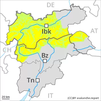
Weakly bonded old snow above approximately 2400 m. Fresh wind slabs require caution.
In some places avalanches can be triggered in the weakly bonded old snow and reach medium size in isolated cases. The avalanche prone locations are to be found in particular on steep northwest to north to northeast facing slopes above approximately 2400 m. These places are rather rare but are difficult to recognise. The prevalence of the avalanche prone locations will increase with altitude. Caution is to be exercised at transitions from a shallow to a deep snowpack. In addition the fresh wind slabs are prone to triggering in isolated cases still. They are to be avoided in particular on very steep shady slopes at elevated altitudes.
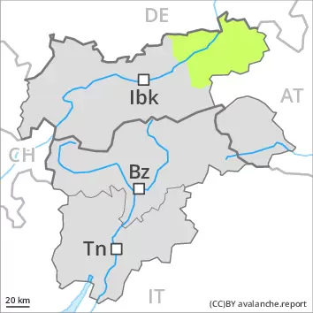
Snowpack
dp.1: deep persistent weak layer dp.6: cold, loose snow and wind
Towards its base, the snowpack is faceted, especially on steep shady slopes above approximately 2400 m, as well as on steep sunny slopes at elevated altitudes. Fresh wind slabs are lying on soft layers in particular on shady slopes above approximately 2400 m. Sunshine and high temperatures will give rise as the day progresses to moistening of the snowpack.
Tendency
On Sunday it will be partly cloudy. Above approximately 1000 m snow will fall from the afternoon in particular in the south. The wind will be strong to storm force. The old snowpack remains prone to triggering in some places. During the first half of the night as a consequence of new snow and wind there will be only a slight increase in the avalanche danger.
Danger level
2400m
Avalanche Problem
Persistent weak layer
2400m
Wet snow
2400m
Weakly bonded old snow is to be evaluated with care and prudence.
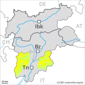
In isolated cases avalanches can be triggered in the weakly bonded old snow and reach medium size. The avalanche prone locations are to be found in particular on steep west to north to east facing slopes above approximately 2400 m and on steep sunny slopes above approximately 2600 m. Caution is to be exercised at transitions from a shallow to a deep snowpack, and at transitions into gullies and bowls. Older wind slabs are mostly small and can be released by large loads in particular, especially adjacent to ridgelines and in pass areas on very steep shady slopes above approximately 2600 m. The prevalence of the avalanche prone locations will increase with altitude. As a consequence of warming during the day and solar radiation individual gliding avalanches and moist snow slides are possible, but they will be mostly small, especially on steep sunny slopes below approximately 2400 m.
Snowpack
dp.1: deep persistent weak layer dp.10: springtime scenario
Towards its base, the snowpack is faceted, especially on steep west, north and east facing slopes above approximately 2000 m, as well as on steep sunny slopes at elevated altitudes. The fresh and older wind slabs are lying on weak layers in particular on shady slopes at elevated altitudes. Towards its surface, the snowpack is hard and its surface has a melt-freeze crust that is strong in many cases, especially below approximately 2400 m on steep sunny slopes. Sunshine and high temperatures will give rise as the day progresses to moistening of the snowpack at low and intermediate altitudes.
Tendency
The avalanche danger will persist.
Danger level
Low avalanche danger will prevail.
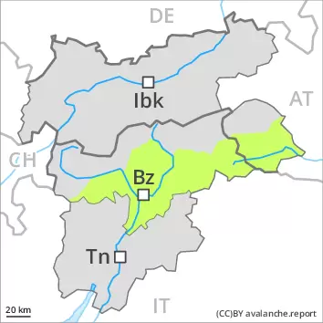
In very isolated cases avalanches can be triggered in the weakly bonded old snow. Such avalanche prone locations are to be found on extremely steep shady slopes above approximately 2400 m. Wind slabs are mostly small and can only be released in isolated cases. Such avalanche prone locations are very rare and are clearly recognisable to the trained eye. Mostly the avalanches are small.
Snowpack
Towards its base, the snowpack is faceted. Fresh wind slabs are lying on soft layers on shady slopes above approximately 2400 m. Sunshine and high temperatures will give rise as the day progresses to moistening of the snowpack.
Tendency
On Sunday it will be cloudy. Above approximately 1000 m snow will fall in the afternoon over a wide area. The wind will be strong to storm force. In the afternoon as a consequence of new snow and wind there will be an increase in the avalanche danger.
Danger level
Low avalanche danger will prevail.
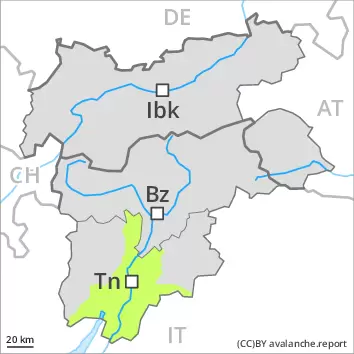
In very isolated cases avalanches can be triggered in the weakly bonded old snow. The avalanche prone locations are to be found in particular on steep west to north to east facing slopes. As a consequence of warming during the day and solar radiation individual moist snow slides are possible. Mostly the avalanches are small.
Snowpack
dp.10: springtime scenario
Over a wide area a little snow is lying. Below approximately 1800 m from a snow sport perspective, in most cases insufficient snow is lying. Towards its base, the snowpack is faceted, especially on steep west, north and east facing slopes. Towards its surface, the snowpack is hard and its surface has a melt-freeze crust that is not capable of bearing a load. Sunshine and high temperatures will give rise as the day progresses to increasing moistening of the snowpack at low and intermediate altitudes.
Tendency
The avalanche danger will persist.
Danger level
Low avalanche danger will prevail.
Winter sport participants can release avalanches now only rarely. Individual gliding avalanches and snow slides are possible. This applies on steep grassy slopes.
Snowpack
The snowpack will be stable. Only a small amount of snow is lying for the time of year.
Tendency
On Sunday it will be partly cloudy. The wind will be strong to storm force. The avalanche danger will increase but remain within the current danger level.