As a consequence of new snow and stormy weather a treacherous avalanche situation will prevail. New snow, wind slabs and old snow require caution.
In all aspects avalanches can be released easily and reach large size in isolated cases. The avalanche prone locations are to be found in all aspects above the tree line. These places are difficult to recognise. The prevalence of the avalanche prone locations will increase with altitude. Caution is to be exercised at transitions from a shallow to a deep snowpack. As a consequence of a strong to storm force northerly wind, avalanche prone wind slabs will form in the course of the day. More recent wind slabs are to be avoided in all aspects. Caution is to be exercised in particular on very steep slopes, and adjacent to ridgelines. Individual natural avalanches are possible as the day progresses.
Snowpack
dp.1: deep persistent weak layer dp.6: cold, loose snow and wind
10 to 30 cm of snow, and even more in some localities, has fallen. Over a wide area storm force wind. Faceted weak layers exist in the bottom section of the snowpack at elevated altitudes. Faceted weak layers exist in the top section of the snowpack especially on shady slopes. Fresh wind slabs are lying on soft layers at elevated altitudes. The snowpack will be prone to triggering above the tree line.
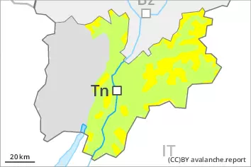
Tendency
The avalanche danger will persist. Some snow will fall on Wednesday over a wide area.
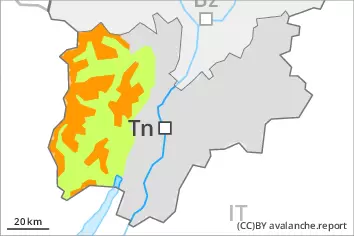
Danger level
treeline
Avalanche Problem
Persistent weak layer
Treeline
Wind slab
Treeline
New snow, wind slabs and old snow require caution. As a consequence of new snow and stormy weather a treacherous avalanche situation will prevail.
In all aspects avalanches can be released easily and reach large size in isolated cases. The avalanche prone locations are to be found in all aspects above the tree line. These places are difficult to recognise. The prevalence of the avalanche prone locations will increase with altitude. Caution is to be exercised at transitions from a shallow to a deep snowpack. As a consequence of a strong to storm force northerly wind, avalanche prone wind slabs will form in the course of the day. More recent wind slabs are to be avoided in all aspects. Caution is to be exercised in particular on very steep slopes, and adjacent to ridgelines. Individual natural avalanches are possible as the day progresses.
Snowpack
dp.1: deep persistent weak layer dp.6: cold, loose snow and wind
5 to 20 cm of snow, and even more in some localities, has fallen. Over a wide area storm force wind. Faceted weak layers exist in the bottom section of the snowpack at elevated altitudes. Faceted weak layers exist in the top section of the snowpack especially on shady slopes. Fresh wind slabs are lying on soft layers at elevated altitudes. The snowpack will be prone to triggering above the tree line.
Tendency
The avalanche danger will persist. Some snow will fall on Wednesday over a wide area.