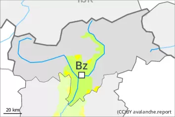
Danger level
 | treeline |
|  |
|  | ||||
| |
|  |


![]()
Wind slabs and weakly bonded old snow represent the main danger.
The new snow and wind slabs of the last few days can be released by a single winter sport participant. Avalanches can penetrate even deep layers and reach medium size. The avalanche prone locations are to be found in all aspects. They are covered with new snow and are difficult to recognise. Caution is to be exercised in particular on very steep shady slopes above approximately 2200 m, as well as on very steep sunny slopes at elevated altitudes. Whumpfing sounds and the formation of shooting cracks when stepping on the snowpack can indicate the danger. The prevalence of the avalanche prone locations will increase with altitude. In the afternoon as a consequence of the snowfall there will be an increase in the avalanche danger to level 3 (considerable).
Meticulous route selection is recommended.
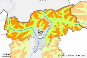
Snowpack
dp.6: cold, loose snow and wind
dp.1: deep persistent weak layer
In some regions up to 20 cm of snow, and even more in some localities, has fallen since Sunday. The fresh snow and the wind slabs formed by the strong to storm force wind are lying on the unfavourable surface of an old snowpack.
Over a wide area 5 to 15 cm of snow will fall from the afternoon. In the southeast more snow will fall. The snowpack will become increasingly prone to triggering.
Faceted weak layers exist in the old snowpack. This applies in all aspects above approximately 2200 m, especially on west, north and east facing slopes above approximately 2400 m.
Tendency
On Wednesday it will be partly cloudy. Some snow will fall until midday in some regions, in particular in the east. The wind will be light to moderate. The avalanche danger will persist.