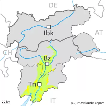
Wind slabs and weakly bonded old snow represent the main danger.
As a consequence of a gathering storm force wind, avalanche prone wind slabs will form at elevated altitudes. The fresh wind slabs can be released even by a single winter sport participant. Mostly avalanches are medium-sized. The avalanche prone locations are to be found in all aspects above approximately 2200 m, in particular in gullies and bowls, and behind abrupt changes in the terrain. Additionally avalanches can also be released in the old snowpack. Such avalanche prone locations are to be found on steep, little used shady slopes above approximately 2200 m and on steep sunny slopes above approximately 2500 m. Backcountry touring and other off-piste activities call for careful route selection.
Snowpack
dp.6: cold, loose snow and wind dp.1: deep persistent weak layer
Some snow will fall on Saturday. As a consequence of new snow and a sometimes storm force wind from northeasterly directions, further wind slabs will form. The fresh and older wind slabs are lying on the unfavourable surface of an old snowpack. These are mostly small but in some cases prone to triggering. Faceted weak layers exist in the old snowpack, especially on shady slopes above approximately 2200 m, as well as on sunny slopes above approximately 2500 m. Field observations confirm that the stability of the snowpack varies greatly within a small area.
Tendency
As a consequence of low temperatures the snowpack can not consolidate on Sunday. The snowpack remains prone to triggering in some places.
Danger level
treeline
Avalanche Problem
Wind slab
Treeline
Persistent weak layer
2200m
Considerable avalanche danger will persist. Wind slabs and weakly bonded old snow represent the main danger.
As a consequence of a gathering storm force northeasterly wind, avalanche prone wind slabs will form over a wide area. The fresh wind slabs can be released easily, even by a single winter sport participant,. Mostly avalanches are medium-sized. The avalanche prone locations are to be found in all aspects above the tree line. At elevated altitudes and in the regions exposed to the foehn wind the avalanche prone locations are more prevalent. Remotely triggered avalanches are possible. Individual natural avalanches are not ruled out. Additionally avalanches can also be released in deep layers. Such avalanche prone locations are to be found on steep, little used shady slopes above approximately 2200 m and on steep sunny slopes above approximately 2500 m. Backcountry touring and other off-piste activities call for caution and restraint.
Snowpack
dp.6: cold, loose snow and wind dp.1: deep persistent weak layer
In particular in the northeast up to 10 cm of snow will fall on Saturday. In the south less snow will fall. As a consequence of a gathering storm force wind from northeasterly directions, further wind slabs will form. These will be deposited on soft layers. The snowpack will become increasingly prone to triggering. Whumpfing sounds and the formation of shooting cracks when stepping on the snowpack are a clear indication. Faceted weak layers exist in the old snowpack, especially on shady slopes above approximately 2200 m, as well as on sunny slopes above approximately 2500 m.
Tendency
As a consequence of low temperatures the snowpack can not consolidate on Sunday. The snowpack remains prone to triggering in some places. Considerable avalanche danger will persist.
Danger level
treeline
Avalanche Problem
Wind slab
Treeline
Persistent weak layer
2200m
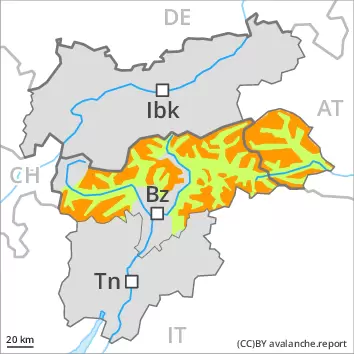
Increase in danger as a consequence of new snow and strong wind. Wind slabs and weakly bonded old snow represent the main danger.
As a consequence of new snow and a gathering strong northeasterly wind, avalanche prone wind slabs will form from the middle of the day over a wide area. The fresh wind slabs can be released easily, even by a single winter sport participant,. The wind slabs will be covered with new snow in some cases and therefore difficult to recognise. Mostly avalanches are medium-sized. The avalanche prone locations are to be found in all aspects above the tree line, in particular adjacent to ridgelines and in pass areas, as well as in gullies and bowls, and behind abrupt changes in the terrain. At elevated altitudes the avalanche prone locations are more prevalent. Individual natural avalanches are not ruled out. Additionally avalanches can also be triggered in deep layers. Such avalanche prone locations are to be found on steep, little used shady slopes above approximately 2200 m and on steep sunny slopes above approximately 2500 m. Backcountry touring and other off-piste activities call for experience in the assessment of avalanche danger and careful route selection.
Snowpack
dp.6: cold, loose snow and wind dp.1: deep persistent weak layer
Over a wide area 20 to 30 cm of snow, and even more in some localities, will fall. As a consequence of a gathering strong wind from northeasterly directions, extensive wind slabs formed in the last few days. These will be deposited on soft layers. The snowpack will become increasingly prone to triggering. Faceted weak layers exist in the old snowpack, especially on shady slopes above approximately 2200 m, as well as on sunny slopes above approximately 2500 m. Stability tests and field observations confirm that the stability of the snowpack varies greatly within a small area.
Tendency
As a consequence of low temperatures and the occasionally strong northeasterly wind, the snowpack can not consolidate. Above the tree line a considerable avalanche danger will be encountered over a wide area.
Danger level
treeline
Avalanche Problem
Wind slab
Treeline
Persistent weak layer
2200m
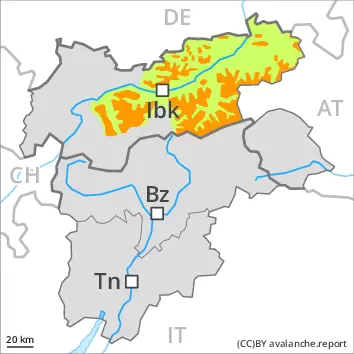
The fresh snow as well as the wind slabs represent the main danger. Weakly bonded old snow above approximately 2200 m.
As a consequence of a strong to storm force northeasterly wind, avalanche prone wind slabs will form over a wide area. The fresh wind slabs can be released easily, even by a single winter sport participant,. Mostly avalanches are medium-sized. The avalanche prone locations are to be found in all aspects above the tree line. At elevated altitudes and in the regions exposed to the foehn wind the avalanche prone locations are more prevalent and the danger is greater. Some natural avalanches are possible. Remotely triggered avalanches are possible in isolated cases. Avalanches can also be released in deep layers. Such avalanche prone locations are to be found on steep, little used shady slopes above approximately 2200 m and on steep sunny slopes above approximately 2500 m. Backcountry touring and other off-piste activities call for caution and restraint.
Snowpack
dp.6: cold, loose snow and wind dp.1: deep persistent weak layer
Some snow has fallen since Thursday in some regions, in particular in the northeast. The new snow and wind slabs of the last few days are poorly bonded with the old snowpack. As a consequence of a gathering strong wind from northeasterly directions, extensive wind slabs will form from early morning. These will be deposited on soft layers. The snowpack will become increasingly prone to triggering. Faceted weak layers exist in the old snowpack, especially on shady slopes above approximately 2200 m, as well as on sunny slopes above approximately 2500 m.
Tendency
As a consequence of low temperatures the snowpack can not consolidate on Sunday. The snowpack will become prone to triggering over a wide area. Considerable avalanche danger will be encountered over a wide area. The avalanche danger will persist.
Danger level
treeline
Avalanche Problem
Wind slab
Treeline
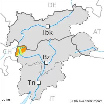
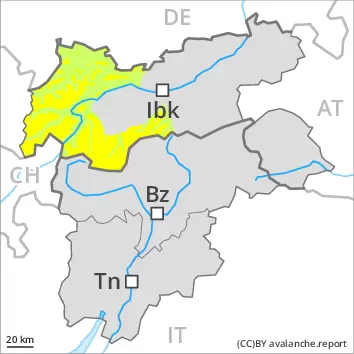
Fresh wind slabs are to be evaluated with care and prudence. Moderate avalanche danger will persist.
As a consequence of a strong northeasterly wind, avalanche prone wind slabs will form by the evening over a wide area. The various wind slabs of the last few days can be released by a single winter sport participant in all aspects. The avalanche prone locations are to be found in particular in steep terrain and adjacent to ridgelines and in gullies and bowls. Avalanches can additionally be released in the old snowpack in isolated cases. These avalanche prone locations are rare and are difficult to recognise. In regions neighbouring those that are subject to danger level 3 (considerable) the avalanche prone locations are more prevalent. Experience in the assessment of avalanche danger is required. Meticulous route selection is recommended.
Snowpack
dp.6: cold, loose snow and wind
As a consequence of a gusty wind from northeasterly directions, further wind slabs will form on Saturday. The new snow and wind slabs of the last few days are poorly bonded with the old snowpack. The snowpack is soft and its surface has a crust that is not capable of bearing a load. Isolated avalanche prone weak layers exist in the old snowpack, especially on steep, little used shady slopes. These are mostly small and in some cases prone to triggering.
Tendency
As a consequence of low temperatures the snowpack can not consolidate on Sunday. The snowpack remains prone to triggering in some places. The avalanche danger will persist.
Danger level
treeline
Avalanche Problem
Wind slab
Treeline
Persistent weak layer
2200m
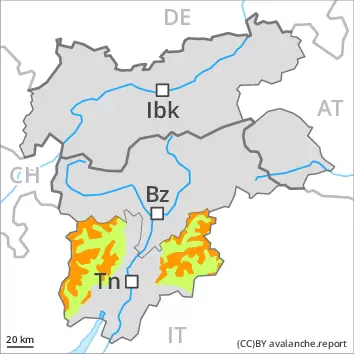
The fresh wind slabs represent the main danger. Weakly bonded old snow above approximately 2200 m.
As a consequence of a strengthening northeasterly wind, avalanche prone wind slabs will form in some places. The fresh wind slabs can be released even by a single winter sport participant. Avalanches can reach medium size. The avalanche prone locations are to be found in all aspects above the tree line, in particular adjacent to ridgelines and in pass areas, as well as in gullies and bowls, and behind abrupt changes in the terrain. Additionally avalanches can also be released in the old snowpack. These avalanche prone locations are to be found on steep, little used shady slopes above approximately 2200 m and on steep sunny slopes above approximately 2500 m. The number and size of avalanche prone locations will increase with altitude. Meticulous route selection is advisable.
Snowpack
dp.6: cold, loose snow and wind dp.1: deep persistent weak layer
In some localities up to 10 cm of snow will fall on Saturday. As a consequence of a strengthening wind from northeasterly directions, further wind slabs will form in the course of the day. The new snow and wind slabs of the last few days are poorly bonded with the old snowpack in some places. These are mostly small but in some cases prone to triggering. Faceted weak layers exist in the old snowpack, especially on shady slopes above approximately 2200 m, as well as on sunny slopes above approximately 2500 m. Field observations show that the stability of the snowpack varies greatly within a small area.
Tendency
Sunday: Over a wide area some new snow. In some regions moderate northeasterly wind. The avalanche danger will persist.