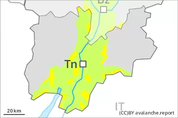
Danger level
 | treeline |
|  |
|  | ||||
| |
| |


![]()
The fresh snow as well as the wind slabs represent the main danger. Weakly bonded old snow above approximately 2200 m.
As a consequence of a strong to storm force northeasterly wind, avalanche prone wind slabs will form over a wide area. The fresh wind slabs can be released easily, even by a single winter sport participant,. Mostly avalanches are medium-sized. The avalanche prone locations are to be found in all aspects above the tree line. At elevated altitudes and in the regions exposed to the foehn wind the avalanche prone locations are more prevalent and the danger is greater. Some natural avalanches are possible. Remotely triggered avalanches are possible in isolated cases.
Avalanches can also be released in deep layers. Such avalanche prone locations are to be found on steep, little used shady slopes above approximately 2200 m and on steep sunny slopes above approximately 2500 m.
Backcountry touring and other off-piste activities call for caution and restraint.
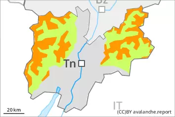
Snowpack
dp.6: cold, loose snow and wind
dp.1: deep persistent weak layer
Some snow has fallen since Thursday in some regions, in particular in the northeast. The new snow and wind slabs of the last few days are poorly bonded with the old snowpack. As a consequence of a gathering strong wind from northeasterly directions, extensive wind slabs will form from early morning. These will be deposited on soft layers. The snowpack will become increasingly prone to triggering.
Faceted weak layers exist in the old snowpack, especially on shady slopes above approximately 2200 m, as well as on sunny slopes above approximately 2500 m.
Tendency
As a consequence of low temperatures the snowpack can not consolidate on Sunday. The snowpack will become prone to triggering over a wide area. Considerable avalanche danger will be encountered over a wide area. The avalanche danger will persist.