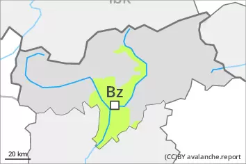
Danger level
 | treeline |
|  |
|  | ||||
| |
| |


![]()
Considerable avalanche danger will persist. Wind slabs and weakly bonded old snow represent the main danger.
As a consequence of a strong to storm force wind from northerly directions, avalanche prone wind slabs formed since Friday over a wide area. The fresh wind slabs can be released easily, even by a single winter sport participant,. Mostly avalanches are medium-sized. The avalanche prone locations are to be found in all aspects above the tree line. They are barely recognisable because of the poor visibility. At elevated altitudes the avalanche prone locations are more prevalent. Remotely triggered avalanches are possible in isolated cases.
Additionally avalanches can also be released in deep layers. Such avalanche prone locations are to be found on steep, little used shady slopes above approximately 2200 m and on steep sunny slopes above approximately 2500 m. Especially transitions from a shallow to a deep snowpack are unfavourable.
Backcountry touring and other off-piste activities call for caution and restraint.
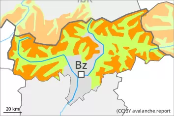
Snowpack
dp.6: cold, loose snow and wind
dp.1: deep persistent weak layer
In the north and in the northeast 5 to 10 cm of snow, and even more in some localities, has fallen. The wind was strong to storm force. Fresh wind slabs are lying on weak layers in all aspects above the tree line.
Faceted weak layers exist in the old snowpack, especially on shady slopes above approximately 2200 m, as well as on sunny slopes above approximately 2500 m.
The snowpack remains quite prone to triggering. Whumpfing sounds and the formation of shooting cracks when stepping on the snowpack are a clear indication.
Tendency
Considerable avalanche danger will persist.
Some snow will fall on Monday especially in the south. The wind will be strong in some regions. Fresh wind slabs represent the main danger.