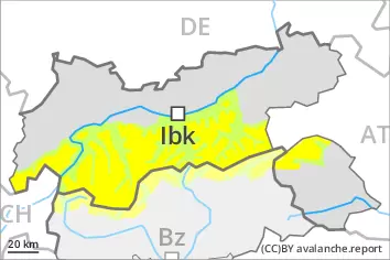
Weakly bonded old snow above approximately 2200 m.
Weak layers in the old snowpack can be released even now by individual winter sport participants, especially on the Main Alpine Ridge and to the north. The avalanche prone locations are to be found in particular on steep, little used west, north and east facing slopes above approximately 2200 m and at transitions from a shallow to a deep snowpack. These places are rare but are difficult to recognise. Mostly avalanches are medium-sized. Careful route selection is recommended.
Snowpack
dp.1: deep persistent weak layer
The snowpack consists of faceted crystals and its surface has a melt-freeze crust that is strong in many cases. The solar radiation will give rise as the day progresses to slight moistening of the snowpack. Isolated avalanche prone weak layers exist in the centre of the snowpack in particular on very steep west, north and east facing slopes, especially between approximately 2200 and 2600 m. Some snow will fall on Friday in some regions. The moderate wind will transport only a little snow. In steep terrain there is a danger of falling on the hard snow surface. The snowpack will be subject to considerable local variations above the tree line. Over a wide area only a small amount of snow is lying for the time of year.
Tendency
5 to 15 cm of snow will fall on Saturday, in particular on the Main Alpine Ridge and to the north. For this reason the danger of dry avalanches will increase a little.
Danger level
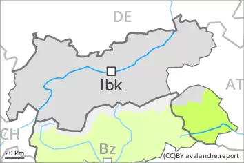
Currently there are favourable conditions generally.
Single winter sport participants can release avalanches only in isolated cases. The avalanche prone locations for dry avalanches are to be found in particular on extremely steep shady slopes and at transitions from a shallow to a deep snowpack. They are very rare but are difficult to recognise. In many places there is a danger of falling on the hard snow surface.
Snowpack
dp.1: deep persistent weak layer
The snowpack is largely stable and its surface has a crust that is strong in many cases. The solar radiation will give rise as the day progresses to slight moistening of the snowpack. In very isolated cases weak layers exist in the centre of the snowpack, especially on shady slopes above approximately 2200 m, and on sunny slopes at elevated altitudes. The snowpack will be subject to considerable local variations above the tree line. Over a wide area only a small amount of snow is lying for the time of year.
Tendency
On Saturday the wind will be strong in some cases. The backcountry touring conditions remain mostly favourable.
Danger level
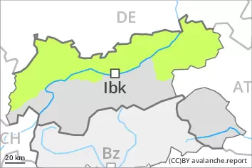
Currently there are favourable conditions generally.
Single winter sport participants can release avalanches only in isolated cases. The avalanche prone locations for dry avalanches are to be found in particular on extremely steep shady slopes and at transitions from a shallow to a deep snowpack. They are very rare but are difficult to recognise. In many places there is a danger of falling on the hard snow surface.
Snowpack
dp.1: deep persistent weak layer
The snowpack is largely stable and its surface has a crust that is strong in many cases. Some snow will fall in some regions. In very isolated cases weak layers exist in the centre of the snowpack, especially on shady slopes above approximately 2200 m. The snowpack will be subject to considerable local variations above the tree line. Over a wide area only a small amount of snow is lying for the time of year.
Tendency
20 to 30 cm of snow will fall on Saturday. For this reason the danger of dry avalanches will increase.