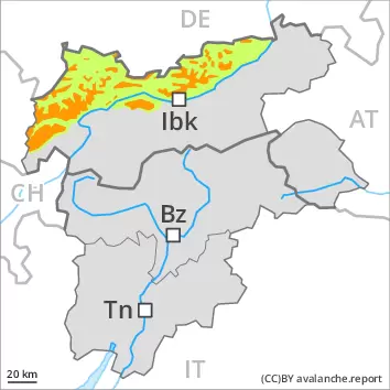
New snow and wind slabs represent the main danger.
Avalanches are possible in particular above the tree line. This applies in all aspects. These can in many cases be released, even by a single winter sport participant and reach medium size. As a consequence of new snow and wind the prevalence and size of the avalanche prone locations will increase. They will be covered with new snow in some cases and therefore difficult to recognise. In the regions exposed to heavier precipitation the avalanche danger is a little higher. Avalanches can additionally in isolated cases be released in the weakly bonded old snow also. These avalanche prone locations are to be found in particular on extremely steep shady slopes and at transitions from a shallow to a deep snowpack. They are very rare but are difficult to recognise. Single winter sport participants can release avalanches only in isolated cases. Careful route selection is recommended.
Snowpack
dp.6: cold, loose snow and wind dp.1: deep persistent weak layer
20 to 40 cm of snow, and even more in some localities, fell on Saturday. Over a wide area 5 to 15 cm of snow will fall on Sunday. As a consequence of new snow and a moderate to strong wind from variable directions, further wind slabs will form in all aspects, in particular above the tree line. In very isolated cases weak layers exist in the centre of the snowpack, especially on shady slopes above approximately 2200 m.
Tendency
In some cases the various wind slabs have bonded still only poorly with each other and the old snowpack. The weather conditions will bring about a slow change towards better conditions.
Danger level
1600m
Avalanche Problem
Wind slab
1600m
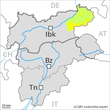
Fresh wind slabs represent the main danger.
The fresh and older wind slabs are to be evaluated with care and prudence in all aspects above approximately 1600 m. These are in some cases extensive and can be released easily. Mostly avalanches are medium-sized. In the regions exposed to heavier precipitation the avalanche danger is a little higher.
Snowpack
dp.6: cold, loose snow and wind dp.1: deep persistent weak layer
20 to 30 cm of snow, and even more in some localities, has fallen since Saturday. Up to 15 cm of snow will fall on Sunday in all altitude zones. As a consequence of new snow and a moderate to strong wind from variable directions, further wind slabs will form in all aspects, in particular above approximately 1600 m. In very isolated cases weak layers exist in the centre of the snowpack, especially on shady slopes above approximately 2200 m.
Tendency
In some cases the various wind slabs have bonded still only poorly with each other and the old snowpack. The weather conditions will bring about a slow change towards better conditions.
Danger level
treeline
Avalanche Problem
Wind slab
Treeline
Persistent weak layer
2200m
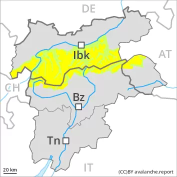
Fresh wind slabs are to be evaluated with care and prudence. Weakly bonded old snow above approximately 2200 m.
The fresh and older wind slabs are to be evaluated with care and prudence in all aspects above the tree line. These can be released by a single winter sport participant and reach medium size. Weak layers in the old snowpack can be released even now by individual winter sport participants, especially on the Main Alpine Ridge and to the north. The avalanche prone locations are to be found in particular on steep, little used west, north and east facing slopes above approximately 2200 m and at transitions from a shallow to a deep snowpack. These places are rare but are difficult to recognise. Mostly avalanches are medium-sized. Careful route selection is recommended.
Snowpack
dp.6: cold, loose snow and wind dp.1: deep persistent weak layer
5 to 15 cm of snow will fall on Sunday, in particular on the Main Alpine Ridge and to the north. As a consequence of new snow and a moderate to strong wind from variable directions, avalanche prone wind slabs will form in all aspects. In some cases the various wind slabs have bonded still only poorly with each other and the old snowpack. The snowpack will be subject to considerable local variations above the tree line. Isolated avalanche prone weak layers exist in the centre of the snowpack in particular on very steep west, north and east facing slopes, especially between approximately 2200 and 2600 m.
Tendency
In some cases the various wind slabs have bonded still only poorly with each other and the old snowpack. The weather conditions will bring about a slow change towards better conditions.
Danger level
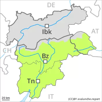
Currently there are favourable conditions generally.
Single winter sport participants can release avalanches only in isolated cases. The avalanche prone locations for dry avalanches are to be found in particular on extremely steep shady slopes and at transitions from a shallow to a deep snowpack. They are very rare but are difficult to recognise. In many places there is a danger of falling on the hard snow surface.
Snowpack
dp.1: deep persistent weak layer
The snowpack is largely stable and its surface has a crust that is strong in many cases. The solar radiation will give rise as the day progresses to slight moistening of the snowpack, especially at low and intermediate altitudes. In very isolated cases weak layers exist in the centre of the snowpack, especially on shady slopes above approximately 2200 m, and on sunny slopes at elevated altitudes. The snowpack will be subject to considerable local variations above the tree line. Over a wide area only a small amount of snow is lying for the time of year.
Tendency
The backcountry touring conditions remain mostly favourable.