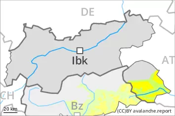
Wind slabs and weakly bonded old snow represent the main danger.
Avalanches can be released in the old snowpack, even by a single winter sport participant, especially on very steep shady slopes above approximately 2200 m, as well as on very steep east and west facing slopes above approximately 2400 m. Caution is to be exercised at transitions from a shallow to a deep snowpack. As the day progresses the likelihood of avalanches being released will increase a little. Avalanches can reach medium size. In addition the wind slabs of the last few days are capable of being triggered in some cases still, in particular on very steep shady slopes above approximately 2400 m, as well as adjacent to ridgelines and in pass areas. At elevated altitudes the avalanche prone locations are more prevalent. As a consequence of warming during the day and solar radiation small to medium-sized wet avalanches are to be expected. Backcountry touring calls for careful route selection.
Snowpack
dp.1: deep persistent weak layer dp.6: cold, loose snow and wind
The new snow and wind slabs of the last few days are lying on soft layers in particular on steep shady slopes at elevated altitudes. The wind slabs are in some cases still prone to triggering above approximately 2400 m. Faceted weak layers exist in the old snowpack, especially on shady slopes above approximately 2200 m, as well as on east and west facing slopes above approximately 2400 m. Sunshine and high temperatures will give rise as the day progresses to increasing moistening of the snowpack. These conditions will bring about a gradual weakening of the snowpack in particular on steep sunny slopes.
Tendency
Significant warming. Increase in danger of wet avalanches in the course of the day.
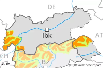
Danger level
2000m
Avalanche Problem
Persistent weak layer
2000m
Wind slab
2400m
Weakly bonded old snow represents the main danger. Wind slabs and wet snow require caution.
Weak layers in the old snowpack can be released even by individual winter sport participants. This applies in particular on very steep shady slopes above approximately 2000 m, as well as on very steep east and west facing slopes above approximately 2400 m. Avalanches can reach medium size. Caution is to be exercised at transitions from a shallow to a deep snowpack. As the day progresses the likelihood of avalanches being released will increase a little. In addition the wind slabs of the last few days are capable of being triggered in some cases still. Such avalanche prone locations are to be found in particular on very steep shady slopes above approximately 2400 m, especially adjacent to ridgelines. As a consequence of warming during the day and solar radiation small to medium-sized loose snow avalanches are to be expected.
Snowpack
dp.1: deep persistent weak layer dp.6: cold, loose snow and wind
Faceted weak layers exist in the old snowpack, especially on shady slopes above approximately 2000 m, as well as on west and east facing slopes above approximately 2400 m. The wind slabs of the last few days are lying on soft layers especially on shady slopes at elevated altitudes. Sunshine and high temperatures will give rise to increasing moistening of the snowpack especially on sunny slopes. These conditions will bring about a gradual weakening of the snowpack as the day progresses.
Tendency
Friday: Increase in danger of moist and wet avalanches as a consequence of warming.
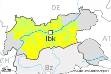
Danger level
2400m
Avalanche Problem
Wind slab
2400m
Wind slabs require caution. Slight increase in danger of wet avalanches as a consequence of warming.
The fresh wind slabs can in isolated cases be released. This applies on very steep shady slopes at elevated altitudes, and adjacent to ridgelines. Mostly the avalanches are small. In steep rocky terrain mostly small loose snow avalanches are to be expected as a consequence of warming. As a consequence of warming during the day and solar radiation mostly small moist and wet avalanches are possible.
Snowpack
dp.6: cold, loose snow and wind dp.10: springtime scenario
In some regions up to 10 cm of snow fell during the night. As a consequence of the moderate northwesterly wind, fresh snow drift accumulations formed. Sunshine and high temperatures will give rise as the day progresses to increasing moistening of the snowpack.
Tendency
Friday: Gradual increase in danger of moist and wet avalanches as a consequence of warming.
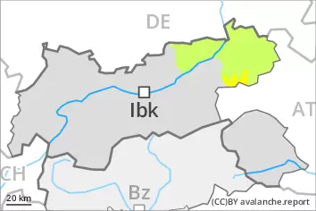
Danger level
2200m
Avalanche Problem
Persistent weak layer
2200m
Wind slab
2400m
Weakly bonded old snow requires caution. Wind slabs at elevated altitudes.
In isolated cases avalanches can be triggered in the faceted old snow and reach medium size, especially on very steep shady slopes above approximately 2200 m, as well as on very steep east and west facing slopes above approximately 2400 m. Caution is to be exercised at transitions from a shallow to a deep snowpack. As the day progresses the likelihood of avalanches being released will increase a little. In addition the wind slabs of the last few days are capable of being triggered in isolated cases still, in particular on very steep slopes at elevated altitudes, and adjacent to ridgelines. On sunny slopes mostly small wet avalanches are to be expected as a consequence of warming during the day and solar radiation.
Snowpack
dp.1: deep persistent weak layer dp.6: cold, loose snow and wind
Faceted weak layers exist in the old snowpack, especially on shady slopes above approximately 2200 m, as well as on east and west facing slopes above approximately 2400 m. The wind slabs are in individual cases still prone to triggering above approximately 2400 m. Sunshine and high temperatures will give rise as the day progresses to increasing moistening of the snowpack. These conditions will bring about a gradual weakening of the snowpack in particular on steep sunny slopes.
Tendency
Significant warming. Increase in danger of wet avalanches in the course of the day.