Weakly bonded old snow is to be evaluated with care and prudence. Increase in avalanche danger as a consequence of solar radiation.
Weak layers in the old snowpack can still be released in very isolated cases, this applies even in case of a single winter sport participant. Caution is to be exercised in particular on very steep shady slopes above approximately 2200 m, as well as on very steep east facing slopes above approximately 2400 m, especially on little used northeast and east facing slopes. Night: As a consequence of the rain small natural wet avalanches are possible below approximately 2200 m. This applies in particular on shady slopes. As the day progresses the likelihood of wet avalanches being released will increase. As a consequence of solar radiation, the natural avalanche activity will increase. This applies in particular on very steep east, south and west facing slopes below approximately 2400 m.
Snowpack
dp.1: deep persistent weak layer
Up to 2000 m rain will fall in the next few hours. In some localities up to 15 cm of snow will fall above approximately 2000 m.
Faceted weak layers exist in the old snowpack, especially on shady slopes above approximately 2200 m, as well as on east and west facing slopes above approximately 2400 m.
Outgoing longwave radiation during the night will be reduced in some case. The surface of the snowpack is frozen, but not to a significant depth and will soften during the day, in particular at intermediate altitudes. Hardly any snow is lying at low altitude. The snowpack will be moist at low and intermediate altitudes.
Tendency
Tuesday: Hardly any increase in avalanche danger as a consequence of warming during the day.
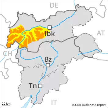
Danger level
2200m
Avalanche Problem
Persistent weak layer
2200m
Weakly bonded old snow is to be evaluated with care and prudence. Wet avalanches as the day progresses.
Weak layers in the old snowpack can be released even now by winter sport participants, especially on very steep shady slopes above approximately 2200 m, as well as on very steep east and west facing slopes above approximately 2400 m. The avalanches can be released in the weakly bonded old snow and reach medium size. Caution is to be exercised on little used northeast and east facing slopes. As the day progresses the likelihood of wet avalanches being released will increase, in particular on sunny slopes below approximately 2600 m. Backcountry tours should be concluded timely.
Snowpack
dp.1: deep persistent weak layer
Faceted weak layers exist in the old snowpack, especially on shady slopes above approximately 2200 m, as well as on east and west facing slopes above approximately 2400 m. Outgoing longwave radiation during the night will be reduced in some case. The surface of the snowpack is frozen, but not to a significant depth and will soften during the day. These weather conditions will bring about a weakening of the snowpack as the day progresses.
Tendency
The danger of dry avalanches will decrease gradually. As the day progresses as a consequence of warming during the day and solar radiation there will be only a slight increase in the danger of wet avalanches.
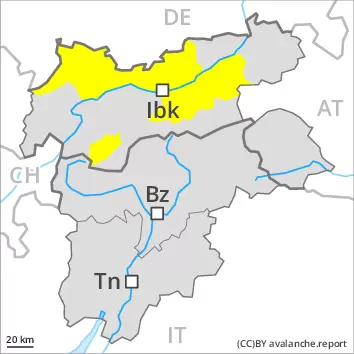
Danger level
2200m
Avalanche Problem
Persistent weak layer
2200m
Wet snow
2200m
Weakly bonded old snow is to be evaluated with care and prudence.
Weak layers in the old snowpack can still be released in very isolated cases, this applies even in case of a single winter sport participant. Caution is to be exercised in particular on very steep shady slopes above approximately 2200 m, as well as on very steep east facing slopes above approximately 2400 m, especially on little used northeast and east facing slopes. Night: As a consequence of the rain small natural wet avalanches are possible below approximately 2200 m. This applies in particular on shady slopes. As the day progresses the likelihood of wet avalanches being released will increase a little. This applies in particular on very steep east, south and west facing slopes below approximately 2400 m.
Snowpack
dp.1: deep persistent weak layer
Up to 2000 m rain will fall in the next few hours. In some localities up to 15 cm of snow will fall above approximately 2000 m.
Faceted weak layers exist in the old snowpack, especially on shady slopes above approximately 2200 m, as well as on east and west facing slopes above approximately 2400 m.
Outgoing longwave radiation during the night will be reduced in some case. The surface of the snowpack is frozen, but not to a significant depth and will soften during the day, in particular at intermediate altitudes. Hardly any snow is lying at low altitude.
Tendency
Tuesday: Hardly any increase in avalanche danger as a consequence of warming during the day.
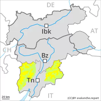
Danger level
2200m
Avalanche Problem
Persistent weak layer
2200m
Wet snow
Treeline
Weakly bonded old snow is to be evaluated with care and prudence. As the day progresses, individual snow slides are possible.
As a consequence of a strong wind from northwesterly directions, sometimes avalanche prone wind slabs formed on Wednesday in particular adjacent to ridgelines and in gullies and bowls. At elevated altitudes the avalanche prone locations are more prevalent. At transitions from a shallow to a deep snowpack the likelihood of avalanches being released is greater. Avalanches can be released in the old snowpack, even by small loads in isolated cases. This applies in particular on very steep shady slopes. Caution is to be exercised at transitions from a shallow to a deep snowpack. As a consequence of warming during the day and solar radiation individual mostly small moist snow slides are to be expected as the day progresses. This applies in particular on sunny slopes, as well as on shady slopes below approximately 2200 m.
Snowpack
In some cases the wind slabs have bonded still only poorly with the old snowpack. In some places wind slabs are lying on a hard crust. Individual weak layers exist in the old snowpack in particular on shady slopes. This applies above approximately 2200 m. The solar radiation will give rise as the day progresses to gradual moistening of the snowpack in particular on sunny slopes. These conditions will bring about a weakening of the snowpack.
Tendency
On Tuesday it will be sunny. Gradual increase in avalanche danger as a consequence of warming during the day and solar radiation.
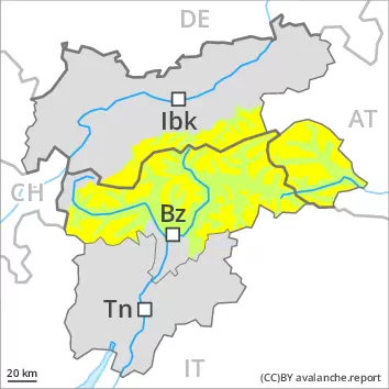
Danger level
2200m
Avalanche Problem
Persistent weak layer
2200m
Weakly bonded old snow is to be evaluated with care and prudence.
Weak layers in the old snowpack can still be released by individual winter sport participants. This applies in particular on very steep shady slopes above approximately 2200 m, as well as on very steep east and west facing slopes above approximately 2400 m. Caution is to be exercised on little used shady slopes. In addition the older wind slabs at high altitudes and in high Alpine regions are capable of being triggered in isolated cases still. As the day progresses the likelihood of wet avalanches being released will increase, in particular on sunny slopes below approximately 2600 m. Backcountry tours should be concluded timely.
Snowpack
dp.1: deep persistent weak layer
Faceted weak layers exist in the old snowpack, especially on shady slopes above approximately 2200 m, as well as on east and west facing slopes above approximately 2400 m. The old wind slabs are in individual cases still prone to triggering at high altitudes and in high Alpine regions. Outgoing longwave radiation during the night will be reduced in some case. The surface of the snowpack is frozen, but not to a significant depth and will soften during the day. The weather conditions will bring about a slight weakening of the snowpack as the day progresses.
Tendency
The danger of dry avalanches will decrease gradually. As the day progresses as a consequence of warming during the day and solar radiation there will be only a slight increase in the danger of wet avalanches.
Danger level
Currently there are favourable avalanche conditions mostly.
Individual avalanche prone locations are to be found in particular on steep, little used shady slopes at high altitude.
Snowpack
The snowpack will be generally stable. Only a small amount of snow is lying for the time of year at low and intermediate altitudes. Some rain will fall in some localities. Above approximately 2000 m snow will fall.
Tendency
Low avalanche danger will persist.
Danger level
As the day progresses as a consequence of solar radiation there will be only a slight increase in the danger of moist and wet snow slides. Old wind slabs are to be evaluated with care and prudence.
The wind slabs of the last few days are to be evaluated with care and prudence in particular on steep shady slopes at elevated altitudes. The somewhat older wind slabs are to be avoided in particular in very steep terrain, also adjacent to ridgelines and in gullies and bowls. The solar radiation will give rise as the day progresses to increasing moistening of the snowpack in some places in particular on steep slopes. In all regions individual mostly small moist and wet snow slides are possible as a consequence of warming during the day.
Snowpack
The mostly small wind slabs are in some cases still prone to triggering in particular on shady slopes above the tree line. Above approximately 2000 m snow depths vary greatly, depending on the infuence of the wind. In all regions below approximately 2000 m only a little snow is lying. The solar radiation will give rise as the day progresses to increasing moistening of the snowpack.
Tendency
On Tuesday it will be sunny. Gradual increase in avalanche danger as a consequence of warming during the day and solar radiation.