Wet avalanches are possible from the morning. Weakly bonded old snow is to be evaluated with care and prudence.
From late morning, individual, then as a consequence of warming during the day and solar radiation more, and in some cases even large, wet avalanches are to be expected. This applies in particular on steep east, south and west facing slopes below approximately 2600 m, as well as on steep shady slopes below approximately 2400 m. In some places avalanches can release the wet snowpack and reach quite a large size. This applies especially on steep east facing slopes. Backcountry tours, off-piste skiing and ascents to alpine cabins should be concluded timely.
Weak layers in the old snowpack can be released in very isolated cases by winter sport participants, especially on very steep shady slopes above approximately 2200 m, as well as on very steep east facing slopes above approximately 2400 m. The avalanches can be released in the weakly bonded old snow and reach medium size. Caution is to be exercised on extremely steep northeast and east facing slopes.
Snowpack
dp.10: springtime scenario dp.1: deep persistent weak layer
Faceted weak layers exist in the old snowpack, especially on shady slopes above approximately 2200 m, as well as on east and west facing slopes above approximately 2400 m.
The spring-like weather conditions gave rise to increasing and thorough wetting of the snowpack. Outgoing longwave radiation during the night will be reduced over a wide area. The surface of the snowpack is frozen, but not to a significant depth and will soften quickly. Steep sunny slopes, below approximately 2600 m: The snowpack is wet all the way through. Steep shady slopes, below approximately 2400 m: The snowpack will become increasingly moist.
Tendency
Outgoing longwave radiation during the night will be reduced in some case. Moist and wet avalanches are the main danger.
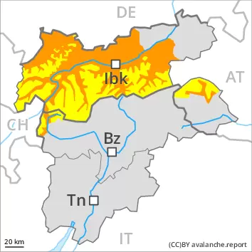
Danger level
2600m
Avalanche Problem
Wet snow
2600m
Persistent weak layer
2200m
Moist slab avalanches and wet snow slides are the main danger. Weakly bonded old snow is to be evaluated with care and prudence.
In the early morning the natural activity of small and medium moist and wet avalanches will gradually increase, in particular on sunny slopes below approximately 2600 m, as well as on very steep shady slopes below approximately 2200 m.
Weak layers in the old snowpack can be released in very isolated cases by winter sport participants, especially on very steep shady slopes above approximately 2200 m, as well as on very steep east facing slopes above approximately 2400 m. The avalanches can be released in the weakly bonded old snow and reach medium size. Experience in the assessment of avalanche danger is required.
Snowpack
dp.10: springtime scenario dp.1: deep persistent weak layer
The surface of the snowpack will cool hardly at all during the overcast night and will already be soft in the early morning. These weather conditions will bring about a gradual weakening of the snowpack. Faceted weak layers exist in the old snowpack, especially on shady slopes above approximately 2200 m, as well as on east and west facing slopes above approximately 2400 m. The spring-like weather conditions gave rise to gradual moistening of the snowpack, especially on steep sunny slopes at high altitudes and in high Alpine regions, as well as on west, north and east facing slopes at intermediate and high altitudes.
Tendency
Outgoing longwave radiation during the night will be reduced in some case. Moist and wet avalanches are the main danger.
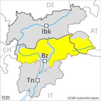
AM Danger level
2200m
Avalanche Problem
Persistent weak layer
2200m
PM Danger level
2200m
Avalanche Problem
Persistent weak layer
2200m
Wet snow
2600m
Weakly bonded old snow is to be evaluated with care and prudence. Wet avalanches as the day progresses.
Weak layers in the old snowpack can be released in very isolated cases by winter sport participants, especially on very steep shady slopes above approximately 2200 m, as well as on very steep east facing slopes above approximately 2400 m. The avalanches can be released in the weakly bonded old snow and reach medium size. As the day progresses the likelihood of wet avalanches being released will increase, in particular on sunny slopes, as well as on very steep west facing slopes below approximately 2600 m. Backcountry tours should be concluded timely.
Snowpack
dp.1: deep persistent weak layer
Faceted weak layers exist in the old snowpack, especially on shady slopes above approximately 2200 m, as well as on east and west facing slopes above approximately 2400 m. Outgoing longwave radiation during the night will be reduced in some case. The surface of the snowpack is frozen, but not to a significant depth and will already soften in the late morning. These weather conditions will bring about a gradual weakening of the snowpack.
Tendency
Outgoing longwave radiation during the night will be reduced in some case. As the day progresses as a consequence of warming during the day and solar radiation there will be an increase in the danger of wet avalanches.
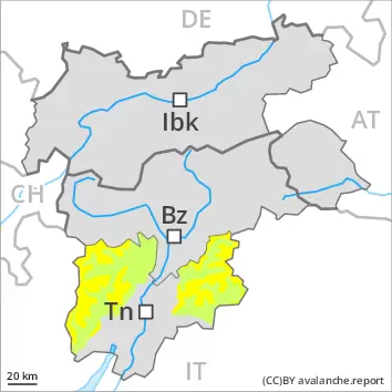
Danger level
2400m
Avalanche Problem
Wet snow
2400m
The early morning will see favourable avalanche conditions mostly, but the danger of wet avalanches will increase later.
As the day progresses the likelihood of wet avalanches being released will increase, in particular on sunny slopes, as well as on very steep east and west facing slopes below approximately 2400 m, also on steep shady slopes below approximately 2200 m. In some places avalanches can release the wet snowpack and reach medium size. Backcountry tours should be concluded timely.
Snowpack
dp.10: springtime scenario
Outgoing longwave radiation during the night will be reduced in some case. The surface of the snowpack is frozen, but not to a significant depth and will soften quickly. These weather conditions will bring about a gradual weakening of the snowpack. Only a small amount of snow is lying for the time of year at low and intermediate altitudes.
Tendency
Outgoing longwave radiation during the night will be reduced in some case. Moist and wet avalanches are the main danger.
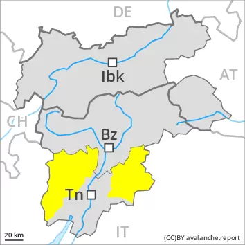
Danger level
Moist and wet snow slides are the main danger.
In the early morning the natural activity of small and medium moist and wet avalanches will gradually increase, in particular on sunny slopes at elevated altitudes, as well as on very steep shady slopes below approximately 2200 m.
Weak layers in the old snowpack can be released in very isolated cases by winter sport participants.
Snowpack
dp.10: springtime scenario dp.1: deep persistent weak layer
The surface of the snowpack will cool hardly at all during the overcast night and will already be soft in the early morning. These weather conditions will bring about a gradual weakening of the snowpack. Faceted weak layers exist in the old snowpack. The spring-like weather conditions gave rise to gradual moistening of the snowpack, especially on steep sunny slopes at high altitude, as well as on west, north and east facing slopes at intermediate and high altitudes.
Tendency
Outgoing longwave radiation during the night will be reduced in some case. Moist and wet avalanches are the main danger.