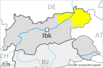
Danger level
 | 2800m |
|  |
|  | ||||
|  |
|  |


![]()
Natural wet avalanches are to be expected. Weakly bonded old snow is to be evaluated with care and prudence.
From late morning, individual, then as a consequence of warming during the day more, and in some cases even large, wet avalanches are to be expected. This applies on sunny slopes below approximately 2800 m, as well as on west and east facing slopes below approximately 2600 m, in isolated cases also on north facing slopes below approximately 2400 m. As a consequence of the rain, the likelihood of wet avalanches being released will increase in particular on shady slopes below approximately 2400 m. Backcountry tours and ascents to alpine cabins should be started very early and concluded timely. Extensive experience in the assessment of avalanche danger is required.
Weak layers in the old snowpack can be released in very isolated cases by winter sport participants, especially on very steep shady slopes above approximately 2400 m. The avalanches can be released in the weakly bonded old snow and reach medium size. Caution is to be exercised in particular on extremely steep northeast facing slopes.
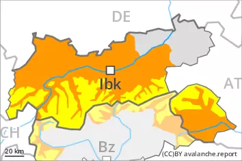
Snowpack
dp.10: springtime scenario
dp.1: deep persistent weak layer
The spring-like weather conditions gave rise to increasing and thorough wetting of the snowpack. Outgoing longwave radiation during the night will be reduced over a wide area. The surface of the snowpack is frozen, but not to a significant depth and will soften quickly. All aspects, below approximately 2800 m: The snowpack will become increasingly wet all the way through. At higher altitudes the snowpack is dryer.
Up to 2400 m rain will fall from the afternoon in some regions. At higher altitudes in some localities up to 10 cm of snow will fall.
Faceted weak layers exist in the old snowpack, especially on shady slopes above approximately 2400 m.
Tendency
As a consequence of new snow and wind there will be only a slight increase in the danger of dry avalanches, in particular at high altitudes and in high Alpine regions. As a consequence of solar radiation individual loose snow avalanches are possible. In the regions exposed to heavier precipitation this applies in particular on extremely steep sunny slopes. Gradual decrease in danger of wet avalanches as the temperature drops.