Natural wet avalanches are possible. Weakly bonded old snow is to be evaluated with care and prudence.
Already in the early morning, individual, then as a consequence of warming during the day more, and in some cases even medium-sized, wet avalanches are possible. This applies on sunny slopes below approximately 2600 m, as well as on west and east facing slopes below approximately 2400 m, in isolated cases also on north facing slopes below approximately 2200 m. As a consequence of solar radiation more frequent loose snow avalanches are to be expected. In the regions exposed to heavier precipitation this applies in particular on extremely steep sunny slopes.
Weak layers in the old snowpack can be released in very isolated cases by winter sport participants, especially on very steep shady slopes above approximately 2400 m. The avalanches can be released in the weakly bonded old snow and reach medium size. Caution is to be exercised in particular on extremely steep northeast facing slopes.
Fresh wind slabs require caution, in particular in the regions exposed to heavier precipitation at high altitudes and in high Alpine regions.
Snowpack
dp.10: springtime scenario dp.1: deep persistent weak layer
Up to 2400 m rain has fallen in some regions. The weather conditions gave rise to increasing and thorough wetting of the snowpack. Outgoing longwave radiation during the night will be severely restricted. The surface of the snowpack will freeze very little and will soften quickly. All aspects, below approximately 2600 m: The snowpack will be wet all the way through over a wide area. At higher altitudes the snowpack is dryer.
Faceted weak layers exist in the old snowpack, especially on shady slopes above approximately 2400 m.
Tendency
Gradual decrease in danger of wet avalanches. Some snow will fall on Sunday in some regions, in particular in the north.
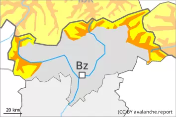
Danger level
2600m
Avalanche Problem
Wet snow
2600m
Persistent weak layer
2400m
Natural wet avalanches are possible. Weakly bonded old snow is to be evaluated with care and prudence.
Already in the early morning, individual wet avalanches are possible. In some cases they are medium-sized. This applies on sunny slopes below approximately 2600 m, as well as on west and east facing slopes below approximately 2400 m, in isolated cases also on north facing slopes below approximately 2200 m. As a consequence of solar radiation individual loose snow avalanches are to be expected. In the regions exposed to snowfall this applies in particular on extremely steep sunny slopes.
Weak layers in the old snowpack can be released in very isolated cases by winter sport participants, especially on very steep shady slopes above approximately 2400 m. The avalanches can be released in the weakly bonded old snow and reach medium size. Caution is to be exercised in particular on extremely steep northeast facing slopes.
Fresh wind slabs require caution, in particular in the regions exposed to heavier precipitation at high altitudes and in high Alpine regions.
Snowpack
dp.10: springtime scenario dp.1: deep persistent weak layer
Up to 2400 m rain has fallen in some regions. The weather conditions gave rise to increasing and thorough wetting of the snowpack. Outgoing longwave radiation during the night will be severely restricted. The surface of the snowpack will freeze very little and will soften quickly. All aspects, below approximately 2600 m: The snowpack will be wet all the way through over a wide area. At higher altitudes the snowpack is dryer.
Faceted weak layers exist in the old snowpack, especially on shady slopes above approximately 2400 m.
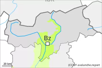
Tendency
Gradual decrease in danger of wet avalanches. Some snow will fall on Sunday in some localities.
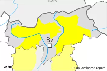
Danger level
Moist and wet snow slides are the main danger.
In the early morning the natural activity of small and medium moist and wet avalanches will gradually increase, in particular on sunny slopes at elevated altitudes, as well as on very steep shady slopes below approximately 2200 m.
Weak layers in the old snowpack can be released in very isolated cases by winter sport participants.
Snowpack
dp.10: springtime scenario dp.1: deep persistent weak layer
The surface of the snowpack will cool hardly at all during the overcast night and will already be soft in the early morning. The weather conditions gave rise to gradual and thorough wetting of the snowpack. These conditions will bring about a weakening of the snowpack.