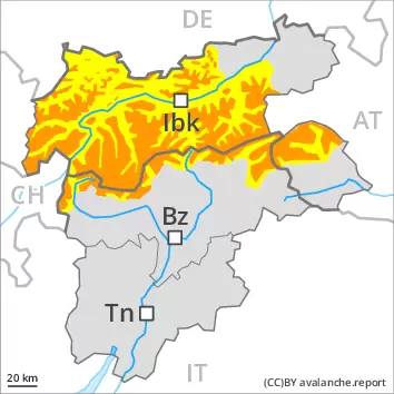
Fresh wind slabs require caution. Wet avalanches below approximately 2200 m.
The wind slabs of the last few days can be released even by a single winter sport participant. The avalanche prone locations are to be found in particular on steep west, north and east facing slopes above approximately 2200 m. Caution is to be exercised in gullies and bowls, and behind abrupt changes in the terrain. At elevated altitudes the likelihood of avalanches being released is greater. Dry avalanches can additionally in some places be released in near-surface layers in particular on steep sunny slopes, in particular above approximately 2500 m. Avalanches can reach large size in isolated cases. Wet avalanches are possible below approximately 2200 m. On extremely steep slopes loose snow avalanches are to be expected, in the event of prolonged bright spells especially.
Snowpack
dp.6: cold, loose snow and wind dp.4: cold following warm / warm following cold
5 to 10 cm of snow, and even more in some localities, fell on Friday. As a consequence of the occasionally strong northwesterly wind, fresh snow drift accumulations will form on Saturday. These are prone to triggering in particular on west to north to east facing aspects above approximately 2200 m. At elevated altitudes the snowpack is weaker. Faceted weak layers exist in the top section of the snowpack in particular on sunny slopes, especially above approximately 2500 m.
The rain will give rise on Friday to thorough wetting of the snowpack over a wide area below approximately 2200 m. Outgoing longwave radiation during the night will be reduced in some case. The surface of the snowpack will freeze very little. The solar radiation will give rise as the day progresses to moistening of the snowpack below approximately 2200 m.
Tendency
On Sunday the wind will be moderate to strong. The wind slabs remain prone to triggering at elevated altitudes. On sunny slopes the snowpack will soften during the day.
Danger level
2200m
Avalanche Problem
Wind slab
2200m
Wet snow
2200m
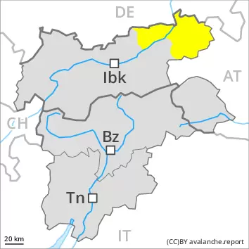
Fresh wind slabs require caution. Wet avalanches below approximately 2200 m.
The wind slabs of the last few days can be released by a single winter sport participant in some cases. The avalanche prone locations are to be found in particular on steep west, north and east facing slopes above approximately 2200 m. Caution is to be exercised in particular adjacent to ridgelines. At elevated altitudes the likelihood of avalanches being released is greater.
Wet avalanches are possible below approximately 2200 m. On extremely steep slopes loose snow avalanches are to be expected, in the event of prolonged bright spells especially.
Snowpack
dp.6: cold, loose snow and wind dp.4: cold following warm / warm following cold
5 to 10 cm of snow, and even more in some localities, fell on Friday. As a consequence of the occasionally strong northwesterly wind, fresh snow drift accumulations will form on Saturday. These are prone to triggering in particular on west to north to east facing aspects above approximately 2200 m. At elevated altitudes the snowpack is weaker.
The rain will give rise on Friday to thorough wetting of the snowpack over a wide area below approximately 2200 m. Outgoing longwave radiation during the night will be reduced in some case. The surface of the snowpack will freeze very little. The solar radiation will give rise as the day progresses to moistening of the snowpack below approximately 2200 m.
Tendency
On Sunday the wind will be moderate to strong. The wind slabs remain prone to triggering at elevated altitudes. On sunny slopes the snowpack will soften during the day.
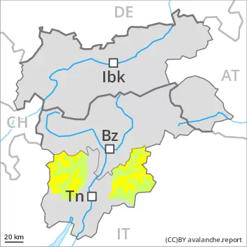
The fresh wind slabs can be released by a single winter sport participant in some cases. They must be evaluated with care and prudence above approximately 2200 m. At elevated altitudes the likelihood of avalanches being released is greater. Additionally in isolated cases dry avalanches can also penetrate deep layers. Avalanches can reach medium size. On extremely steep slopes moist loose snow slides are possible.
Snowpack
dp.6: cold, loose snow and wind
0 to 5 cm of snow, and even more in some localities, fell on Friday. As a consequence of the moderate to strong northwesterly wind, fresh snow drift accumulations will form on Saturday. These are prone to triggering above approximately 2200 m. At elevated altitudes the snowpack is weaker. Faceted weak layers exist in the old snowpack, especially on steep shady slopes above approximately 2400 m.
Outgoing longwave radiation during the night will be reduced in some case. The surface of the snowpack will only just freeze. The solar radiation will give rise as the day progresses to increasing moistening of the snowpack below approximately 2200 m. The snowpack will be generally subject to considerable local variations.
Tendency
On Sunday the wind will be moderate to strong. The wind slabs remain prone to triggering at elevated altitudes. On sunny slopes the snowpack will soften during the day.
The fresh wind slabs can be released by a single winter sport participant in some cases. They are to be evaluated with care and prudence in particular on west to north to east facing aspects above approximately 2200 m. At elevated altitudes the likelihood of avalanches being released is greater. Additionally in isolated cases dry avalanches can also penetrate deep layers. Avalanches can reach medium size. On extremely steep slopes moist loose snow slides are to be expected.
Snowpack
dp.6: cold, loose snow and wind
5 to 10 cm of snow, and even more in some localities, fell on Friday. As a consequence of the occasionally strong northwesterly wind, fresh snow drift accumulations will form on Saturday. These are prone to triggering in particular on west to north to east facing aspects above approximately 2200 m. At elevated altitudes the snowpack is weaker. Faceted weak layers exist in the old snowpack, especially on steep shady slopes above approximately 2400 m.
Outgoing longwave radiation during the night will be reduced in some case. The surface of the snowpack will only just freeze. The solar radiation will give rise as the day progresses to increasing moistening of the snowpack below approximately 2200 m. The snowpack will be generally subject to considerable local variations.
Tendency
On Sunday the wind will be moderate to strong. The wind slabs remain prone to triggering at elevated altitudes. On sunny slopes the snowpack will soften during the day.
Danger level
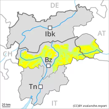
Low avalanche danger will prevail. Fresh wind slabs require caution.
The fresh wind slabs are very small and can only be released in isolated cases. Individual avalanche prone locations are to be found on extremely steep slopes and at elevated altitudes. These places are very rare and are clearly recognisable to the trained eye.
Snowpack
dp.6: cold, loose snow and wind
Fresh and somewhat older wind slabs are mostly small and can only be released in isolated cases. The old snowpack is largely stable. Outgoing longwave radiation during the night will be reduced in some case. The surface of the snowpack will only just freeze. The solar radiation will give rise as the day progresses to increasing moistening of the snowpack below approximately 2200 m. From a snow sport perspective, in most cases insufficient snow is lying.
Tendency
The weather effects will foster a strengthening of the snowpack.