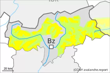
The wind slabs can be released by a single winter sport participant in some cases. They are to be evaluated with care and prudence in particular on northwest to north to northeast facing aspects above approximately 2500 m. At elevated altitudes the likelihood of avalanches being released is greater. Additionally in isolated cases dry avalanches can also penetrate deep layers, in particular on extremely steep shady slopes at elevated altitudes in areas where the snow cover is rather shallow. Avalanches can reach medium size. On extremely steep sunny slopes moist loose snow slides are possible.
Snowpack
dp.6: cold, loose snow and wind
More recent wind slabs are lying on soft layers in particular on northwest to north to northeast facing aspects at elevated altitudes. In very isolated cases weak layers exist in the old snowpack, especially on steep shady slopes at elevated altitudes. The wind will be moderate to strong. The weather conditions as the day progresses will give rise to moistening of the snowpack at low and intermediate altitudes. The snowpack will be generally subject to considerable local variations.
Tendency
The weather conditions as the day progresses will give rise to moistening of the snowpack at low and intermediate altitudes.
Danger level
2200m
Avalanche Problem
Wind slab
2200m
Persistent weak layer
2500m
Wind slabs and weakly bonded old snow require caution, especially at elevated altitudes.
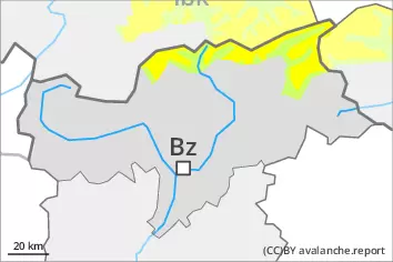
The fresh wind slabs can be released by a single winter sport participant. The avalanche prone locations are to be found in particular on very steep southwest, north and east facing slopes above approximately 2200 m. Caution is to be exercised in particular adjacent to ridgelines. At elevated altitudes the likelihood of avalanches being released is greater. Dry avalanches can additionally in some places be released in near-surface layers in particular on very steep sunny slopes, in particular above approximately 2500 m. Avalanches can reach large size in isolated cases. On extremely steep sunny slopes loose snow avalanches are to be expected, in the event of prolonged bright spells especially.
Snowpack
dp.6: cold, loose snow and wind dp.4: cold following warm / warm following cold
10 to 20 cm of snow, and even more in some localities, has fallen since yesterday. As a consequence of the moderate to strong northerly wind, fresh snow drift accumulations will form. These are lying on soft layers at elevated altitudes. Faceted weak layers exist in the top section of the snowpack in particular on sunny slopes, especially above approximately 2500 m. In very isolated cases weak layers exist in the bottom section of the old snowpack, especially on steep shady slopes at elevated altitudes in areas where the snow cover is rather shallow. The solar radiation will give rise to a loss of strength within the snowpack.
Tendency
The snowpack remains prone to triggering at elevated altitudes.
Danger level
2500m
Avalanche Problem
Wind slab
2500m
Persistent weak layer
2500m
Wind slabs and weakly bonded old snow require caution, especially at elevated altitudes.
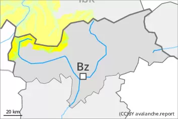
The wind slabs of the last few days can be released by a single winter sport participant. The avalanche prone locations are to be found in particular on very steep northwest, north and east facing slopes above approximately 2500 m. At elevated altitudes the likelihood of avalanches being released is greater. Dry avalanches can additionally in some places be released in near-surface layers in particular on very steep sunny slopes, in particular above approximately 2500 m. Avalanches can reach large size in isolated cases. On extremely steep sunny slopes loose snow slides are to be expected, in the event of prolonged bright spells especially.
Snowpack
dp.6: cold, loose snow and wind dp.4: cold following warm / warm following cold
10 to 20 cm of snow, and even more in some localities, has fallen since Thursday. As a consequence of the occasionally strong wind, fresh snow drift accumulations formed. These are lying on soft layers in particular on northwest to north to east facing aspects at elevated altitudes. Faceted weak layers exist in the top section of the snowpack in particular on sunny slopes, especially above approximately 2500 m. In very isolated cases weak layers exist in the bottom section of the old snowpack, especially on steep shady slopes at elevated altitudes in areas where the snow cover is rather shallow. The solar radiation will give rise to a loss of strength within the snowpack.
Tendency
The snowpack remains prone to triggering at elevated altitudes.
Danger level
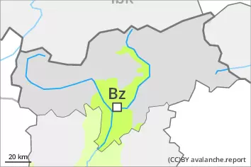
Low avalanche danger will prevail. Fresh wind slabs require caution.
The fresh wind slabs are very small and can only be released in isolated cases. Individual avalanche prone locations are to be found on extremely steep slopes and on wind-protected north facing slopes above approximately 2000 m. These places are very rare and are clearly recognisable to the trained eye.
Snowpack
dp.6: cold, loose snow and wind
The more recent wind slabs are mostly small and can only be released in isolated cases. The old snowpack is largely stable. The solar radiation will give rise as the day progresses to increasing moistening of the snowpack below approximately 2000 m. From a snow sport perspective, in most cases insufficient snow is lying.
Tendency
The weather effects will foster a strengthening of the snowpack.