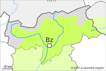
Danger level
 | 2600m |
|  |
|  | ||||
| |
|  |


![]()
Wind slabs and weakly bonded old snow require caution. Moist snow slides as the day progresses.
The near-surface layers of the snowpack can still be released in isolated cases by winter sport participants, especially on very steep north, northeast and east facing slopes above approximately 2600 m, in isolated cases also on very steep sunny slopes. Avalanches can reach medium size.
In addition the wind slabs adjacent to ridgelines and at elevated altitudes are capable of being triggered in isolated cases. They are to be evaluated with care and prudence in particular in very steep terrain.
As the moisture increases wet snow slides are possible, especially on extremely steep slopes.
In the evening as a consequence of the snowfall there will be a gradual increase in the danger of dry avalanches.
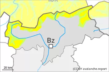
Snowpack
dp.4: cold following warm / warm following cold
dp.6: cold, loose snow and wind
Faceted weak layers exist in the top section of the snowpack, especially above approximately 2600 m.
The fresh and older wind slabs are in isolated cases prone to triggering on shady slopes at elevated altitudes.
The weather conditions will give rise to gradual moistening of the snowpack.
Over a wide area 5 to 10 cm of snow will fall in the evening. The fresh snow and the wind slabs that are being formed by the wind will be deposited on soft layers in particular on shady slopes at elevated altitudes.
Tendency
The old snowpack remains prone to triggering at elevated altitudes. Over a wide area 30 cm of snow, and even more in some localities, will fall on Thursday. Increase in danger of dry avalanches as a consequence of the snowfall.