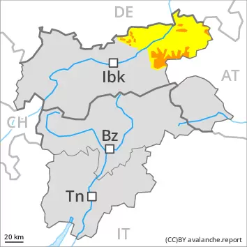
The new snow and wind slabs represent the main danger. Increase in avalanche danger as a consequence of the snowfall.
The fresh snow and the wind slabs that are being formed by the wind can be released easily, even by a single winter sport participant,. The avalanche prone locations are to be found on steep slopes of all aspects above approximately 2200 m, especially adjacent to ridgelines and in gullies and bowls. At elevated altitudes the likelihood of avalanches being released is greater. The avalanche prone locations are barely recognisable because of the poor visibility. As a consequence of new snow and wind the prevalence and size of the avalanche prone locations will increase as the day progresses. Avalanches can reach medium size. On extremely steep slopes loose snow avalanches are to be expected. In the event of prolonged bright spells this applies in particular. Experience and restraint are advisable.
Snowpack
dp.6: cold, loose snow and wind
Over a wide area 10 to 30 cm of snow, and even more in some localities, will fall on Thursday. As a consequence of a moderate wind from variable directions, avalanche prone wind slabs will form. The various wind slabs have bonded poorly together. In some cases new snow and wind slabs are lying on the soft surface of an old snowpack, especially on shady slopes at elevated altitudes. The snowpack will become increasingly prone to triggering.
Tendency
Friday: As a consequence of new snow and wind, further wind slabs will form. The avalanche danger will persist.
Danger level
2200m
Avalanche Problem
Wind slab
2200m
New snow
2000m
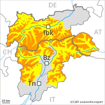
The new snow and wind slabs represent the main danger. Increase in avalanche danger as a consequence of the snowfall.
The fresh snow and the wind slabs that are being formed by the wind can be released easily, even by a single winter sport participant,. The avalanche prone locations are to be found on steep slopes of all aspects above approximately 2200 m. Caution is to be exercised adjacent to ridgelines and in gullies and bowls. The avalanche prone locations are barely recognisable because of the poor visibility. At elevated altitudes the likelihood of avalanches being released is greater. As a consequence of new snow and wind the prevalence and size of the avalanche prone locations will increase as the day progresses. Avalanches can reach quite a large size. In addition in particular on northwest, north and east facing slopes, individual natural avalanches are possible, especially above approximately 2600 m on the Main Alpine Ridge. On extremely steep slopes loose snow avalanches are to be expected, even medium-sized ones. In the event of prolonged bright spells this applies in particular. In addition in the regions exposed to heavier precipitation, small and, in isolated cases, medium-sized gliding avalanches are possible, especially on steep grassy slopes at intermediate and high altitudes. Experience and restraint are required.
Snowpack
dp.6: cold, loose snow and wind dp.4: cold following warm / warm following cold
Over a wide area 20 to 40 cm of snow, and even more in some localities, will fall on Thursday above approximately 1000 m. As a consequence of a gathering strong wind from variable directions, avalanche prone wind slabs will form. The various wind slabs have bonded poorly together. In some cases new snow and wind slabs are lying on the soft surface of an old snowpack, in particular on shady slopes at elevated altitudes. The snowpack will become increasingly prone to triggering. Isolated avalanche prone weak layers exist in the old snowpack on very steep northwest, north and east facing slopes, especially above approximately 2600 m on the Main Alpine Ridge.
Tendency
The wind will be strong over a wide area. The new snow and wind slabs remain prone to triggering.
Danger level
2000m
Avalanche Problem
Wind slab
2000m
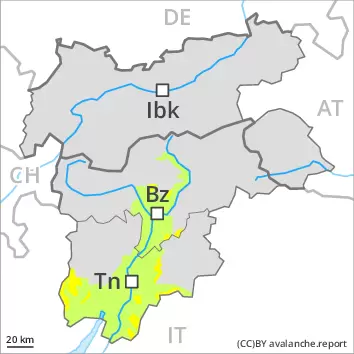
Fresh wind slabs require caution.
The fresh wind slabs can be released by a single winter sport participant in some cases. The avalanche prone locations are to be found in particular on steep west to north to east facing slopes above approximately 2000 m. Caution is to be exercised adjacent to ridgelines and in gullies and bowls. At elevated altitudes the likelihood of avalanches being released is greater. As a consequence of new snow and wind the prevalence and size of the avalanche prone locations will increase as the day progresses. Avalanches can reach medium size in isolated cases. On extremely steep slopes loose snow avalanches are possible.
Snowpack
dp.6: cold, loose snow and wind
Over a wide area 10 to 20 cm of snow, and even more in some localities, will fall on Thursday. In some places wind slabs are lying on soft layers, in particular on steep shady slopes at elevated altitudes. As a consequence of a gathering strong wind from variable directions, further wind slabs will form.
Tendency
The wind will be strong. Wind slabs remain prone to triggering in particular on shady slopes.