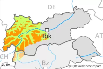
As a consequence of the new snow there will be an increase in the avalanche danger. Weakly bonded old snow is to be avoided.
The new snow can be released by a single winter sport participant. The avalanche prone locations are to be found in particular on steep shady slopes. At high altitudes and in high Alpine regions the avalanche prone locations are present in all aspects. The number and size of avalanche prone locations will increase with altitude. These avalanche prone locations are sometimes covered with new snow and are difficult to recognise. As a consequence of the new snow individual small and, in isolated cases, medium-sized loose snow avalanches are possible. In isolated cases avalanches can also release deeper layers of the snowpack and reach large size, especially on very steep west, north and east facing slopes above approximately 2400 m. Evening: As the snowfall level rises natural avalanches are possible below approximately 2400 m.
Snowpack
dp.6: cold, loose snow and wind dp.4: cold following warm / warm following cold
Up to 20 cm of snow will fall on Thursday. In some places new snow is lying on soft layers. Faceted weak layers exist in the old snowpack on very steep west, north and east facing slopes, especially above approximately 2400 m on the Main Alpine Ridge.
Tendency
Hardly any decrease in danger. Some snow will fall.
Danger level
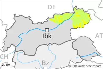
2200m
Avalanche Problem
New snow
2200m
Persistent weak layer
2400m
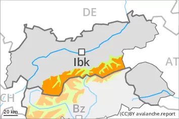
As a consequence of the new snow there will be an increase in the avalanche danger. Weakly bonded old snow is to be avoided.
The new snow can be released by a single winter sport participant. The avalanche prone locations are to be found in particular on steep shady slopes. At high altitudes and in high Alpine regions the avalanche prone locations are present in all aspects. The number and size of avalanche prone locations will increase with altitude. These avalanche prone locations are sometimes covered with new snow and are difficult to recognise. As a consequence of the new snow individual small and, in isolated cases, medium-sized loose snow avalanches are possible. In isolated cases avalanches can also release deeper layers of the snowpack and reach large size, especially on very steep west, north and east facing slopes above approximately 2400 m. Evening: As the snowfall level rises natural avalanches are possible below approximately 2400 m.
Snowpack
dp.6: cold, loose snow and wind dp.4: cold following warm / warm following cold
20 to 30 cm of snow, and up to 40 cm in some localities, will fall on Thursday. In some places new snow is lying on soft layers. Faceted weak layers exist in the old snowpack on very steep west, north and east facing slopes, especially above approximately 2400 m on the Main Alpine Ridge.
Tendency
Hardly any decrease in danger. Some snow will fall.
Danger level
2200m
Avalanche Problem
Wind slab
2200m
Persistent weak layer
2400m
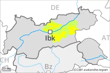
As a consequence of the new snow there will be an increase in the avalanche danger. Weakly bonded old snow is to be avoided.
The new snow can be released by a single winter sport participant. The avalanche prone locations are to be found in particular on steep shady slopes and in gullies and bowls, and behind abrupt changes in the terrain. The number and size of avalanche prone locations will increase with altitude. These avalanche prone locations are sometimes covered with new snow and are difficult to recognise. In isolated cases avalanches can also release deeper layers of the snowpack and reach large size, especially on very steep west, north and east facing slopes above approximately 2400 m.
Snowpack
dp.6: cold, loose snow and wind dp.4: cold following warm / warm following cold
Up to 20 cm of snow will fall on Thursday. In some places new snow is lying on a weakly bonded old snowpack. Faceted weak layers exist in the old snowpack on very steep west, north and east facing slopes, especially above approximately 2400 m on the Main Alpine Ridge.
Tendency
Hardly any decrease in danger.
Danger level
treeline
Avalanche Problem
Wind slab
Treeline
As a consequence of new snow and wind there will be an increase in the avalanche danger.
Avalanches can in some places be released, even by a single winter sport participant and reach medium size. The avalanche prone locations are to be found in particular on steep shady slopes and in gullies and bowls, and behind abrupt changes in the terrain. The number and size of avalanche prone locations will increase with altitude. Isolated small and medium-sized loose snow avalanches are possible as a consequence of the new snow. In isolated cases avalanches can also release deeper layers of the snowpack, especially on very steep west, north and east facing slopes above approximately 2400 m.
Snowpack
dp.6: cold, loose snow and wind
10 to 20 cm of snow will fall on Thursday. In some places new snow is lying on soft layers. Faceted weak layers exist in the old snowpack on very steep west, north and east facing slopes, especially above approximately 2400 m on the Main Alpine Ridge.
Tendency
Hardly any decrease in danger. Some snow will fall.
Danger level
1600m
Avalanche Problem
Wind slab
1600m
Fresh wind slabs are to be avoided.
The fresh wind slabs can be released by a single winter sport participant in isolated cases. The avalanche prone locations are to be found in particular on very steep shady slopes above approximately 1600 m, especially at transitions into gullies and bowls. In very isolated cases avalanches are medium-sized.
Snowpack
dp.6: cold, loose snow and wind
The snowpack will be quite well bonded. In isolated cases wind slabs are lying on soft layers, in particular on steep shady slopes. At low altitude only a little snow is now lying.