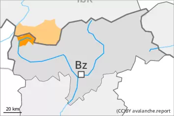
Weakly bonded old snow and wet snow represent the main danger. Natural avalanches must be expected more frequently.
Natural moist avalanches are to be expected, this applies already in the early morning. The avalanche prone locations are to be found in all aspects below approximately 2700 m. In isolated cases avalanches can also release deeper layers of the snowpack and reach large size, especially on very steep west, north and east facing slopes above approximately 2400 m. More small and, in isolated cases, medium-sized loose snow avalanches are possible. The danger of natural wet avalanches will increase during the day.
Weakly bonded old snow is to be evaluated critically, in particular on steep shady slopes at high altitudes and in high Alpine regions. Avalanches can in some cases be released easily and reach large size.
Snowpack
dp.10: springtime scenario dp.4: cold following warm / warm following cold
As a consequence of sharply rising temperatures and high relative humidity an unfavourable avalanche situation will develop by the early morning. The meteorological conditions will prevent a stabilisation of the snowpack during the night.
Avalanche prone weak layers exist in the top section of the snowpack in particular on steep shady slopes. Some snow will fall in some localities.
Tendency
Slight increase in avalanche danger as a consequence of new snow and wind. Afternoon: As a consequence of solar radiation more frequent loose snow avalanches are to be expected, especially on extremely steep sunny slopes.
Danger level
2700m
Avalanche Problem
Wet snow
2700m
Persistent weak layer
2400m
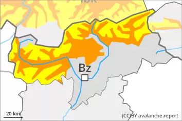
Wet snow represents the main danger. Natural avalanches must be expected more frequently.
Natural moist avalanches are to be expected, this applies already in the early morning. The avalanche prone locations are to be found in all aspects below approximately 2700 m. In isolated cases avalanches can also release deeper layers of the snowpack and reach large size, especially on very steep west, north and east facing slopes above approximately 2400 m. More small and, in isolated cases, medium-sized loose snow avalanches are possible. The danger of natural wet avalanches will increase during the day.
Fresh wind slabs require caution, in particular on steep shady slopes in high Alpine regions.
Snowpack
dp.10: springtime scenario dp.4: cold following warm / warm following cold
As a consequence of sharply rising temperatures and high relative humidity an unfavourable avalanche situation will develop by the early morning. The meteorological conditions will prevent a stabilisation of the snowpack during the night.
Avalanche prone weak layers exist in the top section of the snowpack in particular on steep shady slopes. Some snow will fall in some localities.
Tendency
Slight increase in avalanche danger as a consequence of new snow and wind. Afternoon: As a consequence of solar radiation more frequent loose snow avalanches are to be expected, especially on extremely steep sunny slopes.
Danger level
Avalanche Problem
Wet snow
Persistent weak layer
2200m
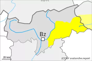
Wet snow requires caution. Weakly bonded old snow requires caution.
Natural wet avalanches are to be expected, this applies already in the early morning. The avalanche prone locations are to be found in all aspects. The danger of wet avalanches will increase during the day.
Weakly bonded old snow is to be evaluated critically, in particular on steep shady slopes. Avalanches can in some cases be released in near-surface layers and reach large size in isolated cases in particular in the regions with a lot of snow.
Snowpack
dp.10: springtime scenario dp.4: cold following warm / warm following cold
As a consequence of sharply rising temperatures and high relative humidity an unfavourable avalanche situation will develop by the early morning. The meteorological conditions will prevent a stabilisation of the snowpack during the night.
Avalanche prone weak layers exist in the top section of the snowpack in particular on steep shady slopes. Some snow will fall in some localities.
Tendency
Slight increase in avalanche danger as a consequence of new snow and wind. Afternoon: As a consequence of solar radiation more frequent loose snow avalanches are to be expected, especially on extremely steep sunny slopes.
Danger level
Wet snow requires caution.
Only isolated wet snow slides and avalanches are possible, this applies already in the early morning. The avalanche prone locations are to be found in all aspects. The danger of wet avalanches will increase during the day. Apart from the danger of being buried, restraint should be exercised in particular in view of the danger of avalanches sweeping people along and giving rise to falls.
Snowpack
dp.6: cold, loose snow and wind
As a consequence of mild temperatures and high relative humidity the snowpack can not consolidate during the night. At low and intermediate altitudes hardly any snow is lying.
Tendency
From a snow sport perspective, in most cases insufficient snow is lying.