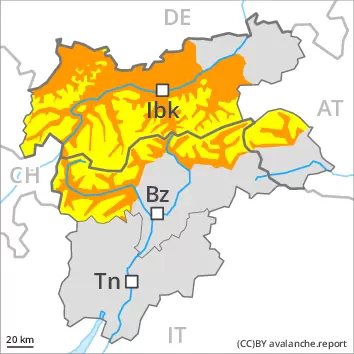
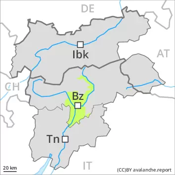
Weakly bonded old snow and wet snow are to be critically assessed. This is the final hazard map for the winter 2022/23. Regular avalanche bulletins with hazard maps will appear again from around the start of December, depending on the snow situation.
Wet avalanches can in some places be released, even by a single winter sport participant. This applies in all aspects below approximately 2600 m. Avalanches can also release deeper layers of the snowpack and reach large size in isolated cases, especially on steep north facing slopes at high altitude.
In isolated cases dry avalanches can be triggered in the weakly bonded old snow, in particular on very steep shady slopes above approximately 2600 m. Dry avalanches can in isolated cases penetrate deep layers and reach large size.
On steep grassy slopes more gliding avalanches are possible.
Snowpack
dp.10: springtime scenario dp.4: cold following warm / warm following cold
The spring-like weather conditions gave rise to thorough wetting of the snowpack over a wide area, especially below approximately 2600 m. Outgoing longwave radiation during the night will be severely restricted. Down to high altitudes snow will fall in particular in the west. The snowpack remains weakly bonded.
Avalanche prone weak layers exist in the old snowpack in particular on steep shady slopes.
Tendency
Tuesday: As a consequence of falling temperatures, the activity of wet avalanches will decrease. Down to high altitudes snow will fall. As a consequence of new snow and a moderate to strong northerly wind, mostly small wind slabs will form in high Alpine regions. This applies especially on the Main Alpine Ridge and to the south.
Danger level
Avalanche Problem
Wet snow
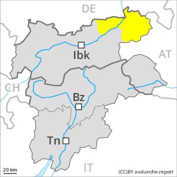
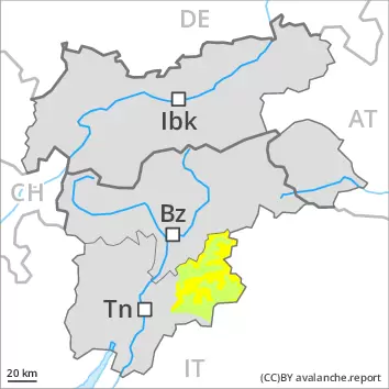
Moderate danger of wet avalanches will be encountered over a wide area. This is the final hazard map for the winter 2022/23. Regular avalanche bulletins with hazard maps will appear again from around the start of December, depending on the snow situation.
Wet avalanches can in some places be released by people and reach medium size. The avalanche prone locations are to be found on steep slopes of all aspects above approximately 2000 m.
Snowpack
dp.10: springtime scenario
The spring-like weather conditions gave rise to increasing and thorough wetting of the snowpack over a wide area. Outgoing longwave radiation during the night will be severely restricted. Down to high altitudes snow will fall. The snowpack remains weakly bonded.
Tendency
Tuesday: Moderate danger of wet avalanches will be encountered over a wide area.
Danger level
Avalanche Problem
Wet snow
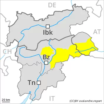
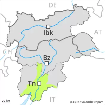
Moderate danger of wet avalanches will be encountered over a wide area. This is the final hazard map for the winter 2022/23. Regular avalanche bulletins with hazard maps will appear again from around the start of December, depending on the snow situation.
Wet avalanches can in some places be released easily and reach medium size. The avalanche prone locations are to be found on steep slopes of all aspects. Avalanches can in isolated cases release deeper layers of the snowpack, especially on steep north facing slopes at high altitude.
Snowpack
dp.10: springtime scenario
The spring-like weather conditions gave rise to thorough wetting of the snowpack over a wide area, especially below approximately 2600 m. Outgoing longwave radiation during the night will be severely restricted. Down to high altitudes snow will fall. The snowpack remains weakly bonded.
Isolated avalanche prone weak layers exist in the old snowpack in particular on steep shady slopes.
Tendency
Tuesday: As a consequence of falling temperatures, the activity of wet avalanches will decrease. Down to high altitudes snow will fall. As a consequence of new snow and a moderate to strong northerly wind, small wind slabs will form in high Alpine regions.
Danger level
2200m
Avalanche Problem
Persistent weak layer
2200m
Wind slab
2200m
Weakly bonded old snow and wet snow require caution.
More recent wind slabs are to be assessed with care and prudence. The avalanche prone locations are sometimes covered with new snow and are difficult to recognise. Additionally in some places avalanches can also penetrate deep layers and reach quite a large size. Increase in danger of dry and wet avalanches in particular in the regions exposed to precipitation.
Snowpack
dp.10: springtime scenario
The Avalanche Warning Service currently has only a small amount of information that has been collected in the high Alpine regions, so that the avalanche danger should be investigated especially thoroughly in the relevant locality.
Tendency
Up to 2000 m and above rain will fall on Monday over a wide area. In addition the danger of dry and wet avalanches will increase.
Danger level
2200m
Avalanche Problem
Persistent weak layer
2200m
Wet snow
2600m
2200m
Weakly bonded old snow and wet snow require caution.
More recent wind slabs are to be assessed with care and prudence. The avalanche prone locations are sometimes covered with new snow and are difficult to recognise. Additionally in some places avalanches can also penetrate deep layers. Increase in danger of wet avalanches in particular in the regions exposed to precipitation.
Snowpack
dp.10: springtime scenario
The Avalanche Warning Service currently has only a small amount of information that has been collected in the high Alpine regions, so that the avalanche danger should be investigated especially thoroughly in the relevant locality. The sleet will give rise in the afternoon to moistening of the snowpack.
Tendency
Up to 2000 m and above rain will fall on Monday over a wide area. In addition the danger of dry and wet avalanches will increase.
Danger level
In all aspects a little snow is lying.
Increase in danger of wet snow slides as a consequence of the rain.
Snowpack
dp.10: springtime scenario
At low and intermediate altitudes from a snow sport perspective, in most cases insufficient snow is lying.
Tendency
Up to 2000 m and above rain will fall on Monday over a wide area.
Danger level
Avalanche Problem
Wet snow
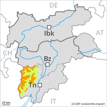
Wet snow represents the main danger. This is the final hazard map for the winter 2022/23. Regular avalanche bulletins with hazard maps will appear again from around the start of December, depending on the snow situation.
More wet avalanches are possible, but they will be mostly small. The avalanche prone locations are to be found on steep slopes of all aspects. Restraint should be exercised because avalanches can sweep people along and give rise to falls.
Snowpack
dp.10: springtime scenario
The snowpack will be wet all the way through. Outgoing longwave radiation during the night will be barely evident. Some rain will fall.
Tendency
Only a little snow is now lying. Low avalanche danger will persist.