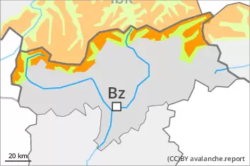
New snow and wind slabs represent the main danger. Weakly bonded old snow above approximately 2400 m.
As a consequence of new snow and a storm force northwesterly wind, avalanche prone wind slabs formed in the last few days especially in gullies and bowls and behind abrupt changes in the terrain. Some fresh snow as well as the wind slabs that are forming above the tree line are to be evaluated with care and prudence. The brittle wind slabs can be released by a single winter sport participant in all aspects above the tree line. These are barely recognisable because of the poor visibility. Also slopes close to the tree line are unfavourable. Avalanches are medium-sized.
Additionally avalanches can also be triggered in the old snowpack and reach large size, especially on steep shady slopes above approximately 2400 m, as well as on steep sunny slopes above approximately 2800 m. Experience in the assessment of avalanche danger is required.
Snowpack
dp.6: cold, loose snow and wind dp.4: cold following warm / warm following cold
In particular from the Oetztal Alps via the Karwendel Mountains to the High Tauern 10 to 20 cm of snow will fall. Some snow will fall on the Main Alpine Ridge and to the south. The snowpack will be subject to considerable local variations. Snow depths vary greatly above the tree line, depending on the infuence of the wind.
The new snow and wind slabs remain prone to triggering above the tree line. The snowpack will be prone to triggering in areas close to the tree line. The new snow and wind slabs will be deposited on soft layers on wind-protected shady slopes at elevated altitudes. Faceted weak layers exist in the centre of the snowpack. This applies in particular on steep northwest, north and northeast facing slopes above approximately 2400 m, as well as on steep east and west facing slopes above approximately 2600 m, also on steep sunny slopes above approximately 2800 m. Shooting cracks when stepping on the snowpack and whumpfing sounds confirm the unfavourable bonding of the snowpack.
Tendency
Gradual decrease in avalanche danger.
Danger level
treeline
Avalanche Problem
Wind slab
Treeline
Persistent weak layer
2400m
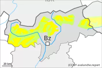
Fresh wind slabs require caution. Weakly bonded old snow at high altitudes and in high Alpine regions.
As a consequence of new snow and a storm force northwesterly wind, avalanche prone wind slabs formed in the last few days especially in gullies and bowls and behind abrupt changes in the terrain. The brittle wind slabs can be released even by a single winter sport participant in all aspects at high altitudes and in high Alpine regions. In regions neighbouring those that are subject to danger level 3 (considerable) the avalanche prone locations are more prevalent. Weakly bonded old snow: In isolated cases avalanches can be released in deep layers of the snowpack and reach quite a large size, especially on steep shady slopes above approximately 2400 m, as well as on steep sunny slopes above approximately 2800 m. Apart from the danger of being buried, restraint should be exercised as well in view of the danger of avalanches sweeping people along and giving rise to falls. The Avalanche Warning Service currently has only a small amount of information, so that the avalanche danger should be investigated especially thoroughly in the relevant locality.
Snowpack
dp.6: cold, loose snow and wind dp.1: deep persistent weak layer
Some snow will fall during the night in some localities. In particular in the north 10 to 20 cm of snow, and even more in some localities, fell in the last few days. The new snow and wind slabs are prone to triggering above the tree line. The new snow and wind slabs will be deposited on soft layers on wind-protected shady slopes at elevated altitudes. Faceted weak layers exist in the old snowpack, especially on steep shady slopes above approximately 2400 m, as well as on steep sunny slopes above approximately 2800 m. The snowpack will be subject to considerable local variations. Snow depths vary greatly above the tree line, depending on the infuence of the wind.
Tendency
The weather effects will prevent a decrease in the avalanche danger. Fresh wind slabs represent the main danger.
Danger level
2400m
Avalanche Problem
Wind slab
2400m
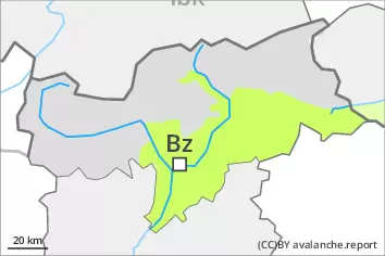
The fresh and somewhat older wind slabs represent the main danger.
As a consequence of a storm force northwesterly wind, clearly visible wind slabs formed in the last few days especially in gullies and bowls and behind abrupt changes in the terrain. The mostly small wind slabs can be released even by a single winter sport participant especially on very steep shady slopes at high altitudes and in high Alpine regions. The avalanche prone locations are rather rare. In the north the avalanche prone locations are a little more prevalent. Restraint should be exercised because avalanches can sweep people along and give rise to falls. The Avalanche Warning Service currently has only a small amount of information, so that the avalanche danger should be investigated especially thoroughly in the relevant locality.
Snowpack
dp.6: cold, loose snow and wind
Some snow will fall during the night in some localities. From a snow sport perspective, in most cases insufficient snow is lying. The snowpack is largely stable and its surface has a crust, in particular on steep sunny slopes in all altitude zones, as well as on shady slopes below approximately 2400 m. The snowpack will be subject to considerable local variations. Snow depths vary greatly above the tree line, depending on the infuence of the wind.